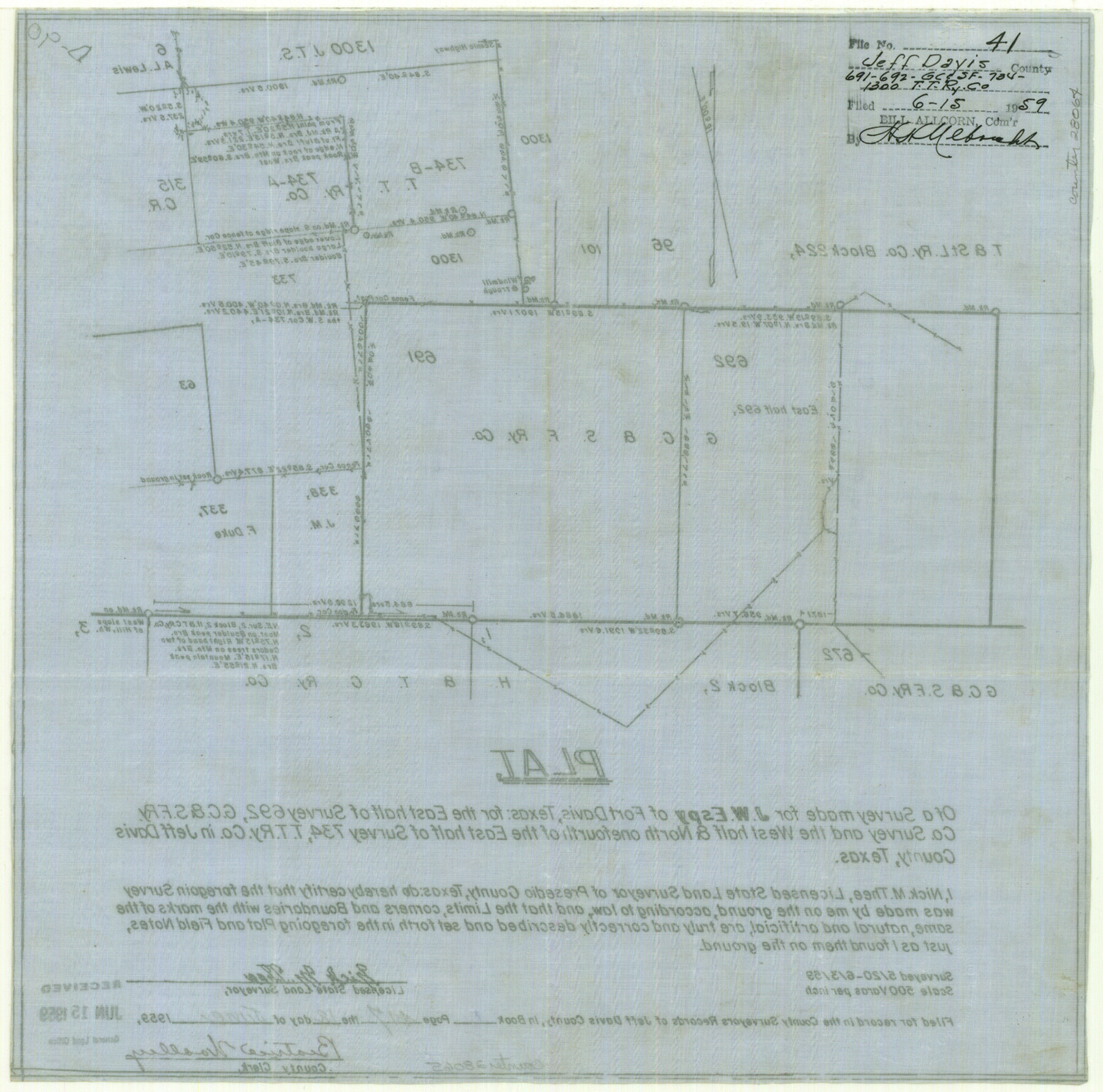
Jeff Davis County Sketch File 41
Plat of a survey made for J. W. Espy of Fort Davis, Texas for the east half of survey 692, G. C. & S. F. RR. Co. survey and the west half and north 1/4 of the east half of survey 734, T. T. RR. Co.]
-
Map/Doc
28064
-
Collection
General Map Collection
-
Object Dates
6/12/1959 (Creation Date)
6/15/1959 (File Date)
5/20/1959 (Survey Date)
6/3/1959 (Survey Date)
-
People and Organizations
Nick M. Thee (Surveyor/Engineer)
-
Counties
Jeff Davis
-
Subjects
Surveying Sketch File
-
Height x Width
13.3 x 13.4 inches
33.8 x 34.0 cm
-
Medium
paper, manuscript
-
Scale
1:500
-
Features
Boulder Peak
Part of: General Map Collection
Lavaca County Working Sketch 2

Print $20.00
- Digital $50.00
Lavaca County Working Sketch 2
1904
Size 19.2 x 31.2 inches
Map/Doc 70355
Stephens County Sketch File 5

Print $6.00
- Digital $50.00
Stephens County Sketch File 5
Size 10.0 x 13.3 inches
Map/Doc 37019
Crockett County Rolled Sketch 68

Print $20.00
- Digital $50.00
Crockett County Rolled Sketch 68
1947
Size 25.8 x 38.7 inches
Map/Doc 5611
Kleberg County Rolled Sketch 11

Print $20.00
- Digital $50.00
Kleberg County Rolled Sketch 11
1915
Size 21.0 x 26.5 inches
Map/Doc 6552
Menard County Sketch File 18

Print $62.00
- Digital $50.00
Menard County Sketch File 18
1893
Size 8.7 x 8.1 inches
Map/Doc 31516
San Patricio County Working Sketch 9

Print $40.00
- Digital $50.00
San Patricio County Working Sketch 9
1937
Size 52.8 x 44.0 inches
Map/Doc 63771
Right of Way and Track Map, the Missouri, Kansas and Texas Ry. of Texas - Henrietta Division

Print $20.00
- Digital $50.00
Right of Way and Track Map, the Missouri, Kansas and Texas Ry. of Texas - Henrietta Division
1918
Size 11.7 x 26.9 inches
Map/Doc 64749
DeWitt County Working Sketch 8

Print $20.00
- Digital $50.00
DeWitt County Working Sketch 8
1979
Size 35.7 x 41.9 inches
Map/Doc 68598
Hopkins County Sketch File 27

Print $6.00
- Digital $50.00
Hopkins County Sketch File 27
1873
Size 16.6 x 11.0 inches
Map/Doc 26738
Real County Rolled Sketch 18

Print $20.00
- Digital $50.00
Real County Rolled Sketch 18
Size 22.0 x 28.0 inches
Map/Doc 7463
Controlled Mosaic by Jack Amman Photogrammetric Engineers, Inc - Sheet 5

Print $20.00
- Digital $50.00
Controlled Mosaic by Jack Amman Photogrammetric Engineers, Inc - Sheet 5
1954
Size 20.8 x 24.0 inches
Map/Doc 83449
Shelby County Sketch File 13

Print $2.00
- Digital $50.00
Shelby County Sketch File 13
1859
Size 8.2 x 12.8 inches
Map/Doc 36621
You may also like
Leon County Working Sketch 5

Print $20.00
- Digital $50.00
Leon County Working Sketch 5
1905
Size 40.5 x 20.6 inches
Map/Doc 70404
[South line of Blocks B24, B25, and B26]
![90463, [South line of Blocks B24, B25, and B26], Twichell Survey Records](https://historictexasmaps.com/wmedia_w700/maps/90463-1.tif.jpg)
Print $2.00
- Digital $50.00
[South line of Blocks B24, B25, and B26]
1936
Size 14.6 x 9.0 inches
Map/Doc 90463
Dickens County Rolled Sketch P1

Print $20.00
- Digital $50.00
Dickens County Rolled Sketch P1
1915
Size 40.5 x 36.2 inches
Map/Doc 8783
Shackelford County Boundary File 6

Print $6.00
- Digital $50.00
Shackelford County Boundary File 6
Size 11.4 x 8.8 inches
Map/Doc 58668
Drainage Basins of Texas Streams

Print $20.00
- Digital $50.00
Drainage Basins of Texas Streams
Size 35.3 x 42.0 inches
Map/Doc 65270
Flight Mission No. CUG-3P, Frame 34, Kleberg County

Print $20.00
- Digital $50.00
Flight Mission No. CUG-3P, Frame 34, Kleberg County
1956
Size 18.5 x 22.3 inches
Map/Doc 86239
Frio County Rolled Sketch 24

Print $20.00
- Digital $50.00
Frio County Rolled Sketch 24
1964
Size 22.3 x 21.1 inches
Map/Doc 5924
Borden County Working Sketch 10

Print $20.00
- Digital $50.00
Borden County Working Sketch 10
1953
Size 32.2 x 20.4 inches
Map/Doc 67470
[Part of Eastern Texas RR. Co. Block 1]
![91897, [Part of Eastern Texas RR. Co. Block 1], Twichell Survey Records](https://historictexasmaps.com/wmedia_w700/maps/91897-1.tif.jpg)
Print $20.00
- Digital $50.00
[Part of Eastern Texas RR. Co. Block 1]
Size 12.0 x 16.2 inches
Map/Doc 91897
Martin County

Print $20.00
- Digital $50.00
Martin County
1933
Size 43.8 x 38.9 inches
Map/Doc 73230
[McLennan County School Leagues 3 and 4, Elizabeth Finley, Wm. Van Norman, Harvey Kendrick surveys and surveys to the west]
![90929, [McLennan County School Leagues 3 and 4, Elizabeth Finley, Wm. Van Norman, Harvey Kendrick surveys and surveys to the west], Twichell Survey Records](https://historictexasmaps.com/wmedia_w700/maps/90929-1.tif.jpg)
Print $20.00
- Digital $50.00
[McLennan County School Leagues 3 and 4, Elizabeth Finley, Wm. Van Norman, Harvey Kendrick surveys and surveys to the west]
Size 19.5 x 26.7 inches
Map/Doc 90929
Galveston County Sketch File 34

Print $20.00
- Digital $50.00
Galveston County Sketch File 34
1934
Size 11.5 x 20.1 inches
Map/Doc 11536