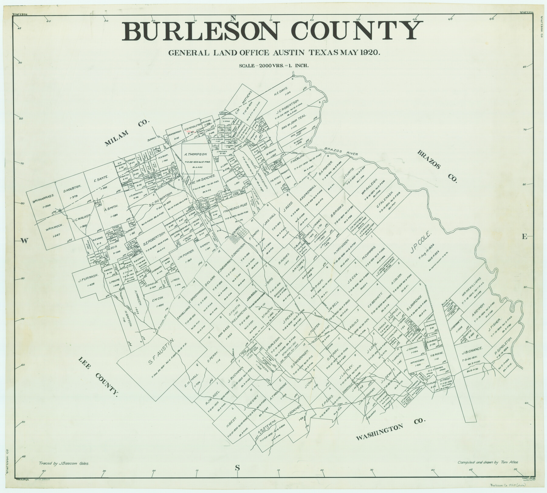
Burleson County
-
Map/Doc
66740
-
Collection
General Map Collection
-
Object Dates
1920 (Creation Date)
-
People and Organizations
Texas General Land Office (Publisher)
Tom G. Atlee (Draftsman)
Tom G. Atlee (Compiler)
-
Counties
Burleson
-
Subjects
County
-
Height x Width
40.7 x 45.2 inches
103.4 x 114.8 cm
-
Comments
Traced by J. Bascom Giles.
Part of: General Map Collection
Runnels County Sketch File 25

Print $20.00
Runnels County Sketch File 25
1940
Size 16.5 x 16.7 inches
Map/Doc 12259
Hutchinson County Rolled Sketch 44-13

Print $20.00
- Digital $50.00
Hutchinson County Rolled Sketch 44-13
2002
Size 24.0 x 36.0 inches
Map/Doc 77549
Marion County Rolled Sketch 4

Print $40.00
- Digital $50.00
Marion County Rolled Sketch 4
1951
Size 43.1 x 58.0 inches
Map/Doc 9491
Flight Mission No. BQR-13K, Frame 165, Brazoria County

Print $20.00
- Digital $50.00
Flight Mission No. BQR-13K, Frame 165, Brazoria County
1952
Size 18.8 x 22.3 inches
Map/Doc 84090
Jeff Davis County Rolled Sketch 5

Print $40.00
- Digital $50.00
Jeff Davis County Rolled Sketch 5
Size 34.7 x 48.6 inches
Map/Doc 9262
Maps of Gulf Intracoastal Waterway, Texas - Sabine River to the Rio Grande and connecting waterways including ship channels

Print $20.00
- Digital $50.00
Maps of Gulf Intracoastal Waterway, Texas - Sabine River to the Rio Grande and connecting waterways including ship channels
1966
Size 14.6 x 22.3 inches
Map/Doc 61954
Flight Mission No. CGI-3N, Frame 174, Cameron County

Print $20.00
- Digital $50.00
Flight Mission No. CGI-3N, Frame 174, Cameron County
1954
Size 18.5 x 22.1 inches
Map/Doc 84638
Mitchell County Working Sketch 7

Print $20.00
- Digital $50.00
Mitchell County Working Sketch 7
1963
Size 38.6 x 22.6 inches
Map/Doc 71064
Stephens County Working Sketch 38

Print $20.00
- Digital $50.00
Stephens County Working Sketch 38
1988
Size 24.3 x 32.7 inches
Map/Doc 63981
Jasper County Sketch File 19

Print $6.00
- Digital $50.00
Jasper County Sketch File 19
1890
Size 14.2 x 8.8 inches
Map/Doc 27815
Pecos County Rolled Sketch 154

Print $20.00
- Digital $50.00
Pecos County Rolled Sketch 154
Size 35.9 x 27.0 inches
Map/Doc 7283
Fayette County Sketch File 7

Print $4.00
- Digital $50.00
Fayette County Sketch File 7
1873
Size 8.5 x 12.8 inches
Map/Doc 22547
You may also like
General Highway Map. Detail of Cities and Towns in Harris County, Texas. City Map [of] Houston, Pasadena, West University Place, Bellaire, Galena Park, Jacinto City, South Houston, South Side Place, Deer Park, and vicinity, Harris County, Texas
![79507, General Highway Map. Detail of Cities and Towns in Harris County, Texas. City Map [of] Houston, Pasadena, West University Place, Bellaire, Galena Park, Jacinto City, South Houston, South Side Place, Deer Park, and vicinity, Harris County, Texas, Texas State Library and Archives](https://historictexasmaps.com/wmedia_w700/maps/79507.tif.jpg)
Print $20.00
General Highway Map. Detail of Cities and Towns in Harris County, Texas. City Map [of] Houston, Pasadena, West University Place, Bellaire, Galena Park, Jacinto City, South Houston, South Side Place, Deer Park, and vicinity, Harris County, Texas
1961
Size 18.1 x 24.7 inches
Map/Doc 79507
Bastrop County Boundary File 6

Print $20.00
- Digital $50.00
Bastrop County Boundary File 6
Size 8.8 x 7.9 inches
Map/Doc 50337
Amistad International Reservoir on Rio Grande 108

Print $20.00
- Digital $50.00
Amistad International Reservoir on Rio Grande 108
1950
Size 28.5 x 40.9 inches
Map/Doc 75539
Kimble County Working Sketch Graphic Index, Sheet 1 (Sketches 1 to 46)

Print $40.00
- Digital $50.00
Kimble County Working Sketch Graphic Index, Sheet 1 (Sketches 1 to 46)
1930
Size 41.2 x 49.6 inches
Map/Doc 76606
Map of the Cotton Belt Route, St. Louis Southwestern Railway Co., St. Louis Southwestern Railway Co. of Texas, Tyler Southeastern Railway Co. and connections

Print $20.00
- Digital $50.00
Map of the Cotton Belt Route, St. Louis Southwestern Railway Co., St. Louis Southwestern Railway Co. of Texas, Tyler Southeastern Railway Co. and connections
1898
Size 15.3 x 35.7 inches
Map/Doc 93954
Kinney County Working Sketch 9

Print $20.00
- Digital $50.00
Kinney County Working Sketch 9
1918
Size 20.4 x 20.4 inches
Map/Doc 70191
General Highway Map, Nacogdoches County, Texas

Print $20.00
General Highway Map, Nacogdoches County, Texas
1961
Size 19.3 x 25.0 inches
Map/Doc 79607
Starr County Rolled Sketch 2

Print $40.00
- Digital $50.00
Starr County Rolled Sketch 2
1853
Size 31.7 x 48.5 inches
Map/Doc 9938
Flight Mission No. DIX-6P, Frame 119, Aransas County

Print $20.00
- Digital $50.00
Flight Mission No. DIX-6P, Frame 119, Aransas County
1956
Size 19.1 x 22.7 inches
Map/Doc 83825
Terrell County Working Sketch 77

Print $20.00
- Digital $50.00
Terrell County Working Sketch 77
1983
Size 22.9 x 33.7 inches
Map/Doc 69598
Robertson County Working Sketch 14

Print $40.00
- Digital $50.00
Robertson County Working Sketch 14
1988
Size 50.0 x 40.8 inches
Map/Doc 78227
[Block 1 PO, Surveys 15, 16, and 17]
![91433, [Block 1 PO, Surveys 15, 16, and 17], Twichell Survey Records](https://historictexasmaps.com/wmedia_w700/maps/91433-1.tif.jpg)
Print $20.00
- Digital $50.00
[Block 1 PO, Surveys 15, 16, and 17]
1906
Size 16.6 x 15.6 inches
Map/Doc 91433