Irion County Sketch File 7
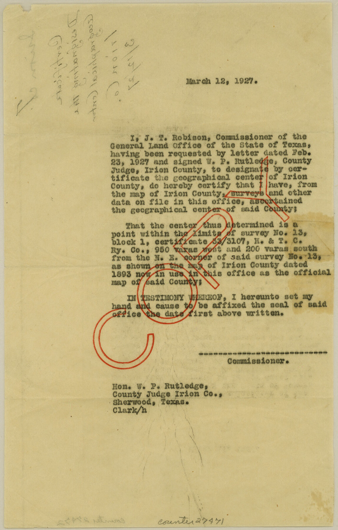
[Certificate designating the geographical center of Irion County]
-
Map/Doc
27471
-
Collection
General Map Collection
-
Object Dates
1927/3/12 (Creation Date)
1927/3/12 (Correspondence Date)
-
People and Organizations
J.T. Robison (GLO Commissioner)
-
Counties
Irion
-
Subjects
Surveying Sketch File
-
Height x Width
11.1 x 7.1 inches
28.2 x 18.0 cm
-
Medium
paper, print
Part of: General Map Collection
Fannin County Working Sketch 6

Print $20.00
- Digital $50.00
Fannin County Working Sketch 6
1939
Size 11.4 x 18.0 inches
Map/Doc 69160
Matagorda County Working Sketch 30

Print $20.00
- Digital $50.00
Matagorda County Working Sketch 30
1981
Size 21.0 x 19.7 inches
Map/Doc 70888
Hardeman County Sketch File 32

Print $4.00
- Digital $50.00
Hardeman County Sketch File 32
Size 11.1 x 8.9 inches
Map/Doc 25068
Liberty County Sketch File 60

Print $12.00
- Digital $50.00
Liberty County Sketch File 60
1943
Size 14.2 x 8.6 inches
Map/Doc 30071
Rusk County Sketch File 45

Print $8.00
Rusk County Sketch File 45
1959
Size 11.3 x 8.8 inches
Map/Doc 35591
Baylor County Aerial Photograph Index Sheet 3

Print $20.00
- Digital $50.00
Baylor County Aerial Photograph Index Sheet 3
1950
Size 20.4 x 15.5 inches
Map/Doc 83665
Galveston County NRC Article 33.136 Sketch 9

Print $22.00
- Digital $50.00
Galveston County NRC Article 33.136 Sketch 9
1999
Size 18.8 x 25.1 inches
Map/Doc 61591
Close-up: USA - The South Central States

Close-up: USA - The South Central States
1974
Size 23.2 x 35.2 inches
Map/Doc 96846
Grayson County Sketch File 25

Print $6.00
- Digital $50.00
Grayson County Sketch File 25
Size 8.4 x 7.1 inches
Map/Doc 24507
El Paso County Working Sketch 46

Print $20.00
- Digital $50.00
El Paso County Working Sketch 46
1987
Size 38.3 x 37.5 inches
Map/Doc 69068
Hardin County Working Sketch 2

Print $20.00
- Digital $50.00
Hardin County Working Sketch 2
1903
Size 23.2 x 21.9 inches
Map/Doc 63400
Flight Mission No. BRA-8M, Frame 67, Jefferson County

Print $20.00
- Digital $50.00
Flight Mission No. BRA-8M, Frame 67, Jefferson County
1953
Size 18.8 x 22.5 inches
Map/Doc 85587
You may also like
Runnels County Sketch File 14

Print $20.00
Runnels County Sketch File 14
1884
Size 16.3 x 20.4 inches
Map/Doc 12252

From Citizens of Shelby and Red River Counties Living East of the Sabine River and Southwest of the Sulphur Fork of Red River for the Creation of a New County to be Called Green, March 11, 1837/April 1, 1837

Print $20.00
From Citizens of Shelby and Red River Counties Living East of the Sabine River and Southwest of the Sulphur Fork of Red River for the Creation of a New County to be Called Green, March 11, 1837/April 1, 1837
2020
Size 24.3 x 21.7 inches
Map/Doc 96373
Plat of a portion of Buchel County, Texas

Print $20.00
- Digital $50.00
Plat of a portion of Buchel County, Texas
Size 16.0 x 26.2 inches
Map/Doc 82526
Map of Texas compiled from surveys at the Land Office of Texas

Print $20.00
- Digital $50.00
Map of Texas compiled from surveys at the Land Office of Texas
1851
Size 26.7 x 19.1 inches
Map/Doc 96431
Map of Callahan County, Texas

Print $20.00
- Digital $50.00
Map of Callahan County, Texas
1879
Size 24.6 x 19.6 inches
Map/Doc 4337
Kerr County Sketch File 11

Print $4.00
- Digital $50.00
Kerr County Sketch File 11
1889
Size 14.2 x 8.7 inches
Map/Doc 28879
Reeves County Rolled Sketch 30

Print $20.00
- Digital $50.00
Reeves County Rolled Sketch 30
1988
Size 18.4 x 24.4 inches
Map/Doc 7499
Kimble County Working Sketch 51

Print $20.00
- Digital $50.00
Kimble County Working Sketch 51
1953
Size 36.3 x 40.1 inches
Map/Doc 70119
Terry County Rolled Sketch 6

Print $20.00
- Digital $50.00
Terry County Rolled Sketch 6
1944
Size 36.5 x 43.7 inches
Map/Doc 9996
Karnes County Rolled Sketch 1

Print $20.00
- Digital $50.00
Karnes County Rolled Sketch 1
1943
Size 27.5 x 25.7 inches
Map/Doc 6452
