Rusk County Sketch File 45
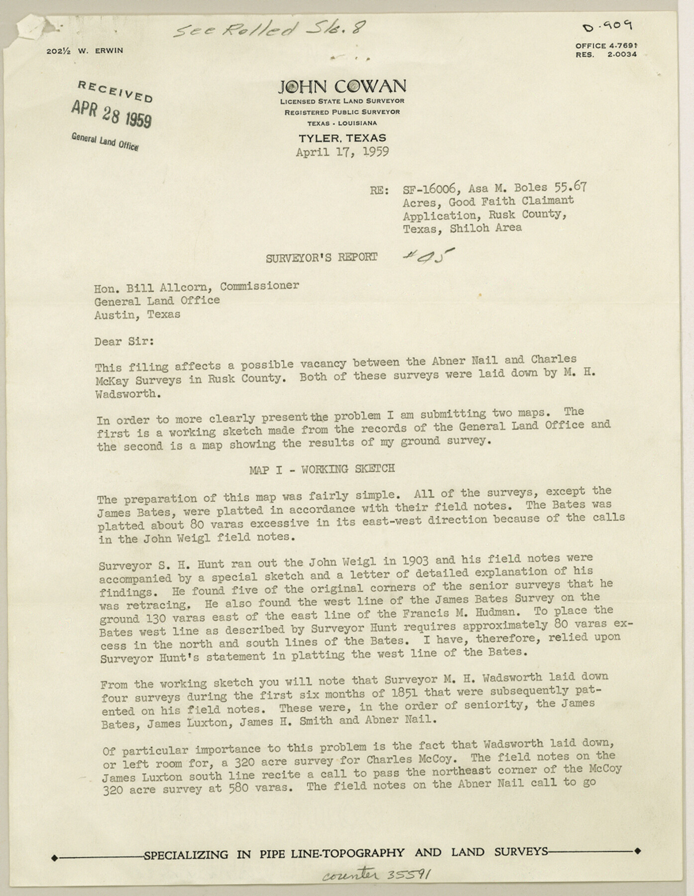
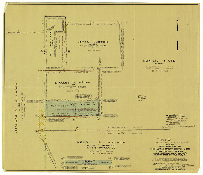
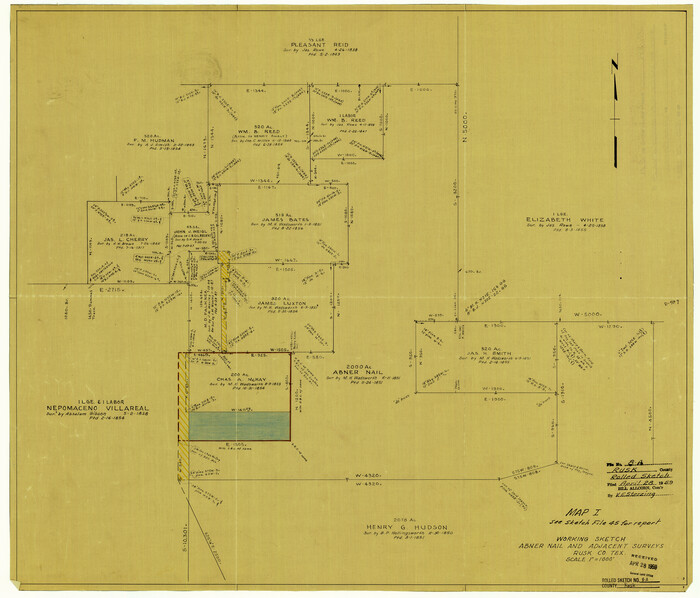
[Report regarding SF-16006, Asa M. Boles 55.67 acres, Good Faith Claimant Application]
-
Map/Doc
35591
-
Collection
General Map Collection
-
Object Dates
4/17/1959 (Creation Date)
4/28/1959 (File Date)
-
People and Organizations
John Cowan (Surveyor/Engineer)
-
Counties
Rusk
-
Subjects
Surveying Sketch File
-
Height x Width
11.3 x 8.8 inches
28.7 x 22.4 cm
-
Medium
paper, print
-
Comments
See Rusk County Rolled Sketch 8 (7544) and Rusk County Rolled Sketch 8A (7545) for sketches.
Related maps
Rusk County Rolled Sketch 8
Print $20.00
- Digital $50.00
Rusk County Rolled Sketch 8
1959
Size 22.6 x 26.3 inches
Map/Doc 7544
Rusk County Rolled Sketch 8A
Print $20.00
- Digital $50.00
Rusk County Rolled Sketch 8A
Size 22.4 x 26.2 inches
Map/Doc 7545
Part of: General Map Collection

Culberson County Working Sketch 11

Print $20.00
- Digital $50.00
Culberson County Working Sketch 11
1920
Size 29.6 x 22.9 inches
Map/Doc 68463
Map of Kaufman County

Print $20.00
- Digital $50.00
Map of Kaufman County
1867
Size 27.4 x 22.2 inches
Map/Doc 3749
Reagan County Sketch File 16

Print $8.00
- Digital $50.00
Reagan County Sketch File 16
1932
Size 11.1 x 7.7 inches
Map/Doc 35002
Andrews County Rolled Sketch 41

Print $20.00
- Digital $50.00
Andrews County Rolled Sketch 41
Size 18.0 x 24.0 inches
Map/Doc 77181
Newton County Rolled Sketch 23
Print $20.00
- Digital $50.00
Newton County Rolled Sketch 23
1893
Size 22.7 x 18.5 inches
Map/Doc 6850
Flight Mission No. DAG-16K, Frame 69, Matagorda County

Print $20.00
- Digital $50.00
Flight Mission No. DAG-16K, Frame 69, Matagorda County
1952
Size 18.4 x 22.2 inches
Map/Doc 86315
Zavala County Sketch File 7

Print $6.00
- Digital $50.00
Zavala County Sketch File 7
Size 9.4 x 16.3 inches
Map/Doc 41265
Walker County

Print $20.00
- Digital $50.00
Walker County
1944
Size 46.1 x 38.2 inches
Map/Doc 95664
Cottle County Sketch File KN

Print $20.00
- Digital $50.00
Cottle County Sketch File KN
Size 18.8 x 25.2 inches
Map/Doc 11203
Hockley County Sketch File 16

Print $20.00
- Digital $50.00
Hockley County Sketch File 16
Size 23.6 x 30.9 inches
Map/Doc 11774
United States - Gulf Coast Texas - Southern part of Laguna Madre

Print $20.00
- Digital $50.00
United States - Gulf Coast Texas - Southern part of Laguna Madre
1941
Size 18.4 x 27.5 inches
Map/Doc 72948
You may also like
[Sketch Between Collingsworth County and Oklahoma]
![89663, [Sketch Between Collingsworth County and Oklahoma], Twichell Survey Records](https://historictexasmaps.com/wmedia_w700/maps/89663-1.tif.jpg)
Print $40.00
- Digital $50.00
[Sketch Between Collingsworth County and Oklahoma]
Size 9.4 x 62.5 inches
Map/Doc 89663
Flight Mission No. DQN-7K, Frame 32, Calhoun County

Print $20.00
- Digital $50.00
Flight Mission No. DQN-7K, Frame 32, Calhoun County
1953
Size 18.6 x 22.2 inches
Map/Doc 84470
Rusk County Sketch File 26

Print $20.00
Rusk County Sketch File 26
1932
Size 38.1 x 22.6 inches
Map/Doc 10595
Flight Mission No. DAG-22K, Frame 87, Matagorda County

Print $20.00
- Digital $50.00
Flight Mission No. DAG-22K, Frame 87, Matagorda County
1953
Size 18.6 x 22.4 inches
Map/Doc 86471
Hardeman County Sketch File 17

Print $2.00
- Digital $50.00
Hardeman County Sketch File 17
Size 7.8 x 6.7 inches
Map/Doc 25025
Jasper County Working Sketch 12

Print $40.00
- Digital $50.00
Jasper County Working Sketch 12
1920
Size 50.6 x 38.3 inches
Map/Doc 66474
Rains County Sketch File 2

Print $4.00
- Digital $50.00
Rains County Sketch File 2
Size 10.1 x 7.4 inches
Map/Doc 34945
Van Zandt County Rolled Sketch 10

Print $20.00
- Digital $50.00
Van Zandt County Rolled Sketch 10
1989
Size 33.7 x 40.6 inches
Map/Doc 10092
Carte Reduite des Costes de la Louisiane et de la Floride

Print $20.00
Carte Reduite des Costes de la Louisiane et de la Floride
1764
Size 23.3 x 35.1 inches
Map/Doc 79295
Williamson County Sketch File 10

Print $22.00
- Digital $50.00
Williamson County Sketch File 10
1858
Size 12.2 x 17.1 inches
Map/Doc 40322
Eastland County Rolled Sketch 19

Print $20.00
- Digital $50.00
Eastland County Rolled Sketch 19
1980
Size 28.9 x 30.9 inches
Map/Doc 8825
Martin County Working Sketch 11

Print $40.00
- Digital $50.00
Martin County Working Sketch 11
1971
Size 49.8 x 38.1 inches
Map/Doc 70829