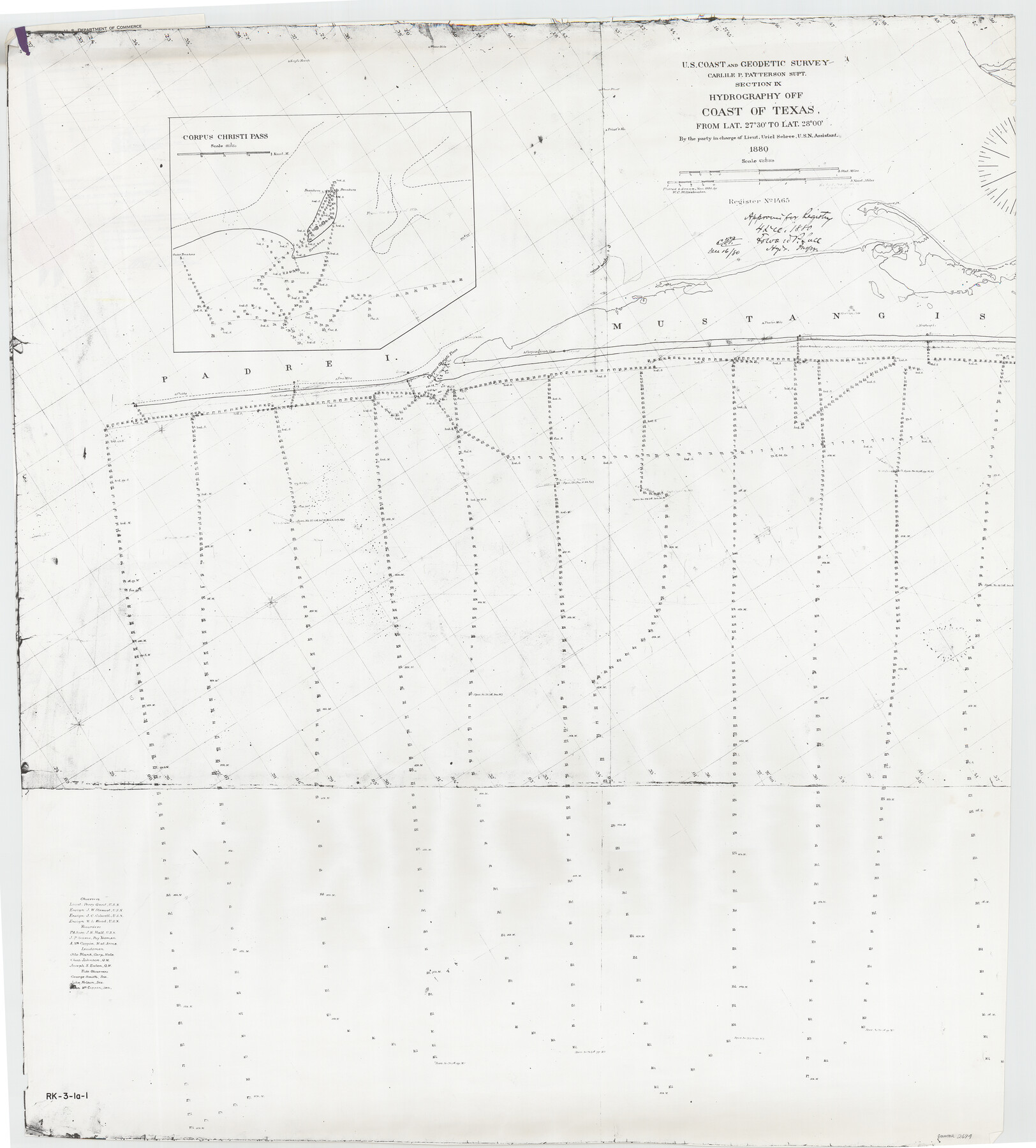
Corpus Christi Pass
Hydrography Off Coast of Texas from Latitude 27 Degrees, 30 minutes to Latitude 28 degrees 0 minutes
-
Map/Doc
2694
-
Collection
General Map Collection
-
Object Dates
1880 (Creation Date)
-
People and Organizations
U. S. Coast and Geodetic Survey (Author)
-
Subjects
Nautical Charts
-
Height x Width
45.5 x 41.0 inches
115.6 x 104.1 cm
-
Medium
photocopy
-
Scale
:40,000
-
Comments
See 83361 for Certificate
Part of: General Map Collection
Deaf Smith County Boundary File 1

Print $124.00
- Digital $50.00
Deaf Smith County Boundary File 1
Size 14.1 x 8.6 inches
Map/Doc 52372
Johnson County Working Sketch 30

Print $20.00
- Digital $50.00
Johnson County Working Sketch 30
2007
Size 40.9 x 42.0 inches
Map/Doc 83807
Gregg County Rolled Sketch 23

Print $40.00
- Digital $50.00
Gregg County Rolled Sketch 23
Size 52.9 x 43.3 inches
Map/Doc 9074
Bandera County Rolled Sketch 4

Print $20.00
- Digital $50.00
Bandera County Rolled Sketch 4
1963
Size 36.0 x 28.5 inches
Map/Doc 5116
[Sketch for Mineral Application 13440]
![65673, [Sketch for Mineral Application 13440], General Map Collection](https://historictexasmaps.com/wmedia_w700/maps/65673-1.tif.jpg)
Print $40.00
- Digital $50.00
[Sketch for Mineral Application 13440]
Size 42.4 x 66.0 inches
Map/Doc 65673
Map of Hemisfair '68 and Downtown San Antonio compliments of the Pearl Brewing Company

Print $3.00
- Digital $50.00
Map of Hemisfair '68 and Downtown San Antonio compliments of the Pearl Brewing Company
1968
Size 6.0 x 11.3 inches
Map/Doc 94793
Trinity River, Wire Bridge Sheet/Denton Creek

Print $6.00
- Digital $50.00
Trinity River, Wire Bridge Sheet/Denton Creek
1938
Size 30.4 x 29.7 inches
Map/Doc 65244
Rusk County Working Sketch 33

Print $20.00
- Digital $50.00
Rusk County Working Sketch 33
1919
Size 20.1 x 16.6 inches
Map/Doc 63670
Loving County Working Sketch 11

Print $40.00
- Digital $50.00
Loving County Working Sketch 11
1957
Size 21.6 x 50.9 inches
Map/Doc 70644
Dimmit County Sketch File 20

Print $6.00
- Digital $50.00
Dimmit County Sketch File 20
1884
Size 13.0 x 8.7 inches
Map/Doc 21100
Presidio County Sketch File 61

Print $3.00
- Digital $50.00
Presidio County Sketch File 61
1930
Size 9.3 x 15.4 inches
Map/Doc 89987
San Jacinto County Sketch File 20A

Print $6.00
San Jacinto County Sketch File 20A
1939
Size 13.9 x 8.9 inches
Map/Doc 35731
You may also like
Eastland County Working Sketch 3

Print $20.00
- Digital $50.00
Eastland County Working Sketch 3
1917
Size 16.5 x 20.2 inches
Map/Doc 68784
Flight Mission No. DIX-8P, Frame 89, Aransas County

Print $20.00
- Digital $50.00
Flight Mission No. DIX-8P, Frame 89, Aransas County
1956
Size 18.7 x 22.4 inches
Map/Doc 83914
Briscoe County Working Sketch 12

Print $40.00
- Digital $50.00
Briscoe County Working Sketch 12
1984
Size 43.6 x 60.3 inches
Map/Doc 67815
Bosque County Sketch File 4

Print $4.00
- Digital $50.00
Bosque County Sketch File 4
1854
Size 11.3 x 7.8 inches
Map/Doc 14744
Map of north end of Brazos Island

Print $20.00
- Digital $50.00
Map of north end of Brazos Island
1845
Size 24.2 x 18.3 inches
Map/Doc 72920
San Jacinto County Working Sketch 25

Print $20.00
- Digital $50.00
San Jacinto County Working Sketch 25
1943
Size 34.4 x 34.2 inches
Map/Doc 63738
Galveston County Working Sketch 10

Print $40.00
- Digital $50.00
Galveston County Working Sketch 10
1967
Size 24.7 x 119.8 inches
Map/Doc 69347
La Salle County Sketch File 41

Print $20.00
- Digital $50.00
La Salle County Sketch File 41
1918
Size 25.8 x 15.9 inches
Map/Doc 11986
Brazos Island Harbor, Texas - Dredging Entrance Channel Plan

Print $20.00
- Digital $50.00
Brazos Island Harbor, Texas - Dredging Entrance Channel Plan
1990
Size 14.6 x 20.0 inches
Map/Doc 83337
Nueces County Rolled Sketch 63

Print $20.00
- Digital $50.00
Nueces County Rolled Sketch 63
1979
Size 25.5 x 38.1 inches
Map/Doc 6909
Magnolia Road Map of Texas

Print $20.00
Magnolia Road Map of Texas
1933
Size 18.1 x 24.1 inches
Map/Doc 76301
Cooke County Working Sketch 14

Print $40.00
- Digital $50.00
Cooke County Working Sketch 14
1944
Size 34.1 x 49.7 inches
Map/Doc 68251