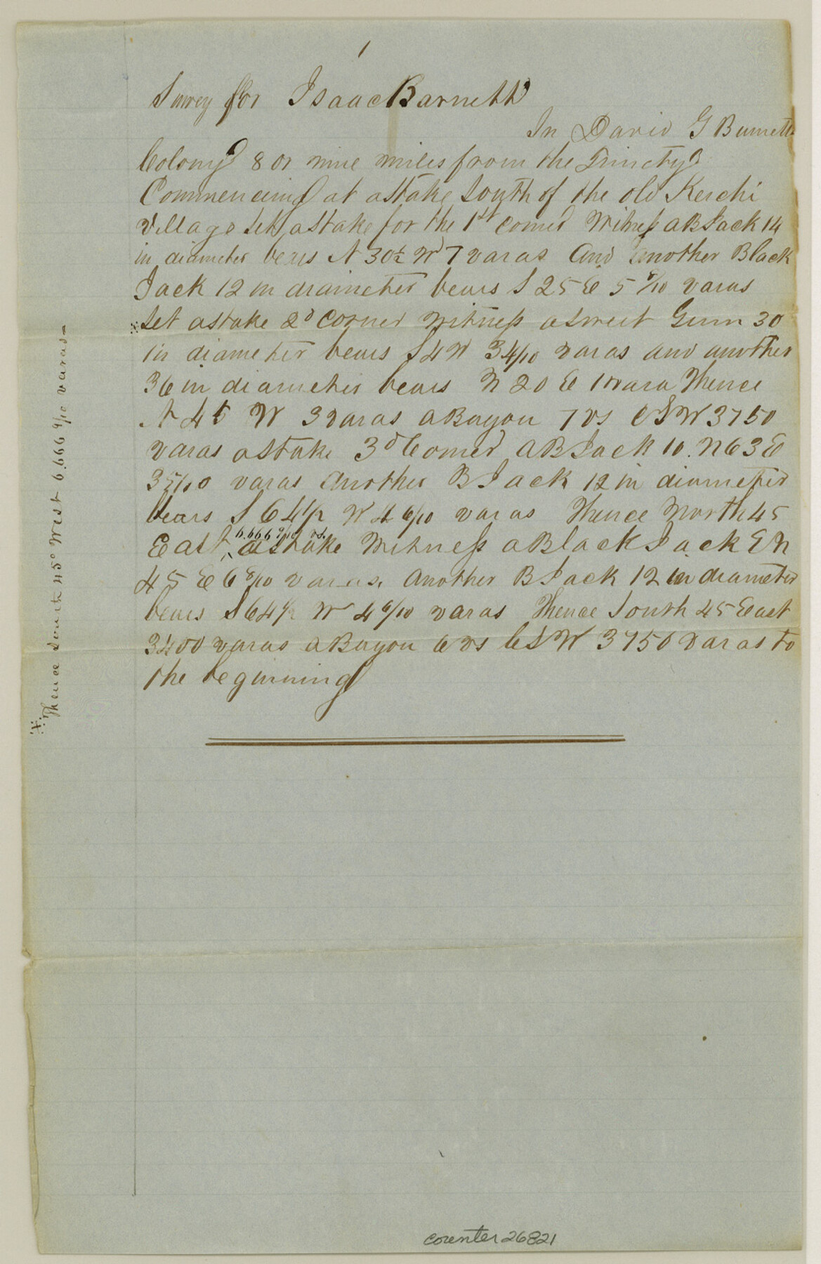
Houston County Sketch File 38
[Field notes of old surveys for: Isaac Barnett, P. Martin, J. Hertz, Pedro Barmela and J. Razin]
-
Map/Doc
26821
-
Collection
General Map Collection
-
Object Dates
11/28/1984 (File Date)
-
Counties
Houston Anderson
-
Subjects
Surveying Sketch File
-
Height x Width
12.8 x 8.3 inches
32.5 x 21.1 cm
-
Medium
paper, manuscript
-
Features
Trinity River
Keechi Village
Comanche Trace
Elkhart Creek
Hurricane Bayou
San Antonio Road
San Pedro Creek
Grass House Prairie
Part of: General Map Collection

Flight Mission No. CRK-8P, Frame 119, Refugio County

Print $20.00
- Digital $50.00
Flight Mission No. CRK-8P, Frame 119, Refugio County
1956
Size 18.3 x 22.0 inches
Map/Doc 86974
Upton County Rolled Sketch 59

Print $40.00
- Digital $50.00
Upton County Rolled Sketch 59
Size 37.8 x 48.4 inches
Map/Doc 10062
Hamilton County Working Sketch 24

Print $20.00
- Digital $50.00
Hamilton County Working Sketch 24
1979
Size 34.7 x 33.6 inches
Map/Doc 63362

Flight Mission No. CRC-4R, Frame 76, Chambers County

Print $20.00
- Digital $50.00
Flight Mission No. CRC-4R, Frame 76, Chambers County
1956
Size 18.8 x 22.4 inches
Map/Doc 84880
San Augustine County Working Sketch 9

Print $20.00
- Digital $50.00
San Augustine County Working Sketch 9
1935
Size 41.2 x 39.7 inches
Map/Doc 63696
Armstrong County Working Sketch 3

Print $20.00
- Digital $50.00
Armstrong County Working Sketch 3
1904
Size 46.1 x 40.8 inches
Map/Doc 67234
Flight Mission No. DAG-23K, Frame 169, Matagorda County

Print $20.00
- Digital $50.00
Flight Mission No. DAG-23K, Frame 169, Matagorda County
1953
Size 16.0 x 15.8 inches
Map/Doc 86507
Map of Leon County

Print $40.00
- Digital $50.00
Map of Leon County
Size 49.7 x 42.0 inches
Map/Doc 66900
County and Railroad Map of Texas

Print $20.00
- Digital $50.00
County and Railroad Map of Texas
1876
Size 17.0 x 16.0 inches
Map/Doc 93624
El Paso County Sketch File 35

Print $10.00
- Digital $50.00
El Paso County Sketch File 35
1886
Size 11.3 x 8.9 inches
Map/Doc 22161
You may also like
Flight Mission No. CRC-4R, Frame 72, Chambers County

Print $20.00
- Digital $50.00
Flight Mission No. CRC-4R, Frame 72, Chambers County
1956
Size 18.8 x 22.4 inches
Map/Doc 84876
Panola County Sketch File 8

Print $4.00
- Digital $50.00
Panola County Sketch File 8
1862
Size 12.8 x 7.8 inches
Map/Doc 33459
Houston County Sketch File 5a

Print $5.00
- Digital $50.00
Houston County Sketch File 5a
Size 8.5 x 9.4 inches
Map/Doc 26758
General Highway Map, Brewster County, Texas

Print $20.00
General Highway Map, Brewster County, Texas
1940
Size 18.5 x 25.2 inches
Map/Doc 79027
Wylie Briscoe Farm

Print $2.00
- Digital $50.00
Wylie Briscoe Farm
Size 9.2 x 15.2 inches
Map/Doc 92273

Karnes County Sketch File 14

Print $6.00
- Digital $50.00
Karnes County Sketch File 14
1897
Size 9.7 x 6.2 inches
Map/Doc 28615
General Highway Map, Jefferson County, Texas

Print $20.00
General Highway Map, Jefferson County, Texas
1961
Size 24.6 x 18.3 inches
Map/Doc 79537
Map of San Gabriel & Lampassas [sic] Surveys
![58, Map of San Gabriel & Lampassas [sic] Surveys, General Map Collection](https://historictexasmaps.com/wmedia_w700/maps/58.tif.jpg)
Print $20.00
- Digital $50.00
Map of San Gabriel & Lampassas [sic] Surveys
1841
Size 29.0 x 20.0 inches
Map/Doc 58
Liberty County Working Sketch 50

Print $20.00
- Digital $50.00
Liberty County Working Sketch 50
1955
Size 22.4 x 33.5 inches
Map/Doc 70510
Kimble County Working Sketch 43

Print $20.00
- Digital $50.00
Kimble County Working Sketch 43
1949
Size 34.6 x 37.6 inches
Map/Doc 70111
Jefferson County Working Sketch 35

Print $20.00
- Digital $50.00
Jefferson County Working Sketch 35
1982
Size 39.1 x 32.6 inches
Map/Doc 66579