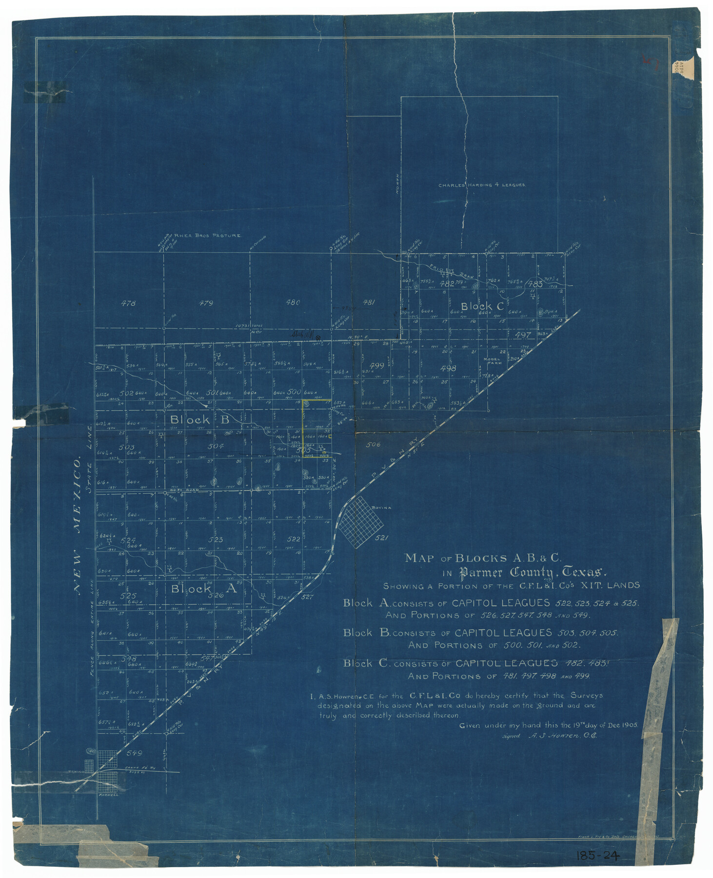
Map of Blocks A, B and C in Parmer County, Texas showing a portion of the C. F. L. & I. Co's. XIT Lands
185-24
-
Map/Doc
91611
-
Collection
Twichell Survey Records
-
Object Dates
12/19/1905 (Creation Date)
-
People and Organizations
A.S. Howren (Surveyor/Engineer)
-
Counties
Parmer
-
Height x Width
24.2 x 29.4 inches
61.5 x 74.7 cm
Part of: Twichell Survey Records
[Area along West County Line]
![90832, [Area along West County Line], Twichell Survey Records](https://historictexasmaps.com/wmedia_w700/maps/90832-2.tif.jpg)
Print $2.00
- Digital $50.00
[Area along West County Line]
Size 6.0 x 9.6 inches
Map/Doc 90832
Ellwood Farms, Situated in Lamb County, Texas

Print $20.00
- Digital $50.00
Ellwood Farms, Situated in Lamb County, Texas
Size 12.7 x 23.1 inches
Map/Doc 90994
Surveys of Hutchins Stock Assn. Lse.

Print $20.00
- Digital $50.00
Surveys of Hutchins Stock Assn. Lse.
1929
Size 41.3 x 21.1 inches
Map/Doc 92817
Working Sketch Hutchinson County

Print $20.00
- Digital $50.00
Working Sketch Hutchinson County
1920
Size 43.4 x 37.2 inches
Map/Doc 89709
[East County Line]
![90225, [East County Line], Twichell Survey Records](https://historictexasmaps.com/wmedia_w700/maps/90225-1.tif.jpg)
Print $20.00
- Digital $50.00
[East County Line]
Size 38.2 x 11.7 inches
Map/Doc 90225
[Surveys 111-114, north of Morris County School Land]
![90362, [Surveys 111-114, north of Morris County School Land], Twichell Survey Records](https://historictexasmaps.com/wmedia_w700/maps/90362-1.tif.jpg)
Print $20.00
- Digital $50.00
[Surveys 111-114, north of Morris County School Land]
Size 23.7 x 8.2 inches
Map/Doc 90362
St Francis situated in Potter and Carson Counties, Texas

Print $20.00
- Digital $50.00
St Francis situated in Potter and Carson Counties, Texas
Size 22.9 x 27.7 inches
Map/Doc 93078
Rhyne Simpson Addition City of Lubbock Section 3, Block O

Print $20.00
- Digital $50.00
Rhyne Simpson Addition City of Lubbock Section 3, Block O
1951
Size 18.2 x 23.4 inches
Map/Doc 92845
[H. & T. C. Blocks 47 1/2 and 50]
![90643, [H. & T. C. Blocks 47 1/2 and 50], Twichell Survey Records](https://historictexasmaps.com/wmedia_w700/maps/90643-1.tif.jpg)
Print $20.00
- Digital $50.00
[H. & T. C. Blocks 47 1/2 and 50]
Size 35.5 x 16.8 inches
Map/Doc 90643
[I. & G. N. RR. Co. Blk. 6, Blks M8, M9 and M10]
![90267, [I. & G. N. RR. Co. Blk. 6, Blks M8, M9 and M10], Twichell Survey Records](https://historictexasmaps.com/wmedia_w700/maps/90267-1.tif.jpg)
Print $20.00
- Digital $50.00
[I. & G. N. RR. Co. Blk. 6, Blks M8, M9 and M10]
Size 34.2 x 20.3 inches
Map/Doc 90267
Section N Tech Memorial Park, Inc.

Print $20.00
- Digital $50.00
Section N Tech Memorial Park, Inc.
1950
Size 16.6 x 18.8 inches
Map/Doc 92307
[Sections 67-76, Block 47]
![91789, [Sections 67-76, Block 47], Twichell Survey Records](https://historictexasmaps.com/wmedia_w700/maps/91789-1.tif.jpg)
Print $2.00
- Digital $50.00
[Sections 67-76, Block 47]
Size 11.4 x 8.9 inches
Map/Doc 91789
You may also like
Pecos County Sketch File 42

Print $30.00
- Digital $50.00
Pecos County Sketch File 42
1919
Size 9.1 x 8.0 inches
Map/Doc 33735
Flight Mission No. DQO-7K, Frame 106, Galveston County

Print $20.00
- Digital $50.00
Flight Mission No. DQO-7K, Frame 106, Galveston County
1952
Size 18.5 x 22.6 inches
Map/Doc 85121
[Surveying Sketch of T. & N. O. R. R. Co., S. P. R. R. Co., E. T. R. R. Co., et al in Dallam, Hartley, Sherman & Moore Counties, Texas]
![75824, [Surveying Sketch of T. & N. O. R. R. Co., S. P. R. R. Co., E. T. R. R. Co., et al in Dallam, Hartley, Sherman & Moore Counties, Texas], Maddox Collection](https://historictexasmaps.com/wmedia_w700/maps/75824.tif.jpg)
Print $20.00
- Digital $50.00
[Surveying Sketch of T. & N. O. R. R. Co., S. P. R. R. Co., E. T. R. R. Co., et al in Dallam, Hartley, Sherman & Moore Counties, Texas]
Size 17.5 x 22.1 inches
Map/Doc 75824
[Sketch in Hutchinson County, Texas]
![4491, [Sketch in Hutchinson County, Texas], Maddox Collection](https://historictexasmaps.com/wmedia_w700/maps/4491.tif.jpg)
Print $20.00
- Digital $50.00
[Sketch in Hutchinson County, Texas]
Size 36.2 x 31.1 inches
Map/Doc 4491
Road Guide of Central Texas, Colorado River, Highland Lakes and Hill Country

Print $20.00
- Digital $50.00
Road Guide of Central Texas, Colorado River, Highland Lakes and Hill Country
1947
Size 18.0 x 21.7 inches
Map/Doc 60293
General Highway Map, Live Oak County, Texas

Print $20.00
General Highway Map, Live Oak County, Texas
1961
Size 18.2 x 24.8 inches
Map/Doc 79574
Anderson County Sketch File 16b

Print $2.00
- Digital $50.00
Anderson County Sketch File 16b
1859
Size 7.2 x 2.9 inches
Map/Doc 12788
Menard County Working Sketch 18

Print $20.00
- Digital $50.00
Menard County Working Sketch 18
1946
Size 30.6 x 31.0 inches
Map/Doc 70965
Aransas County Rolled Sketch 16

Digital $50.00
Aransas County Rolled Sketch 16
Size 49.9 x 97.2 inches
Map/Doc 9004
Denton County Working Sketch 5

Print $20.00
- Digital $50.00
Denton County Working Sketch 5
1956
Size 23.9 x 19.4 inches
Map/Doc 68610
Lee County Working Sketch 18

Print $20.00
- Digital $50.00
Lee County Working Sketch 18
1989
Size 18.3 x 17.2 inches
Map/Doc 70397
Flight Mission No. BQR-13K, Frame 20, Brazoria County

Print $20.00
- Digital $50.00
Flight Mission No. BQR-13K, Frame 20, Brazoria County
1952
Size 18.9 x 22.5 inches
Map/Doc 84068