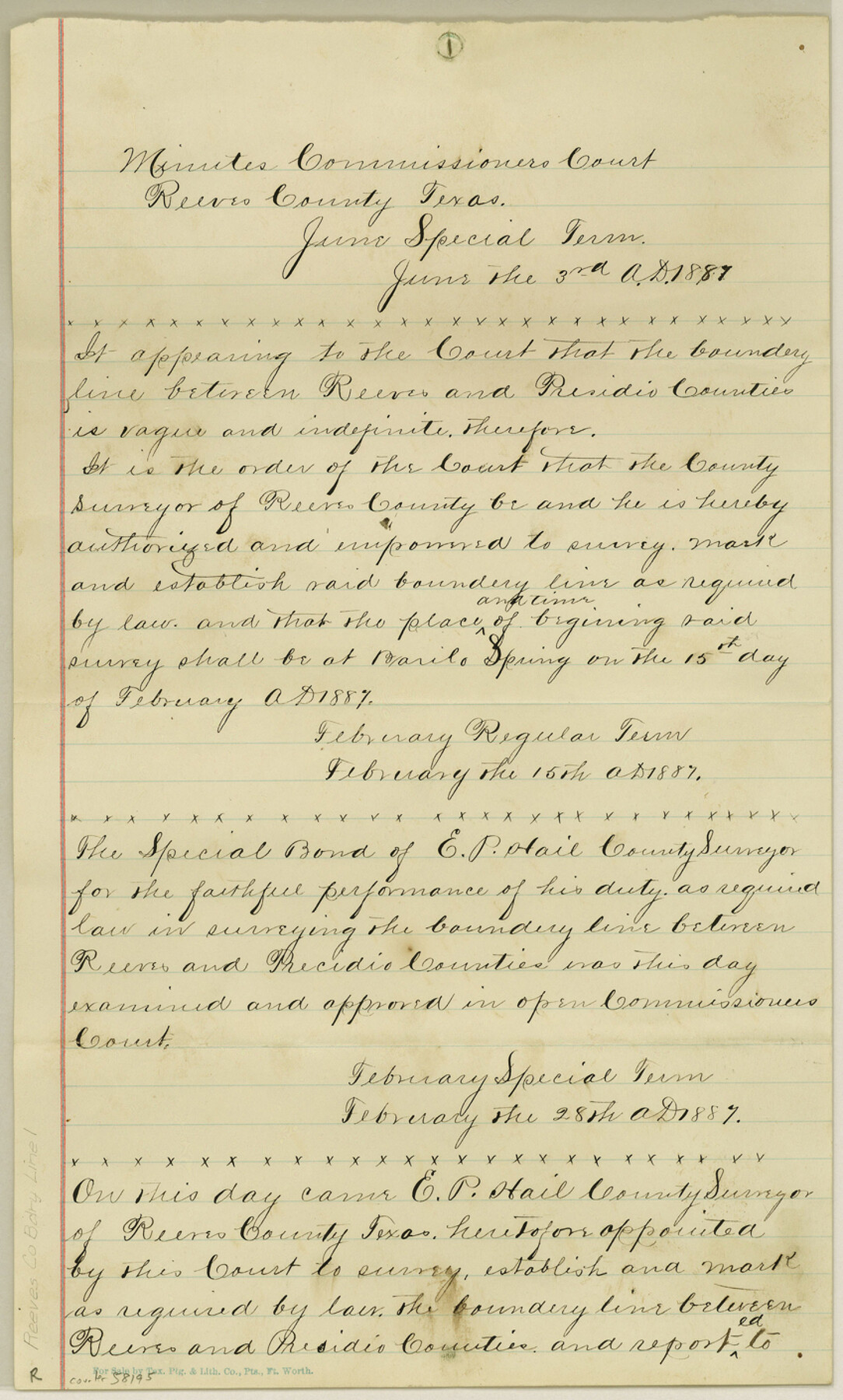
Reeves County Boundary File 1
[Court Order, Surveyor's Report, and Fieldnotes of the Boundary line between Presidio and Reeves Counties
-
Map/Doc
58195
-
Collection
General Map Collection
-
Counties
Reeves
-
Subjects
County Boundaries
-
Height x Width
14.1 x 8.5 inches
35.8 x 21.6 cm
Part of: General Map Collection
Upton County Working Sketch 23

Print $20.00
- Digital $50.00
Upton County Working Sketch 23
1953
Size 21.4 x 20.0 inches
Map/Doc 69519
Briscoe County Sketch File L

Print $40.00
- Digital $50.00
Briscoe County Sketch File L
1935
Size 30.4 x 27.4 inches
Map/Doc 11009
Map of subdivision of submerged land in the Gulf of Mexico fronting on Matagorda Island and Peninsula

Print $40.00
- Digital $50.00
Map of subdivision of submerged land in the Gulf of Mexico fronting on Matagorda Island and Peninsula
1940
Size 28.2 x 61.3 inches
Map/Doc 2929
Galveston County NRC Article 33.136 Sketch 55B

Print $24.00
- Digital $50.00
Galveston County NRC Article 33.136 Sketch 55B
2007
Size 24.0 x 36.0 inches
Map/Doc 94666
Liberty County Working Sketch 43

Print $20.00
- Digital $50.00
Liberty County Working Sketch 43
1953
Size 30.6 x 43.7 inches
Map/Doc 70502
Current Miscellaneous File 90

Print $18.00
- Digital $50.00
Current Miscellaneous File 90
1956
Size 11.2 x 8.8 inches
Map/Doc 74255
Kerr County Boundary File 4c

Print $4.00
- Digital $50.00
Kerr County Boundary File 4c
Size 3.7 x 12.3 inches
Map/Doc 64816
Map of the Fort Worth and Denver City Railway

Print $40.00
- Digital $50.00
Map of the Fort Worth and Denver City Railway
1873
Size 31.6 x 90.3 inches
Map/Doc 64778
Flight Mission No. DQN-3K, Frame 66, Calhoun County

Print $20.00
- Digital $50.00
Flight Mission No. DQN-3K, Frame 66, Calhoun County
1953
Size 18.7 x 22.5 inches
Map/Doc 84357
Runnels County Rolled Sketch 34

Print $20.00
- Digital $50.00
Runnels County Rolled Sketch 34
1950
Size 30.8 x 35.5 inches
Map/Doc 7521
Terrell County Rolled Sketch 52

Print $20.00
- Digital $50.00
Terrell County Rolled Sketch 52
1967
Size 26.8 x 30.5 inches
Map/Doc 7970
Webb County Working Sketch 82

Print $40.00
- Digital $50.00
Webb County Working Sketch 82
1979
Size 32.9 x 62.9 inches
Map/Doc 72449
You may also like
Val Verde County Working Sketch 79

Print $40.00
- Digital $50.00
Val Verde County Working Sketch 79
1973
Size 51.0 x 32.4 inches
Map/Doc 72214
Brewster County Rolled Sketch 115

Digital $50.00
Brewster County Rolled Sketch 115
Size 11.5 x 138.4 inches
Map/Doc 8514
Map of Lavaca County

Print $20.00
- Digital $50.00
Map of Lavaca County
1866
Size 22.3 x 23.7 inches
Map/Doc 3802
Crockett County Working Sketch 87

Print $20.00
- Digital $50.00
Crockett County Working Sketch 87
1976
Size 35.5 x 43.8 inches
Map/Doc 68420
Flight Mission No. DQO-2K, Frame 83, Galveston County

Print $20.00
- Digital $50.00
Flight Mission No. DQO-2K, Frame 83, Galveston County
1952
Size 18.8 x 22.5 inches
Map/Doc 85010
Smith County Rolled Sketch 6A2

Print $40.00
- Digital $50.00
Smith County Rolled Sketch 6A2
1934
Size 48.7 x 36.7 inches
Map/Doc 10702
The Republic County of Fort Bend. January 10, 1839

Print $20.00
The Republic County of Fort Bend. January 10, 1839
2020
Size 14.7 x 21.6 inches
Map/Doc 96138
Harris County Rolled Sketch 88

Print $20.00
- Digital $50.00
Harris County Rolled Sketch 88
1935
Size 19.2 x 22.5 inches
Map/Doc 6123
Johnson County Sketch File 1

Print $48.00
- Digital $50.00
Johnson County Sketch File 1
Size 8.0 x 6.9 inches
Map/Doc 28427
Polk County Sketch File 26

Print $12.00
- Digital $50.00
Polk County Sketch File 26
1889
Size 8.5 x 7.1 inches
Map/Doc 34183

Lampasas County Boundary File 5

Print $16.00
- Digital $50.00
Lampasas County Boundary File 5
Size 11.1 x 8.7 inches
Map/Doc 56128