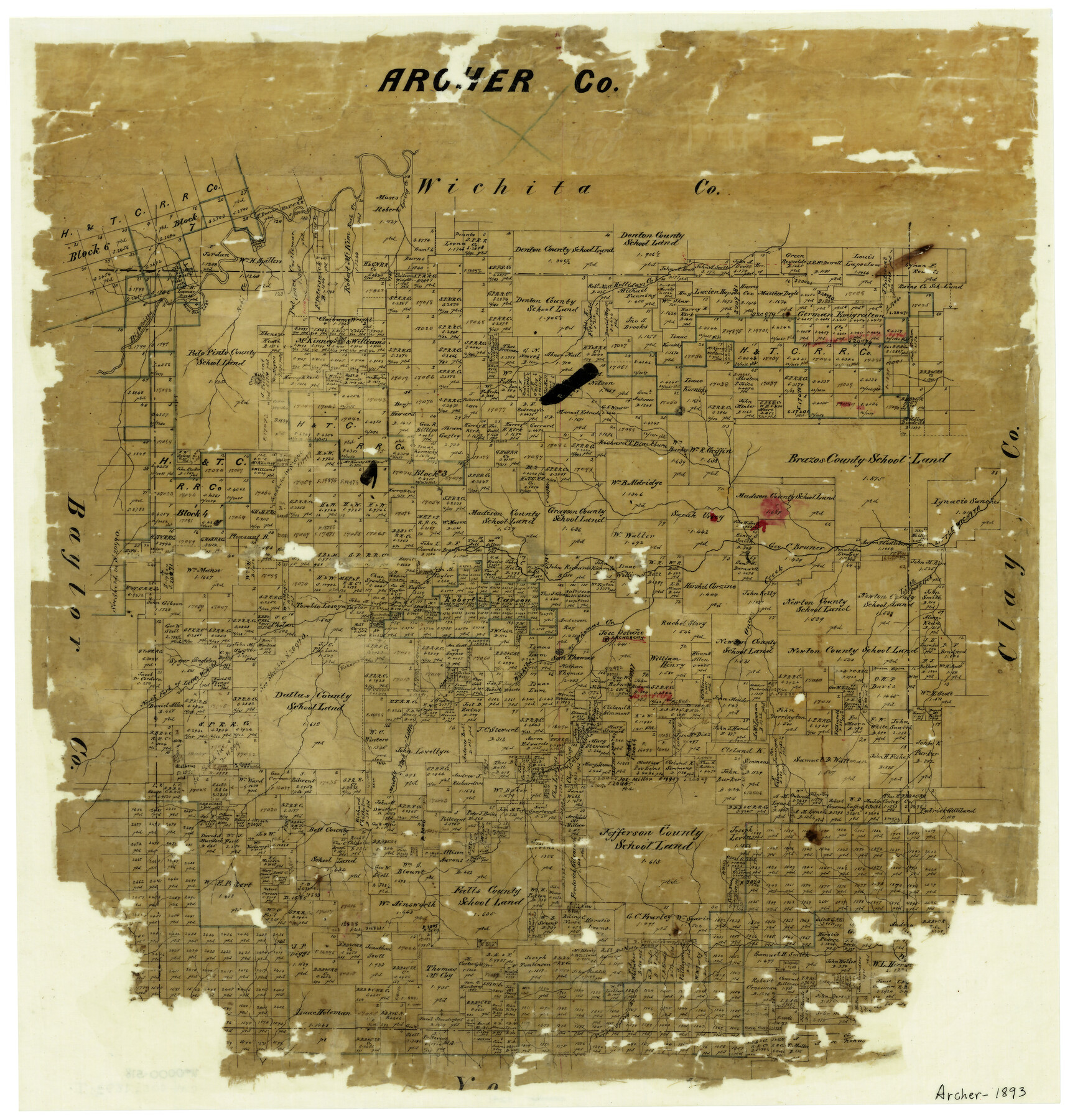
Archer County
-
Map/Doc
3241
-
Collection
General Map Collection
-
Object Dates
1893 (Creation Date)
-
People and Organizations
Texas General Land Office (Publisher)
-
Counties
Archer
-
Subjects
County
-
Height x Width
20.5 x 19.6 inches
52.1 x 49.8 cm
-
Features
Little Post Oak Creek
Turkey Spring Branch of Trinity River
North Prong of Trinity River
Bob's Creek
Valley Creek
Rush Creek
Middle Fork of Little Wichita River
South Fork of Little Wichita
Kickapoo Creek
North Fork of Little Wichita River
Archer City
Spring Creek
Onion Creek
Thomas Creek
San Thomas
Little Wichita River
Rye Hill
Corn Hill
Big Wichita River
Horse Shoe Lake
Hollidays Creek
Part of: General Map Collection
[Surveys along the Lavaca River]
![25, [Surveys along the Lavaca River], General Map Collection](https://historictexasmaps.com/wmedia_w700/maps/25.tif.jpg)
Print $2.00
- Digital $50.00
[Surveys along the Lavaca River]
1833
Size 12.9 x 8.9 inches
Map/Doc 25
Kleberg County Rolled Sketch 10-14

Print $20.00
- Digital $50.00
Kleberg County Rolled Sketch 10-14
1951
Size 38.0 x 33.2 inches
Map/Doc 9404
[F. W. & D. C. Ry. Co. Alignment and Right of Way Map, Clay County]
![64724, [F. W. & D. C. Ry. Co. Alignment and Right of Way Map, Clay County], General Map Collection](https://historictexasmaps.com/wmedia_w700/maps/64724-1.tif.jpg)
Print $20.00
- Digital $50.00
[F. W. & D. C. Ry. Co. Alignment and Right of Way Map, Clay County]
1927
Size 18.5 x 11.7 inches
Map/Doc 64724
No. 3 Chart of Channel connecting Corpus Christi Bay with Aransas Bay, Texas

Print $20.00
- Digital $50.00
No. 3 Chart of Channel connecting Corpus Christi Bay with Aransas Bay, Texas
1878
Size 18.3 x 28.0 inches
Map/Doc 72773
Tyler County Sketch File 30

Print $4.00
- Digital $50.00
Tyler County Sketch File 30
1989
Size 14.3 x 8.8 inches
Map/Doc 38721
Medina County Working Sketch 26

Print $20.00
- Digital $50.00
Medina County Working Sketch 26
1985
Size 30.6 x 30.5 inches
Map/Doc 70941
Kerr County Sketch File 24

Print $20.00
- Digital $50.00
Kerr County Sketch File 24
1967
Size 15.7 x 21.6 inches
Map/Doc 11923
Culberson County Working Sketch 19

Print $20.00
- Digital $50.00
Culberson County Working Sketch 19
1933
Size 30.0 x 43.6 inches
Map/Doc 68471
Marion County Rolled Sketch 10

Print $20.00
- Digital $50.00
Marion County Rolled Sketch 10
2023
Size 24.1 x 36.9 inches
Map/Doc 97192
Coke County Rolled Sketch 12A

Print $20.00
- Digital $50.00
Coke County Rolled Sketch 12A
1949
Size 21.1 x 23.4 inches
Map/Doc 5513
Montgomery County Working Sketch 11

Print $20.00
- Digital $50.00
Montgomery County Working Sketch 11
1933
Size 25.2 x 17.7 inches
Map/Doc 71118
Wise County Sketch File 21

Print $4.00
- Digital $50.00
Wise County Sketch File 21
1860
Size 5.6 x 7.9 inches
Map/Doc 40564
You may also like
Chambers County Sketch File 16

Print $4.00
- Digital $50.00
Chambers County Sketch File 16
Size 7.9 x 12.7 inches
Map/Doc 17566
Cameron County Sketch File 15

Print $26.00
- Digital $50.00
Cameron County Sketch File 15
1999
Size 11.2 x 8.7 inches
Map/Doc 17320
Midland County Rolled Sketch REE

Print $20.00
- Digital $50.00
Midland County Rolled Sketch REE
1937
Size 27.1 x 24.3 inches
Map/Doc 6771
[Sketch for Mineral Application 13271- Trinity River]
![65627, [Sketch for Mineral Application 13271- Trinity River], General Map Collection](https://historictexasmaps.com/wmedia_w700/maps/65627.tif.jpg)
Print $40.00
- Digital $50.00
[Sketch for Mineral Application 13271- Trinity River]
1925
Size 63.4 x 25.0 inches
Map/Doc 65627
![91462, [Block B7], Twichell Survey Records](https://historictexasmaps.com/wmedia_w700/maps/91462-1.tif.jpg)
[H. & G. N. RR. Co. Block 1]
![90888, [H. & G. N. RR. Co. Block 1], Twichell Survey Records](https://historictexasmaps.com/wmedia_w700/maps/90888-1.tif.jpg)
Print $20.00
- Digital $50.00
[H. & G. N. RR. Co. Block 1]
Size 37.1 x 43.6 inches
Map/Doc 90888
The Continent and Islands of the West Indies

Print $20.00
The Continent and Islands of the West Indies
1804
Size 22.8 x 26.0 inches
Map/Doc 79318
Shackelford County Sketch File 4

Print $40.00
- Digital $50.00
Shackelford County Sketch File 4
Size 38.5 x 53.7 inches
Map/Doc 10600
Right of Way & Track Map Houston & Brazos Valley Ry. operated by Houston & Brazos Valley Ry. Co., Hoskins Mound Branch

Print $40.00
- Digital $50.00
Right of Way & Track Map Houston & Brazos Valley Ry. operated by Houston & Brazos Valley Ry. Co., Hoskins Mound Branch
1924
Size 25.3 x 56.4 inches
Map/Doc 64609
San Augustine County Sketch File 7

Print $4.00
San Augustine County Sketch File 7
1858
Size 7.0 x 8.2 inches
Map/Doc 35646
Sulphur River, Talco Sheet

Print $20.00
- Digital $50.00
Sulphur River, Talco Sheet
1917
Size 24.6 x 43.7 inches
Map/Doc 65160
Coleman County Sketch File 45a

Print $4.00
- Digital $50.00
Coleman County Sketch File 45a
1897
Size 9.8 x 6.2 inches
Map/Doc 18791