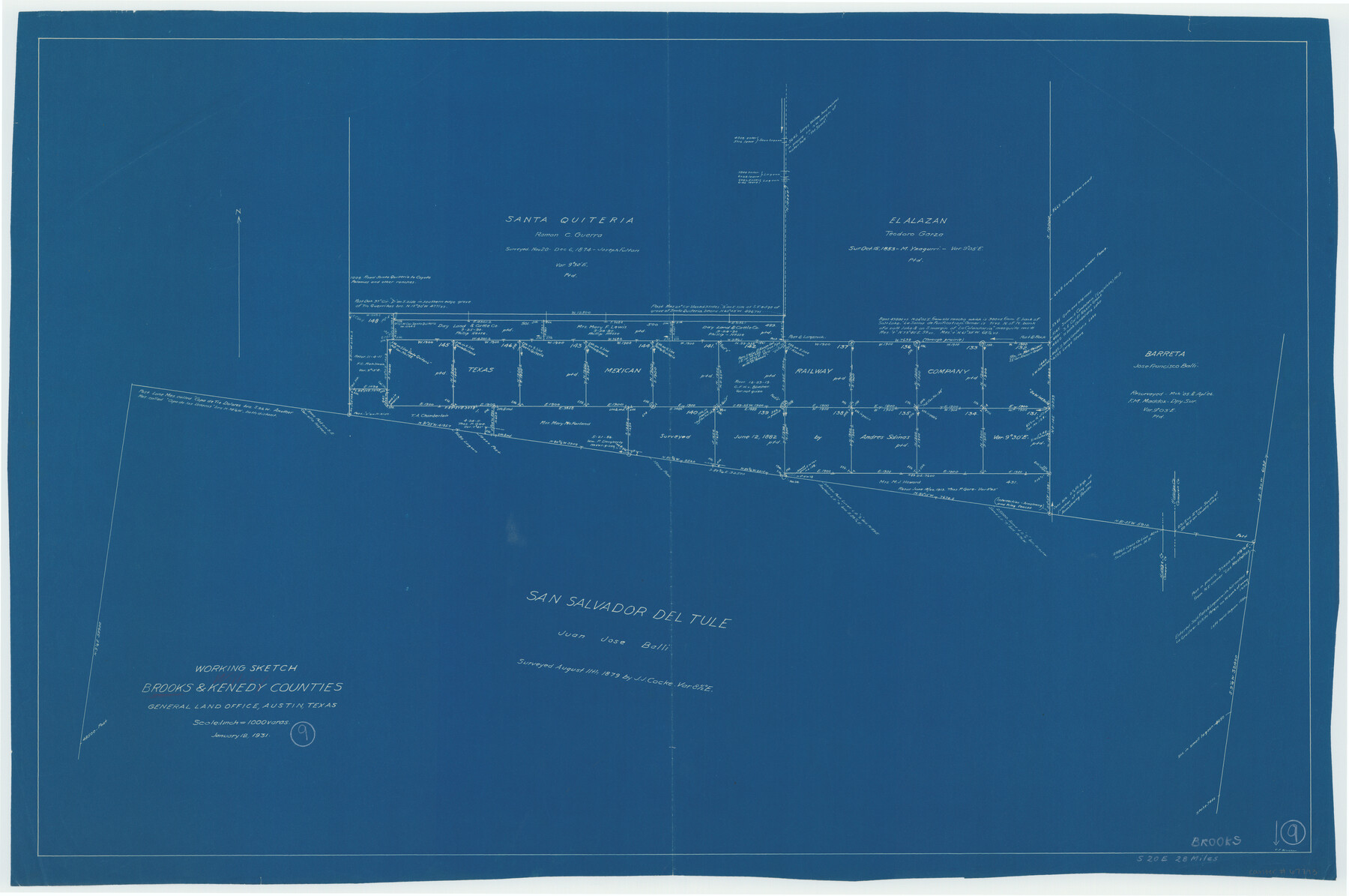
Brooks County Working Sketch 9
-
Map/Doc
67793
-
Collection
General Map Collection
-
Object Dates
1/12/1931 (Creation Date)
-
Counties
Brooks Kenedy
-
Subjects
Surveying Working Sketch
-
Height x Width
25.7 x 38.7 inches
65.3 x 98.3 cm
-
Scale
1" = 1000 varas
Part of: General Map Collection
Upton County Sketch File 7

Print $4.00
- Digital $50.00
Upton County Sketch File 7
Size 14.4 x 8.9 inches
Map/Doc 38820
Limestone County Working Sketch 24

Print $20.00
- Digital $50.00
Limestone County Working Sketch 24
1980
Size 28.9 x 31.6 inches
Map/Doc 70574
United States Gulf Coast - from Galveston to the Rio Grande

Print $20.00
- Digital $50.00
United States Gulf Coast - from Galveston to the Rio Grande
1915
Size 26.3 x 18.3 inches
Map/Doc 72731
Old Miscellaneous File 30

Print $16.00
- Digital $50.00
Old Miscellaneous File 30
1845
Size 13.3 x 8.2 inches
Map/Doc 75740
Archer County Working Sketch 10a

Print $20.00
- Digital $50.00
Archer County Working Sketch 10a
1924
Size 25.9 x 40.6 inches
Map/Doc 67150
Starr County Sketch File 45

Print $6.00
- Digital $50.00
Starr County Sketch File 45
1945
Size 14.3 x 8.7 inches
Map/Doc 36999
Burnet County Sketch File 40

Print $4.00
- Digital $50.00
Burnet County Sketch File 40
Size 14.2 x 8.6 inches
Map/Doc 16755
Lipscomb County Boundary File 1

Print $16.00
- Digital $50.00
Lipscomb County Boundary File 1
Size 9.0 x 8.0 inches
Map/Doc 56307
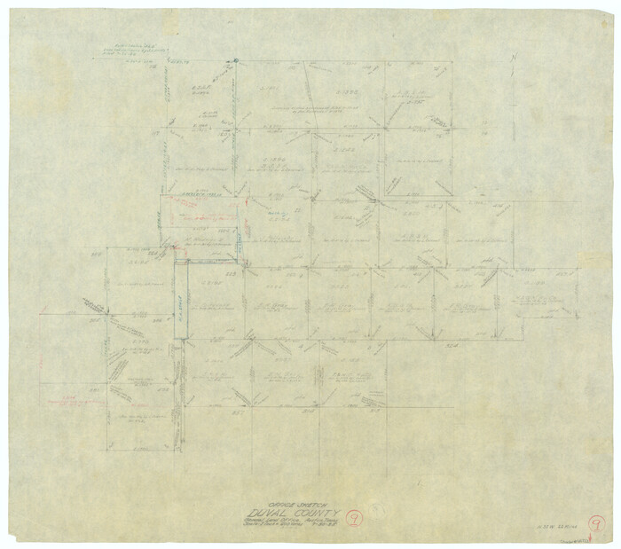
Duval County Working Sketch 9
Print $20.00
- Digital $50.00
Duval County Working Sketch 9
1935
Size 25.8 x 29.1 inches
Map/Doc 68722
Maps of Gulf Intracoastal Waterway, Texas - Sabine River to the Rio Grande and connecting waterways including ship channels

Print $20.00
- Digital $50.00
Maps of Gulf Intracoastal Waterway, Texas - Sabine River to the Rio Grande and connecting waterways including ship channels
1966
Size 14.6 x 22.2 inches
Map/Doc 61971
Hopkins County Working Sketch 5

Print $20.00
- Digital $50.00
Hopkins County Working Sketch 5
1960
Size 21.8 x 20.5 inches
Map/Doc 66230
Uvalde County

Print $20.00
- Digital $50.00
Uvalde County
1915
Size 42.9 x 46.2 inches
Map/Doc 63091
You may also like
Tom Green County Rolled Sketch 48

Print $20.00
- Digital $50.00
Tom Green County Rolled Sketch 48
1884
Size 14.3 x 22.7 inches
Map/Doc 8009
Zapata County Sketch File 16

Print $6.00
- Digital $50.00
Zapata County Sketch File 16
Size 14.5 x 8.8 inches
Map/Doc 40957
Turner 23 Acres in Lee County

Print $20.00
- Digital $50.00
Turner 23 Acres in Lee County
Size 27.0 x 20.2 inches
Map/Doc 91081
The Republic County of Liberty. December 29, 1845

Print $20.00
The Republic County of Liberty. December 29, 1845
2020
Size 19.9 x 21.7 inches
Map/Doc 96213
Smith County Working Sketch 8

Print $20.00
- Digital $50.00
Smith County Working Sketch 8
1941
Size 28.9 x 22.7 inches
Map/Doc 63893
Dimmit County Sketch File 27

Print $20.00
- Digital $50.00
Dimmit County Sketch File 27
Size 16.5 x 18.3 inches
Map/Doc 11349
Guadalupe County Working Sketch 5

Print $3.00
- Digital $50.00
Guadalupe County Working Sketch 5
1940
Size 15.2 x 10.9 inches
Map/Doc 63314
Medina County Sketch File 2

Print $12.00
- Digital $50.00
Medina County Sketch File 2
Size 7.5 x 12.5 inches
Map/Doc 31439
Flight Mission No. DCL-4C, Frame 145, Kenedy County

Print $20.00
- Digital $50.00
Flight Mission No. DCL-4C, Frame 145, Kenedy County
1943
Size 18.6 x 22.4 inches
Map/Doc 85823
[Capitol Leagues in Southwest Hartley and Northwest Oldham Counties]
![90723, [Capitol Leagues in Southwest Hartley and Northwest Oldham Counties], Twichell Survey Records](https://historictexasmaps.com/wmedia_w700/maps/90723-1.tif.jpg)
Print $20.00
- Digital $50.00
[Capitol Leagues in Southwest Hartley and Northwest Oldham Counties]
Size 13.8 x 18.0 inches
Map/Doc 90723
Culberson County Working Sketch 2

Print $20.00
- Digital $50.00
Culberson County Working Sketch 2
Size 27.7 x 18.7 inches
Map/Doc 68454
Flight Mission No. CRC-4R, Frame 107, Chambers County

Print $20.00
- Digital $50.00
Flight Mission No. CRC-4R, Frame 107, Chambers County
1956
Size 18.8 x 22.4 inches
Map/Doc 84904