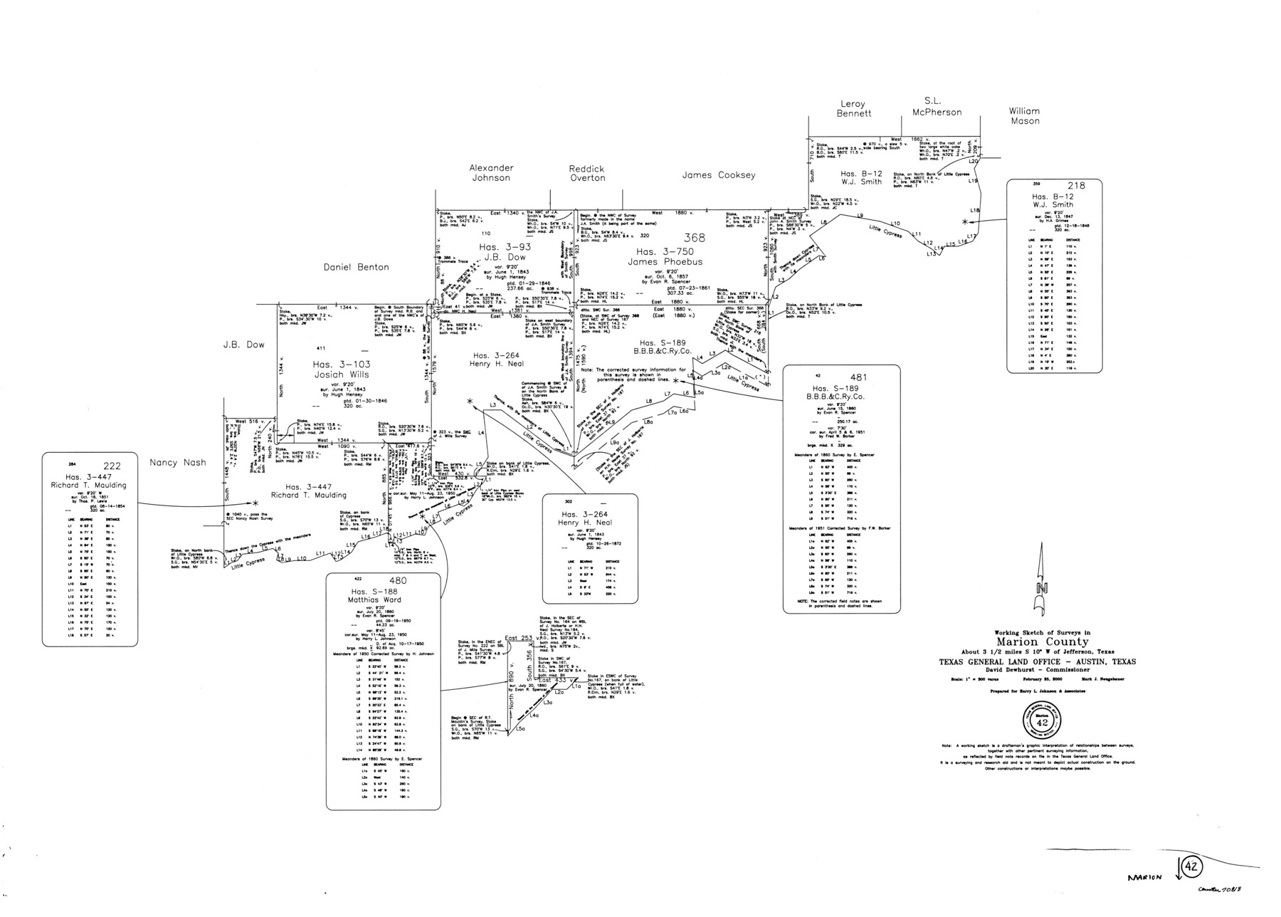
Marion County Working Sketch 42
-
Map/Doc
70818
-
Collection
General Map Collection
-
Object Dates
2/25/2000 (Creation Date)
-
People and Organizations
Mark Neugebauer (Draftsman)
-
Counties
Marion
-
Subjects
Surveying Working Sketch
-
Height x Width
29.6 x 41.4 inches
75.2 x 105.2 cm
-
Scale
1" = 300 varas
Part of: General Map Collection
[Surveys in the Jefferson District along Big Sandy Creek]
![100, [Surveys in the Jefferson District along Big Sandy Creek], General Map Collection](https://historictexasmaps.com/wmedia_w700/maps/100.tif.jpg)
Print $2.00
- Digital $50.00
[Surveys in the Jefferson District along Big Sandy Creek]
1841
Size 9.5 x 8.1 inches
Map/Doc 100
Culberson County Working Sketch 69

Print $40.00
- Digital $50.00
Culberson County Working Sketch 69
1975
Size 49.4 x 32.2 inches
Map/Doc 68523
Ward County Working Sketch 12

Print $20.00
- Digital $50.00
Ward County Working Sketch 12
1947
Size 23.4 x 22.7 inches
Map/Doc 72318
Flight Mission No. DCL-7C, Frame 118, Kenedy County

Print $20.00
- Digital $50.00
Flight Mission No. DCL-7C, Frame 118, Kenedy County
1943
Size 18.4 x 22.3 inches
Map/Doc 86083
Pecos County Rolled Sketch 115

Print $20.00
- Digital $50.00
Pecos County Rolled Sketch 115
1943
Size 24.0 x 21.6 inches
Map/Doc 7257
Map of the United States of Mexico drawn and compiled from the latest Mexican and United States Government authorities, and other reliable sources

Print $20.00
- Digital $50.00
Map of the United States of Mexico drawn and compiled from the latest Mexican and United States Government authorities, and other reliable sources
1895
Size 17.3 x 24.8 inches
Map/Doc 94083
Map of Llano County

Print $20.00
- Digital $50.00
Map of Llano County
1871
Size 17.0 x 20.5 inches
Map/Doc 3825
Pecos County Sketch File 53

Print $20.00
- Digital $50.00
Pecos County Sketch File 53
Size 18.0 x 38.9 inches
Map/Doc 10569
Presidio County Rolled Sketch 43

Print $20.00
- Digital $50.00
Presidio County Rolled Sketch 43
1907
Size 31.5 x 19.7 inches
Map/Doc 7340
Refugio County Working Sketch 18

Print $20.00
- Digital $50.00
Refugio County Working Sketch 18
2013
Size 24.0 x 29.3 inches
Map/Doc 93622
Bowie County Sketch File 8

Print $42.00
- Digital $50.00
Bowie County Sketch File 8
1927
Size 8.9 x 3.8 inches
Map/Doc 14872
McLennan County Boundary File 1

Print $80.00
- Digital $50.00
McLennan County Boundary File 1
Size 19.4 x 12.3 inches
Map/Doc 56937
You may also like
Map of Armstrong County

Print $20.00
- Digital $50.00
Map of Armstrong County
1886
Size 23.0 x 18.6 inches
Map/Doc 3244
Polk County Working Sketch 31

Print $20.00
- Digital $50.00
Polk County Working Sketch 31
1960
Size 18.2 x 24.4 inches
Map/Doc 71647
Townsite Map of Chipley, Cochran County, Texas

Print $20.00
- Digital $50.00
Townsite Map of Chipley, Cochran County, Texas
1925
Size 19.4 x 29.3 inches
Map/Doc 92524
Duval County Sketch File 87

Print $12.00
- Digital $50.00
Duval County Sketch File 87
1991
Size 11.0 x 8.5 inches
Map/Doc 21549
General Highway Map. Detail of Cities and Towns in Travis County, Texas. City Map, Austin and vicinity, Travis County, Texas

Print $20.00
General Highway Map. Detail of Cities and Towns in Travis County, Texas. City Map, Austin and vicinity, Travis County, Texas
1961
Size 18.1 x 24.7 inches
Map/Doc 79687
Leon County Working Sketch 10

Print $20.00
- Digital $50.00
Leon County Working Sketch 10
1951
Size 21.5 x 17.3 inches
Map/Doc 70409
Kinney County Sketch File A1

Print $38.00
- Digital $50.00
Kinney County Sketch File A1
1905
Size 35.4 x 27.6 inches
Map/Doc 11952
Official Map, City of Lubbock, Lubbock County, Texas

Print $20.00
- Digital $50.00
Official Map, City of Lubbock, Lubbock County, Texas
1927
Size 24.1 x 32.9 inches
Map/Doc 91329

Missouri, Kansas & Texas Ry. thro' Denison and the beautiful Indian Territory

Print $20.00
- Digital $50.00
Missouri, Kansas & Texas Ry. thro' Denison and the beautiful Indian Territory
1877
Size 15.7 x 21.7 inches
Map/Doc 95805
Starr County Working Sketch 28

Print $20.00
- Digital $50.00
Starr County Working Sketch 28
2004
Size 28.0 x 39.6 inches
Map/Doc 83010
Leon County Sketch File 28

Print $8.00
- Digital $50.00
Leon County Sketch File 28
1951
Size 11.2 x 8.7 inches
Map/Doc 29821