Nueces County Rolled Sketch 113A
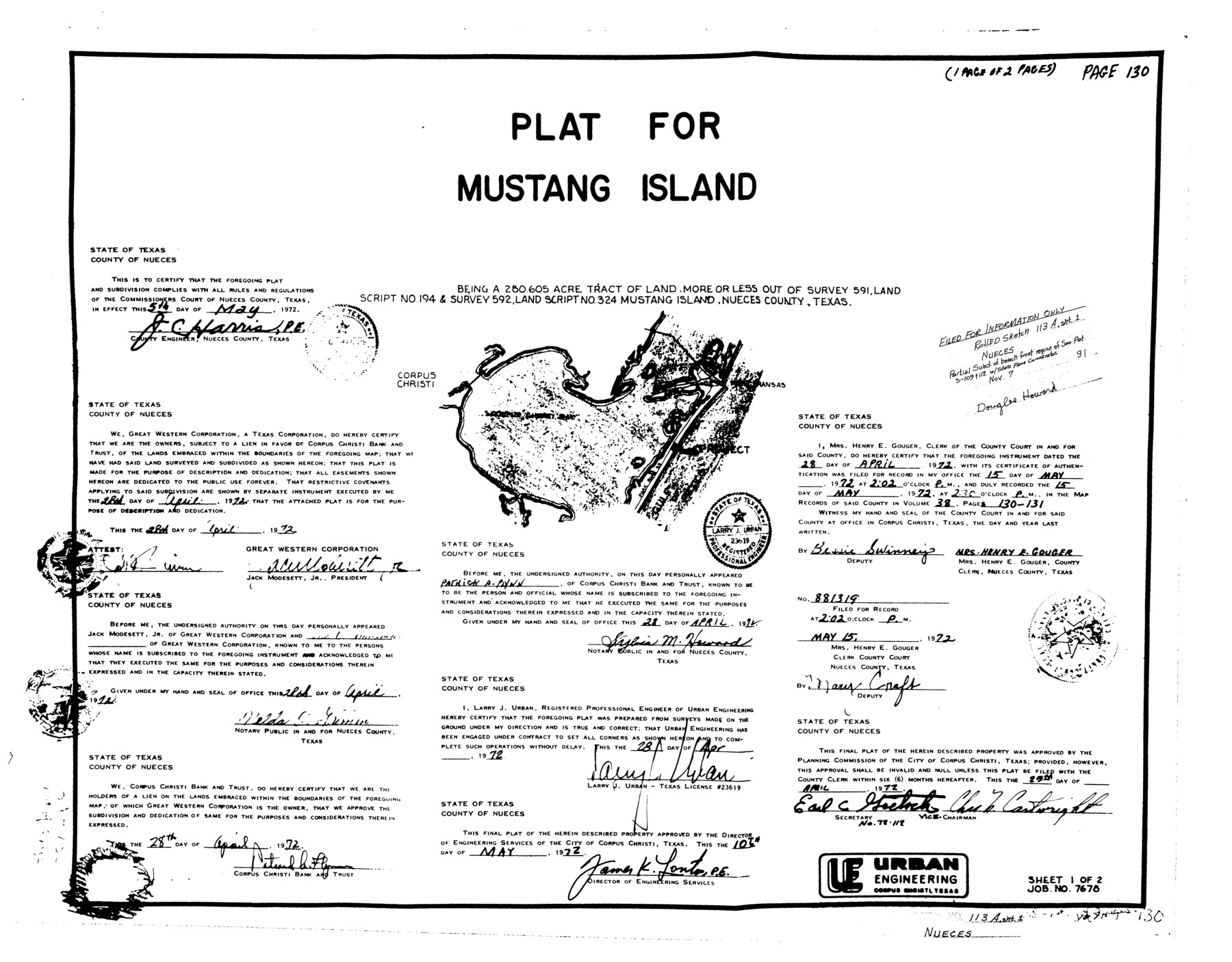
Plat for Mustang Island being a 280.605 acre tract of land more or less out of survey 591, land script no. 194 & survey 592, land script no. 324, Mustang Island, Nueces County, Texas
-
Map/Doc
7121
-
Collection
General Map Collection
-
Object Dates
1972/4/28 (Creation Date)
1991/11/7 (File Date)
-
People and Organizations
Larry J. Urban (Surveyor/Engineer)
-
Counties
Nueces
-
Subjects
Surveying Rolled Sketch
-
Height x Width
19.1 x 24.4 inches
48.5 x 62.0 cm
-
Comments
Sheet 1 of 2. See Nueces County Rolled Sketch 113A (7122) for sheet 2. Filed for information only.
Related maps
Nueces County Rolled Sketch 113A

Print $20.00
- Digital $50.00
Nueces County Rolled Sketch 113A
1972
Size 18.6 x 23.3 inches
Map/Doc 7122
Part of: General Map Collection
Duval County Working Sketch 1

Print $20.00
- Digital $50.00
Duval County Working Sketch 1
Size 24.6 x 36.4 inches
Map/Doc 76442
Jasper County Working Sketch 10

Print $20.00
- Digital $50.00
Jasper County Working Sketch 10
1917
Size 17.4 x 22.7 inches
Map/Doc 66472
Flight Mission No. CLL-3N, Frame 36, Willacy County

Print $20.00
- Digital $50.00
Flight Mission No. CLL-3N, Frame 36, Willacy County
1954
Size 18.4 x 22.2 inches
Map/Doc 87094
Jim Wells County Working Sketch 12

Print $20.00
- Digital $50.00
Jim Wells County Working Sketch 12
1962
Size 19.2 x 15.6 inches
Map/Doc 66610
Flight Mission No. CRK-5P, Frame 160, Refugio County

Print $20.00
- Digital $50.00
Flight Mission No. CRK-5P, Frame 160, Refugio County
1956
Size 18.6 x 22.4 inches
Map/Doc 86941
Mason County Boundary File 4

Print $38.00
- Digital $50.00
Mason County Boundary File 4
Size 8.7 x 4.0 inches
Map/Doc 56852
Bexar County Sketch File 55

Print $20.00
- Digital $50.00
Bexar County Sketch File 55
1838
Size 13.3 x 8.3 inches
Map/Doc 14560
Crane County Sketch File 17

Print $6.00
- Digital $50.00
Crane County Sketch File 17
1927
Size 11.1 x 8.4 inches
Map/Doc 19581
Flight Mission No. DCL-3C, Frame 155, Kenedy County

Print $20.00
- Digital $50.00
Flight Mission No. DCL-3C, Frame 155, Kenedy County
1943
Size 18.6 x 22.4 inches
Map/Doc 85803
Crockett County Rolled Sketch 53

Print $20.00
- Digital $50.00
Crockett County Rolled Sketch 53
1942
Size 17.5 x 36.8 inches
Map/Doc 5598

Morris County Rolled Sketch 2A

Print $20.00
- Digital $50.00
Morris County Rolled Sketch 2A
Size 22.5 x 17.6 inches
Map/Doc 10230
You may also like
G&H Blocks Gaines Co. Resurvey 1915

Print $40.00
- Digital $50.00
G&H Blocks Gaines Co. Resurvey 1915
1915
Size 56.8 x 31.3 inches
Map/Doc 89632
Dallam County Boundary File 4

Print $80.00
- Digital $50.00
Dallam County Boundary File 4
Size 9.4 x 49.8 inches
Map/Doc 52082
Webb County Boundary File 3a

Print $10.00
- Digital $50.00
Webb County Boundary File 3a
Size 14.2 x 8.7 inches
Map/Doc 59753
Kaufman County Working Sketch 9

Print $20.00
- Digital $50.00
Kaufman County Working Sketch 9
1988
Size 35.9 x 29.8 inches
Map/Doc 66672
Fort Bend Co.

Print $20.00
- Digital $50.00
Fort Bend Co.
1931
Size 40.2 x 41.8 inches
Map/Doc 95500
Coke County Rolled Sketch 16

Print $20.00
- Digital $50.00
Coke County Rolled Sketch 16
1950
Size 44.0 x 34.3 inches
Map/Doc 8630
Block 2 T. & N. Ry. Co., Block 97 H. T. C. Ry. Co.

Print $40.00
- Digital $50.00
Block 2 T. & N. Ry. Co., Block 97 H. T. C. Ry. Co.
1888
Size 41.5 x 48.1 inches
Map/Doc 89874
Concho County Sketch File 6

Print $8.00
- Digital $50.00
Concho County Sketch File 6
1858
Size 13.3 x 8.3 inches
Map/Doc 19127
Karnes County Sketch File 6

Print $4.00
- Digital $50.00
Karnes County Sketch File 6
1858
Size 7.7 x 8.1 inches
Map/Doc 28557
General Highway Map, Randall County, Texas

Print $20.00
General Highway Map, Randall County, Texas
1961
Size 18.1 x 24.5 inches
Map/Doc 79635
Flight Mission No. DAG-24K, Frame 45, Matagorda County

Print $20.00
- Digital $50.00
Flight Mission No. DAG-24K, Frame 45, Matagorda County
1953
Size 18.6 x 22.2 inches
Map/Doc 86532
Cass County Texas

Print $20.00
- Digital $50.00
Cass County Texas
1879
Size 17.7 x 21.3 inches
Map/Doc 4516