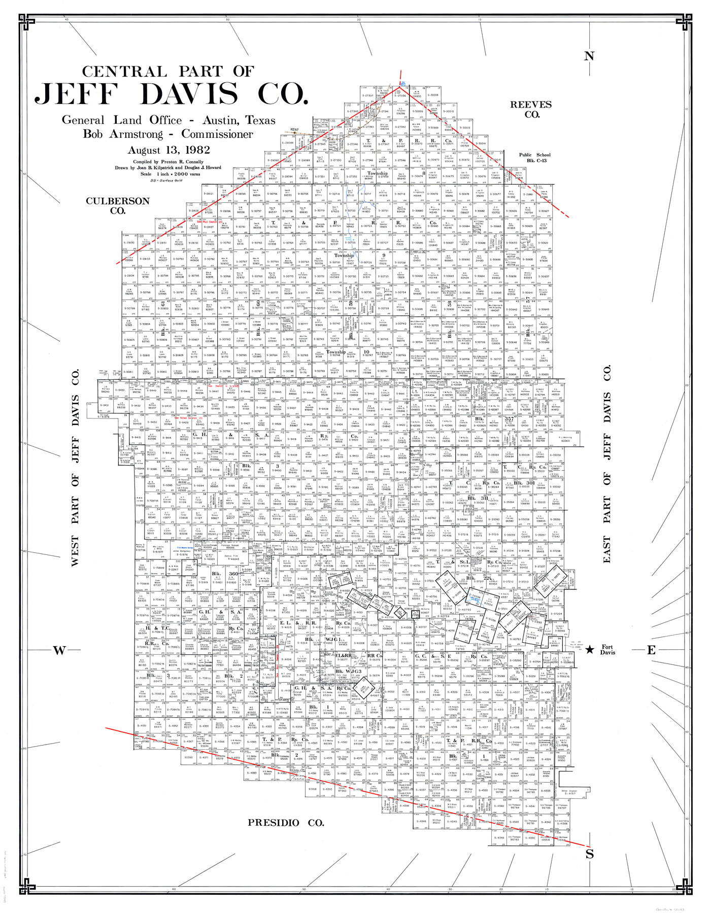
Central Part of Jeff Davis Co.
- 
                          Map/Doc
73193
 - 
                            Collection
General Map Collection
 - 
                            Object Dates
8/13/1982 (Creation Date)
 - 
                            People and Organizations
Preston R. Connally (Compiler)
Bob Armstrong (GLO Commissioner)
Douglas Howard (Draftsman)
Joan Kilpatrick (Draftsman)
 - 
                            Counties
Jeff Davis
 - 
                            Subjects
County
 - 
                            Height x Width
55.4 x 43.9 inches
140.7 x 111.5 cm
 - 
                            Scale
1" = 2000 varas
 - 
                            Comments
Leroy lettered.
 - 
                            Features
San Martin Spring
T&P
Kent
Apache Springs
El Muerto Springs
Fort Davis
Agua Blanco Spring
 
Part of: General Map Collection
            Flight Mission No. DQN-1K, Frame 158, Calhoun County


                                            Print $20.00                    
                                             -                         Digital $50.00                                    
                Flight Mission No. DQN-1K, Frame 158, Calhoun County
1953
Size 18.6 x 22.3 inches
                                Map/Doc 84217
            
            Chambers County Sketch File 10b


                                            Print $4.00                    
                                             -                         Digital $50.00                                    
                Chambers County Sketch File 10b
1841
Size 9.6 x 8.2 inches
                                Map/Doc 17552
            
            Garza County Sketch File E


                                            Print $20.00                    
                                             -                         Digital $50.00                                    
                Garza County Sketch File E
Size 16.0 x 15.7 inches
                                Map/Doc 11552
            
            Titus County Sketch File 6


                                            Print $6.00                    
                                             -                         Digital $50.00                                    
                Titus County Sketch File 6
1853
Size 16.5 x 8.3 inches
                                Map/Doc 38140
            
            Hutchinson County Rolled Sketch 40


                                            Print $20.00                    
                                             -                         Digital $50.00                                    
                Hutchinson County Rolled Sketch 40
1981
Size 26.8 x 37.4 inches
                                Map/Doc 6303
            
            Brooks County Boundary File 1


                                            Print $54.00                    
                                             -                         Digital $50.00                                    
                Brooks County Boundary File 1
Size 9.0 x 8.6 inches
                                Map/Doc 50809
            
            Maps of Gulf Intracoastal Waterway, Texas - Sabine River to the Rio Grande and connecting waterways including ship channels


                                            Print $20.00                    
                                             -                         Digital $50.00                                    
                Maps of Gulf Intracoastal Waterway, Texas - Sabine River to the Rio Grande and connecting waterways including ship channels
1966
Size 14.6 x 22.3 inches
                                Map/Doc 61954
            
            Foard County Boundary File 5


                                            Print $20.00                    
                                             -                         Digital $50.00                                    
                Foard County Boundary File 5
Size 10.3 x 8.8 inches
                                Map/Doc 53536
            
            Zavala County Rolled Sketch 21


                                            Print $20.00                    
                                             -                         Digital $50.00                                    
                Zavala County Rolled Sketch 21
Size 27.6 x 38.4 inches
                                Map/Doc 8324
            
            Comanche County Sketch File 9


                                            Print $4.00                    
                                             -                         Digital $50.00                                    
                Comanche County Sketch File 9
1859
Size 6.0 x 9.1 inches
                                Map/Doc 19068
            
            Flight Mission No. CRK-3P, Frame 175, Refugio County


                                            Print $20.00                    
                                             -                         Digital $50.00                                    
                Flight Mission No. CRK-3P, Frame 175, Refugio County
1956
Size 18.6 x 21.7 inches
                                Map/Doc 86922
            
            Hunt County Sketch File 37


                                            Print $4.00                    
                                             -                         Digital $50.00                                    
                Hunt County Sketch File 37
Size 11.4 x 8.1 inches
                                Map/Doc 27155
            You may also like
            Flight Mission No. BRE-5P, Frame 201, Nueces County


                                            Print $20.00                    
                                             -                         Digital $50.00                                    
                Flight Mission No. BRE-5P, Frame 201, Nueces County
1956
Size 18.5 x 22.6 inches
                                Map/Doc 86841
            
            The Republic County of Brazoria. May 15, 1838


                                            Print $20.00                    
                                    
                The Republic County of Brazoria. May 15, 1838
2020
Size 14.7 x 21.8 inches
                                Map/Doc 96112
            
            Kleberg County Rolled Sketch 5


                                            Print $20.00                    
                                             -                         Digital $50.00                                    
                Kleberg County Rolled Sketch 5
Size 27.8 x 21.8 inches
                                Map/Doc 6548
            
            Section Q Tech Memorial Park, Inc.


                                            Print $20.00                    
                                             -                         Digital $50.00                                    
                Section Q Tech Memorial Park, Inc.
1950
Size 28.5 x 31.6 inches
                                Map/Doc 92349
            
            University of Texas System University Lands


                                            Print $20.00                    
                                             -                         Digital $50.00                                    
                University of Texas System University Lands
1929
Size 23.2 x 17.7 inches
                                Map/Doc 93246
            
            Harris County Boundary File 1


                                            Print $6.00                    
                                             -                         Digital $50.00                                    
                Harris County Boundary File 1
1963
Size 9.2 x 11.2 inches
                                Map/Doc 54292
            
            Lubbock County Rolled Sketch 3


                                            Print $20.00                    
                                             -                         Digital $50.00                                    
                Lubbock County Rolled Sketch 3
Size 25.0 x 38.7 inches
                                Map/Doc 9469
            
            Wood County Sketch File 7


                                            Print $17.00                    
                                             -                         Digital $50.00                                    
                Wood County Sketch File 7
1848
Size 11.9 x 7.7 inches
                                Map/Doc 40645
            
            Pecos County Rolled Sketch 116


                                            Print $20.00                    
                                             -                         Digital $50.00                                    
                Pecos County Rolled Sketch 116
Size 26.7 x 20.6 inches
                                Map/Doc 7259
            
            United States - Gulf Coast - Aransas Pass and Corpus Christi Bay with the coast to latitude 27° 12' Texas


                                            Print $20.00                    
                                             -                         Digital $50.00                                    
                United States - Gulf Coast - Aransas Pass and Corpus Christi Bay with the coast to latitude 27° 12' Texas
1913
Size 27.5 x 18.3 inches
                                Map/Doc 72794
            
            The Rand McNally New Commercial Atlas Map of Texas


                                            Print $20.00                    
                                             -                         Digital $50.00                                    
                The Rand McNally New Commercial Atlas Map of Texas
1915
Size 28.5 x 40.3 inches
                                Map/Doc 95862
            
            Map of the Texas and Pacific Railway and Connections


                                            Print $20.00                    
                                    
                Map of the Texas and Pacific Railway and Connections
1897
Size 17.7 x 36.1 inches
                                Map/Doc 76298