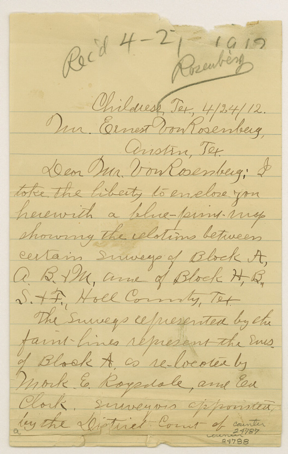
Hall County Sketch File C1
Sketch Showing the Relative Position of the Various Surveys Delineated Thereon
-
Map/Doc
24787
-
Collection
General Map Collection
-
Object Dates
1912/4/27 (File Date)
1912/4/24 (Creation Date)
-
People and Organizations
George H. Chipman (Surveyor/Engineer)
Mark E. Ragsdale (Surveyor/Engineer)
Ed Clark (Surveyor/Engineer)
-
Counties
Hall
-
Subjects
Surveying Sketch File
-
Height x Width
8.3 x 5.3 inches
21.1 x 13.5 cm
-
Medium
paper, manuscript
Part of: General Map Collection
Flight Mission No. DQN-3K, Frame 67, Calhoun County

Print $20.00
- Digital $50.00
Flight Mission No. DQN-3K, Frame 67, Calhoun County
1953
Size 18.6 x 22.3 inches
Map/Doc 84358
Map of Surveys Made for the T&PRR in Borden, Dawson, Howard & Martin Counties, Blocks 32, 33, 34, 35 & 36, Reserve West of the Colorado

Print $20.00
- Digital $50.00
Map of Surveys Made for the T&PRR in Borden, Dawson, Howard & Martin Counties, Blocks 32, 33, 34, 35 & 36, Reserve West of the Colorado
1876
Size 42.0 x 38.2 inches
Map/Doc 2231
Harris County Rolled Sketch 84

Print $20.00
- Digital $50.00
Harris County Rolled Sketch 84
1957
Size 38.7 x 31.7 inches
Map/Doc 6118
Outer Continental Shelf Leasing Maps (Louisiana Offshore Operations)

Print $20.00
- Digital $50.00
Outer Continental Shelf Leasing Maps (Louisiana Offshore Operations)
1954
Size 11.3 x 12.4 inches
Map/Doc 76117
Working Sketch No. II in Pecos County

Print $20.00
- Digital $50.00
Working Sketch No. II in Pecos County
1886
Size 31.3 x 24.1 inches
Map/Doc 3953
Colorado County Working Sketch 23

Print $20.00
- Digital $50.00
Colorado County Working Sketch 23
1967
Size 38.0 x 32.9 inches
Map/Doc 68123
Erath County Working Sketch 29

Print $20.00
- Digital $50.00
Erath County Working Sketch 29
1970
Size 25.6 x 27.4 inches
Map/Doc 69110
Liberty County Working Sketch 45

Print $20.00
- Digital $50.00
Liberty County Working Sketch 45
1953
Size 28.9 x 39.8 inches
Map/Doc 70504
Live Oak County Working Sketch 15

Print $20.00
- Digital $50.00
Live Oak County Working Sketch 15
1952
Size 23.8 x 22.6 inches
Map/Doc 70600
Lipscomb County Sketch File 3

Print $20.00
- Digital $50.00
Lipscomb County Sketch File 3
Size 36.5 x 8.4 inches
Map/Doc 10526
Flight Mission No. CRC-2R, Frame 58, Chambers County

Print $20.00
- Digital $50.00
Flight Mission No. CRC-2R, Frame 58, Chambers County
1956
Size 18.8 x 22.6 inches
Map/Doc 84729
San Patricio County Sketch File 15

Print $24.00
San Patricio County Sketch File 15
1879
Size 9.0 x 7.6 inches
Map/Doc 36051
You may also like
General Highway Map, Wilson County, Texas

Print $20.00
General Highway Map, Wilson County, Texas
1940
Size 18.2 x 24.8 inches
Map/Doc 79282

Gaines County Working Sketch 8

Print $20.00
- Digital $50.00
Gaines County Working Sketch 8
1951
Size 21.8 x 24.8 inches
Map/Doc 69308
McCulloch County Boundary File 2

Print $6.00
- Digital $50.00
McCulloch County Boundary File 2
Size 12.9 x 8.3 inches
Map/Doc 56908
Map Showing Subdivision of Mallet Land and Cattle Company's Ranch Hockley and Cochran Counties, Texas

Print $20.00
- Digital $50.00
Map Showing Subdivision of Mallet Land and Cattle Company's Ranch Hockley and Cochran Counties, Texas
1924
Size 39.4 x 30.3 inches
Map/Doc 92210
Jack County Boundary File 1

Print $26.00
- Digital $50.00
Jack County Boundary File 1
Size 12.9 x 8.2 inches
Map/Doc 55363
Map of the State of Texas [West Part]
![81921, Map of the State of Texas [West Part], General Map Collection](https://historictexasmaps.com/wmedia_w700/maps/81921.tif.jpg)
Print $40.00
- Digital $50.00
Map of the State of Texas [West Part]
1938
Size 68.7 x 38.2 inches
Map/Doc 81921
Haskell County Sketch File 19

Print $20.00
- Digital $50.00
Haskell County Sketch File 19
1902
Size 26.9 x 23.1 inches
Map/Doc 11742
Pecos County Working Sketch 63

Print $20.00
- Digital $50.00
Pecos County Working Sketch 63
1954
Size 29.5 x 33.2 inches
Map/Doc 71535
Winkler County

Print $20.00
- Digital $50.00
Winkler County
1932
Size 39.7 x 38.5 inches
Map/Doc 95678
Williamson County

Print $20.00
- Digital $50.00
Williamson County
1872
Size 18.4 x 28.2 inches
Map/Doc 4151
Controlled Mosaic by Jack Amman Photogrammetric Engineers, Inc - Sheet 31

Print $20.00
- Digital $50.00
Controlled Mosaic by Jack Amman Photogrammetric Engineers, Inc - Sheet 31
1954
Size 20.0 x 24.0 inches
Map/Doc 83484