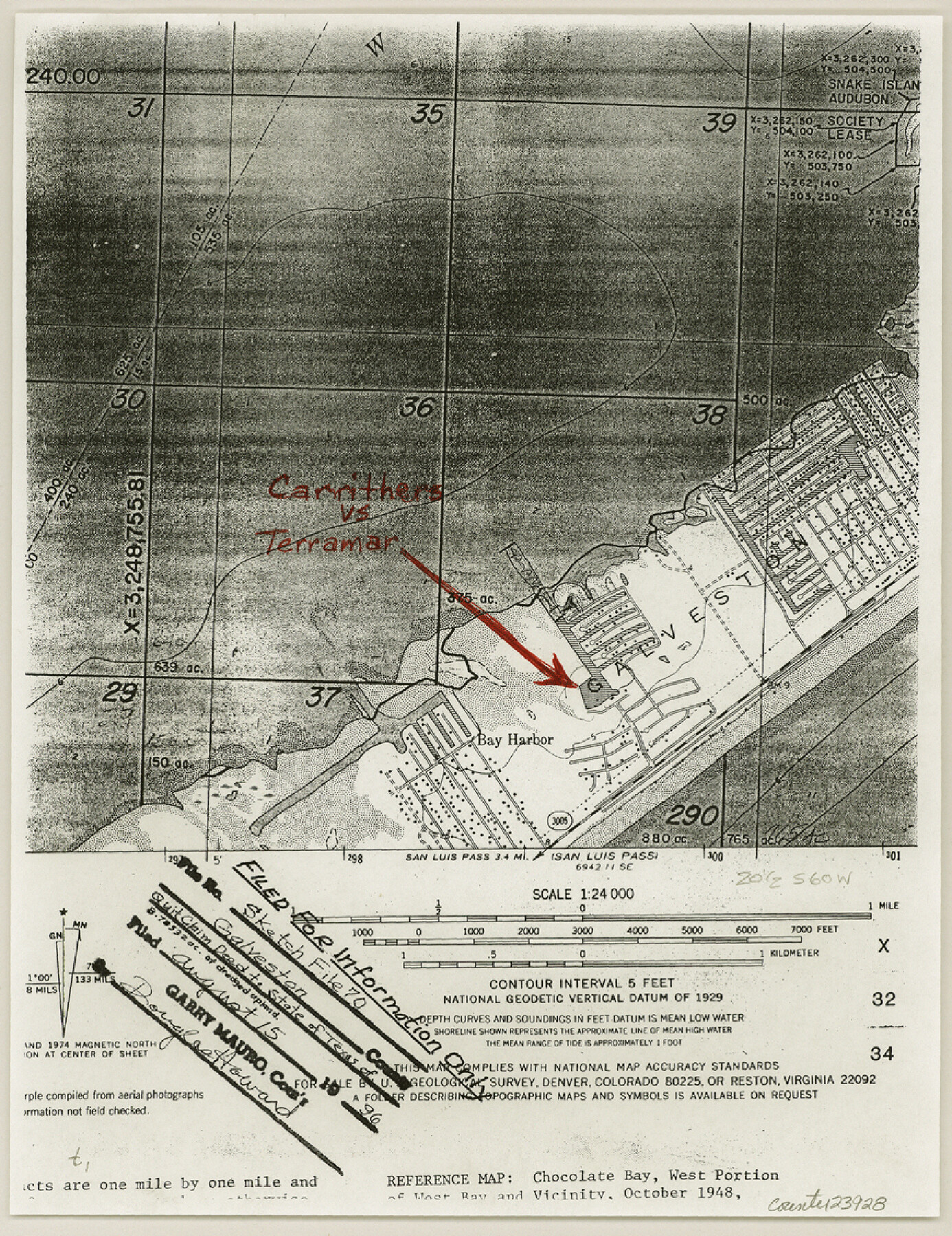
Galveston County Sketch File 70
[Quit claim deed to State of Texas of 8.78532 acres of dredged upland, out of Division 4, Section 13 of the Hall and Jones survey, A-121]
- 
                          Map/Doc
23928
 - 
                            Collection
General Map Collection
 - 
                            Object Dates
1983/3/9 (Creation Date)
1996/8/15 (File Date)
1979/1/29 (Creation Date)
 - 
                            Counties
Galveston
 - 
                            Subjects
Surveying Sketch File
 - 
                            Height x Width
11.3 x 8.7 inches
28.7 x 22.1 cm
 - 
                            Medium
paper, photocopy
 - 
                            Scale
1:24,000
 - 
                            Features
Snake Island
Bay Harbor
Galveston
Terramar Beach [Subdivision]
Gulf of Mexico
Marina Drive
Terramar Channel
Martes Street
Lunes Street
Vida Street
Laguna Drive
Cuadro Street
Obra Street
Obra Drive
Buena Street
Terramar Drive
 
Part of: General Map Collection
            Galveston/Galveston Island, Texas


            Galveston/Galveston Island, Texas
Size 18.4 x 24.2 inches
                                Map/Doc 94345
            
            Flight Mission No. CLL-1N, Frame 110, Willacy County


                                            Print $20.00                    
                                             -                         Digital $50.00                                    
                Flight Mission No. CLL-1N, Frame 110, Willacy County
1954
Size 18.5 x 22.1 inches
                                Map/Doc 87044
            
            Baylor County Working Sketch 11


                                            Print $20.00                    
                                             -                         Digital $50.00                                    
                Baylor County Working Sketch 11
1957
Size 20.0 x 47.8 inches
                                Map/Doc 67296
            
            Flight Mission No. DAG-23K, Frame 151, Matagorda County


                                            Print $20.00                    
                                             -                         Digital $50.00                                    
                Flight Mission No. DAG-23K, Frame 151, Matagorda County
1953
Size 15.9 x 15.8 inches
                                Map/Doc 86499
            
            Live Oak County Sketch File 10


                                            Print $6.00                    
                                             -                         Digital $50.00                                    
                Live Oak County Sketch File 10
1876
Size 10.0 x 15.5 inches
                                Map/Doc 30263
            
            Trinity County Working Sketch 21


                                            Print $20.00                    
                                             -                         Digital $50.00                                    
                Trinity County Working Sketch 21
1992
Size 23.1 x 23.1 inches
                                Map/Doc 69470
            
            Medina County Working Sketch 28


                                            Print $20.00                    
                                             -                         Digital $50.00                                    
                Medina County Working Sketch 28
1988
Size 32.1 x 35.3 inches
                                Map/Doc 70943
            
            Tyler County Sketch File 24


                                            Print $16.00                    
                                             -                         Digital $50.00                                    
                Tyler County Sketch File 24
1944
Size 11.2 x 9.0 inches
                                Map/Doc 38681
            
            Plat of South 1/2 of Colorado River Channel in McCulloch Co., Texas from Concho County line down river 34 mile 315 varas


                                            Print $40.00                    
                                             -                         Digital $50.00                                    
                Plat of South 1/2 of Colorado River Channel in McCulloch Co., Texas from Concho County line down river 34 mile 315 varas
1918
Size 41.5 x 104.6 inches
                                Map/Doc 2463
            
            Jefferson County Sketch File 54


                                            Print $226.00                    
                                             -                         Digital $50.00                                    
                Jefferson County Sketch File 54
1961
Size 11.0 x 8.5 inches
                                Map/Doc 28359
            
            Calhoun County Rolled Sketch 27


                                            Print $127.00                    
                                             -                         Digital $50.00                                    
                Calhoun County Rolled Sketch 27
1976
Size 10.1 x 16.0 inches
                                Map/Doc 43621
            
            Bexar County Sketch File 61


                                            Print $61.00                    
                                             -                         Digital $50.00                                    
                Bexar County Sketch File 61
2019
Size 11.0 x 8.5 inches
                                Map/Doc 95709
            You may also like
            Goliad County Sketch File 25


                                            Print $6.00                    
                                             -                         Digital $50.00                                    
                Goliad County Sketch File 25
1856
Size 12.3 x 7.8 inches
                                Map/Doc 24305
            
            Blanco County Working Sketch 13


                                            Print $20.00                    
                                             -                         Digital $50.00                                    
                Blanco County Working Sketch 13
1948
Size 42.6 x 33.6 inches
                                Map/Doc 67373
            
            The Republic County of Montgomery. January 25, 1840


                                            Print $20.00                    
                                    
                The Republic County of Montgomery. January 25, 1840
2020
Size 19.9 x 21.7 inches
                                Map/Doc 96237
            
            Ownership Map of Lynn County


                                            Print $20.00                    
                                             -                         Digital $50.00                                    
                Ownership Map of Lynn County
Size 34.5 x 36.1 inches
                                Map/Doc 92900
            
            [Map of the Recognised Line M. EL. P. & P. R. R. from East Line of Bexar Land District to El Paso]


                                            Print $40.00                    
                                             -                         Digital $50.00                                    
                [Map of the Recognised Line M. EL. P. & P. R. R. from East Line of Bexar Land District to El Paso]
1857
Size 56.9 x 20.0 inches
                                Map/Doc 85323
            
            Jasper County Working Sketch 16


                                            Print $20.00                    
                                             -                         Digital $50.00                                    
                Jasper County Working Sketch 16
1928
Size 13.7 x 14.3 inches
                                Map/Doc 66478
            
            Presidio County Rolled Sketch 131A


                                            Print $40.00                    
                                             -                         Digital $50.00                                    
                Presidio County Rolled Sketch 131A
1991
Size 37.6 x 49.7 inches
                                Map/Doc 10713
            
            Reagan County Working Sketch 21


                                            Print $20.00                    
                                             -                         Digital $50.00                                    
                Reagan County Working Sketch 21
1955
Size 23.4 x 19.9 inches
                                Map/Doc 71863
            
            Brown County Sketch File 12


                                            Print $4.00                    
                                             -                         Digital $50.00                                    
                Brown County Sketch File 12
1870
Size 12.4 x 8.0 inches
                                Map/Doc 16602
            
            Willacy County Rolled Sketch 1


                                            Print $121.00                    
                                             -                         Digital $50.00                                    
                Willacy County Rolled Sketch 1
1956
Size 10.4 x 15.3 inches
                                Map/Doc 49566
            
            Flight Mission No. CRE-1R, Frame 130, Jackson County


                                            Print $20.00                    
                                             -                         Digital $50.00                                    
                Flight Mission No. CRE-1R, Frame 130, Jackson County
1956
Size 18.4 x 22.3 inches
                                Map/Doc 85338
            
            Hays County Sketch File 35


                                            Print $4.00                    
                                             -                         Digital $50.00                                    
                Hays County Sketch File 35
1873
Size 12.8 x 8.2 inches
                                Map/Doc 26277