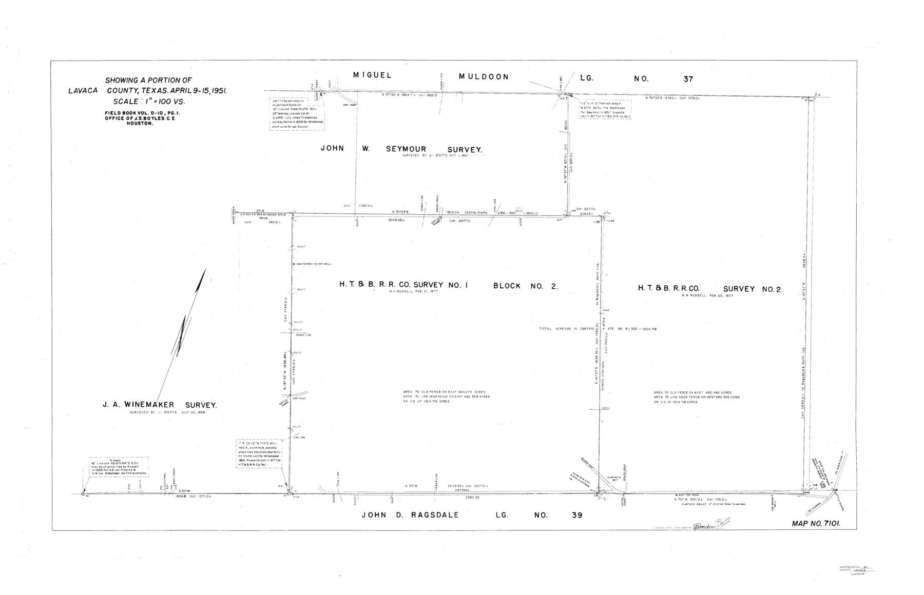
Lavaca County Sketch File 21
Showing a portion of Lavaca County, Texas
-
Map/Doc
10520
-
Collection
General Map Collection
-
Object Dates
4/15/1951 (Creation Date)
8/10/1951 (File Date)
-
People and Organizations
J.S. Boyles (Surveyor/Engineer)
-
Counties
Lavaca
-
Subjects
Surveying Sketch File
-
Height x Width
60.6 x 39.1 inches
153.9 x 99.3 cm
-
Medium
paper, print
-
Scale
1" = 100 varas
Part of: General Map Collection
Flight Mission No. DQN-7K, Frame 5, Calhoun County

Print $20.00
- Digital $50.00
Flight Mission No. DQN-7K, Frame 5, Calhoun County
1953
Size 18.5 x 19.1 inches
Map/Doc 84456
Chambers County Sketch File 1

Print $4.00
- Digital $50.00
Chambers County Sketch File 1
1856
Size 7.8 x 12.2 inches
Map/Doc 17516

Foard County Sketch File 37

Print $4.00
- Digital $50.00
Foard County Sketch File 37
1891
Size 11.2 x 9.1 inches
Map/Doc 22869
Edwards County Sketch File 18

Print $6.00
- Digital $50.00
Edwards County Sketch File 18
Size 16.3 x 10.6 inches
Map/Doc 21738
Uvalde County Working Sketch 32

Print $20.00
- Digital $50.00
Uvalde County Working Sketch 32
1962
Size 27.2 x 41.8 inches
Map/Doc 72102
Descripçion de las Yndias del Norte

Print $20.00
- Digital $50.00
Descripçion de las Yndias del Norte
1601
Size 11.4 x 13.9 inches
Map/Doc 94850
Gregg County Boundary File 1

Print $6.00
- Digital $50.00
Gregg County Boundary File 1
Size 10.0 x 7.9 inches
Map/Doc 53981
Map of Eagle Lake

Print $20.00
- Digital $50.00
Map of Eagle Lake
1938
Size 13.0 x 17.0 inches
Map/Doc 2208
Map of east part of West Bay & SW part of Galveston Bay, Galveston County showing subdivision for mineral development

Print $40.00
- Digital $50.00
Map of east part of West Bay & SW part of Galveston Bay, Galveston County showing subdivision for mineral development
1963
Size 43.0 x 60.8 inches
Map/Doc 2976
Lavaca County Working Sketch 5

Print $20.00
- Digital $50.00
Lavaca County Working Sketch 5
1940
Size 21.3 x 35.2 inches
Map/Doc 70358
Harris County Sketch File 83

Print $20.00
- Digital $50.00
Harris County Sketch File 83
1898
Size 18.5 x 27.3 inches
Map/Doc 11671
You may also like
[Scurry and Zavala County School Lands, and Blocks X, D, K, D-14, D-11, and E]
![91201, [Scurry and Zavala County School Lands, and Blocks X, D, K, D-14, D-11, and E], Twichell Survey Records](https://historictexasmaps.com/wmedia_w700/maps/91201-1.tif.jpg)
Print $20.00
- Digital $50.00
[Scurry and Zavala County School Lands, and Blocks X, D, K, D-14, D-11, and E]
Size 43.7 x 37.2 inches
Map/Doc 91201
Jeff Davis County Working Sketch 19

Print $40.00
- Digital $50.00
Jeff Davis County Working Sketch 19
1957
Size 71.3 x 34.1 inches
Map/Doc 66514
Controlled Mosaic by Jack Amman Photogrammetric Engineers, Inc - Sheet 41

Print $20.00
- Digital $50.00
Controlled Mosaic by Jack Amman Photogrammetric Engineers, Inc - Sheet 41
1954
Size 20.0 x 24.0 inches
Map/Doc 83497
Illinois, Missouri, Iowa, Wisconsin and Minnesota

Print $20.00
- Digital $50.00
Illinois, Missouri, Iowa, Wisconsin and Minnesota
1885
Size 12.2 x 9.0 inches
Map/Doc 93521
Karte des Staates, Texas

Print $20.00
- Digital $50.00
Karte des Staates, Texas
1851
Size 17.8 x 19.9 inches
Map/Doc 97191
Mitchell County Sketch File 13

Print $20.00
- Digital $50.00
Mitchell County Sketch File 13
1925
Size 19.3 x 16.3 inches
Map/Doc 12100
Dickens County Sketch File 17

Print $6.00
- Digital $50.00
Dickens County Sketch File 17
1909
Size 12.2 x 11.8 inches
Map/Doc 20977
The Inca, Machu Picchu Salutes the Sun

The Inca, Machu Picchu Salutes the Sun
Size 20.4 x 31.3 inches
Map/Doc 95935

Aransas County Rolled Sketch 31

Print $20.00
- Digital $50.00
Aransas County Rolled Sketch 31
1986
Size 30.0 x 41.4 inches
Map/Doc 77498
Chambers County Sketch File 28

Print $20.00
- Digital $50.00
Chambers County Sketch File 28
1934
Size 26.0 x 19.2 inches
Map/Doc 11067
Travis County Sketch File 2

Print $4.00
- Digital $50.00
Travis County Sketch File 2
1851
Size 8.2 x 9.9 inches
Map/Doc 38271