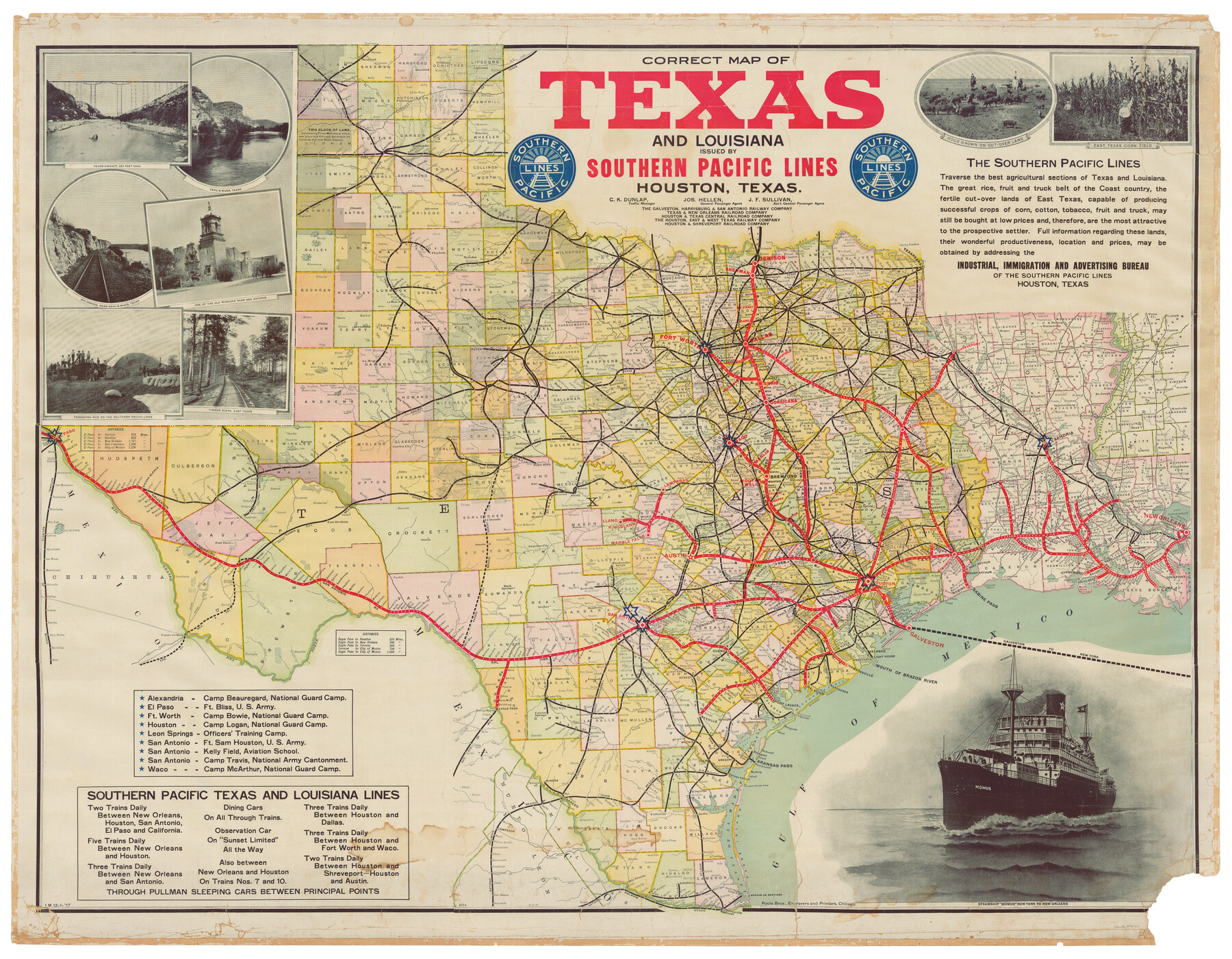
Correct Map of Texas and Louisiana
Z-1-4
-
Map/Doc
2142
-
Collection
General Map Collection
-
Object Dates
12/1/1917 (Creation Date)
-
People and Organizations
Southern Pacific Lines (Publisher)
Poole Bros, Engravers and Printers, Chicago (Printer)
-
Subjects
Old Southwest State of Texas
-
Height x Width
41.6 x 53.6 inches
105.7 x 136.1 cm
-
Comments
Partially adopted by Linda Abbett and Friends of the Texas General Land Office.
Conservation funded in 2005. -
URLs
https://medium.com/save-texas-history/correct-map-of-texas-and-louisiana-f51db41100b2
Part of: General Map Collection
Red River County Working Sketch 7

Print $20.00
- Digital $50.00
Red River County Working Sketch 7
1919
Size 25.0 x 24.1 inches
Map/Doc 71990
Hudspeth County Rolled Sketch 71

Print $40.00
- Digital $50.00
Hudspeth County Rolled Sketch 71
1992
Size 38.2 x 48.6 inches
Map/Doc 9234
[Sketch for Mineral Application 16777]
![65653, [Sketch for Mineral Application 16777], General Map Collection](https://historictexasmaps.com/wmedia_w700/maps/65653-1.tif.jpg)
Print $40.00
- Digital $50.00
[Sketch for Mineral Application 16777]
Size 19.5 x 79.9 inches
Map/Doc 65653
Cherokee County Working Sketch 21

Print $40.00
- Digital $50.00
Cherokee County Working Sketch 21
1969
Size 37.6 x 57.0 inches
Map/Doc 67976

Galveston County NRC Article 33.136 Sketch 15

Print $24.00
- Digital $50.00
Galveston County NRC Article 33.136 Sketch 15
2002
Size 23.0 x 35.0 inches
Map/Doc 77046
A New Map of the Whole Continent of America. Divided into North and South and West Indies, wherein are exactly decribed the United States of North America as well as the Several European Possessions according to the Preliminaries of Peace…

Print $40.00
- Digital $50.00
A New Map of the Whole Continent of America. Divided into North and South and West Indies, wherein are exactly decribed the United States of North America as well as the Several European Possessions according to the Preliminaries of Peace…
Size 22.0 x 48.7 inches
Map/Doc 95136
Jefferson County Rolled Sketch 31

Print $425.00
- Digital $50.00
Jefferson County Rolled Sketch 31
1955
Size 10.1 x 15.3 inches
Map/Doc 46323

Texas Panhandle East Boundary Line

Print $20.00
- Digital $50.00
Texas Panhandle East Boundary Line
1898
Size 11.6 x 35.5 inches
Map/Doc 1741
Duval County Sketch File 34a

Print $20.00
- Digital $50.00
Duval County Sketch File 34a
1935
Size 45.7 x 34.2 inches
Map/Doc 10369
Pecos County Rolled Sketch 139

Print $40.00
- Digital $50.00
Pecos County Rolled Sketch 139
1953
Size 41.0 x 57.4 inches
Map/Doc 9732
You may also like
[Texas & Pacific Railway, Longview to Dallas]
![64098, [Texas & Pacific Railway, Longview to Dallas], General Map Collection](https://historictexasmaps.com/wmedia_w700/maps/64098.tif.jpg)
Print $40.00
- Digital $50.00
[Texas & Pacific Railway, Longview to Dallas]
1873
Size 14.5 x 121.6 inches
Map/Doc 64098
Flight Mission No. BRE-2P, Frame 134, Nueces County

Print $20.00
- Digital $50.00
Flight Mission No. BRE-2P, Frame 134, Nueces County
1956
Size 18.4 x 22.3 inches
Map/Doc 86807
Palo Pinto County Sketch File 20

Print $6.00
- Digital $50.00
Palo Pinto County Sketch File 20
1891
Size 12.5 x 10.9 inches
Map/Doc 33402
Jeff Davis County Rolled Sketch 44

Print $20.00
- Digital $50.00
Jeff Davis County Rolled Sketch 44
2014
Size 19.8 x 34.7 inches
Map/Doc 94243

Index to Titles, Field Notes, and Plats in the Spanish Archives

Index to Titles, Field Notes, and Plats in the Spanish Archives
1942
Size 17.5 x 10.1 inches
Map/Doc 94524
Hartley County Working Sketch 4

Print $20.00
- Digital $50.00
Hartley County Working Sketch 4
1934
Size 23.9 x 30.6 inches
Map/Doc 66054
Texas, Mexico and part of the United States compiled from the latest and best authorities

Print $20.00
- Digital $50.00
Texas, Mexico and part of the United States compiled from the latest and best authorities
1836
Size 9.1 x 11.0 inches
Map/Doc 95958
Flight Mission No. BQR-22K, Frame 41, Brazoria County

Print $20.00
- Digital $50.00
Flight Mission No. BQR-22K, Frame 41, Brazoria County
1953
Size 18.8 x 22.5 inches
Map/Doc 84125
Mirando City, Webb County, Texas

Print $40.00
- Digital $50.00
Mirando City, Webb County, Texas
1937
Size 60.0 x 36.2 inches
Map/Doc 10132

Brazoria County NRC Article 33.136 Sketch 18

Print $24.00
- Digital $50.00
Brazoria County NRC Article 33.136 Sketch 18
2015
Size 24.0 x 36.0 inches
Map/Doc 95066