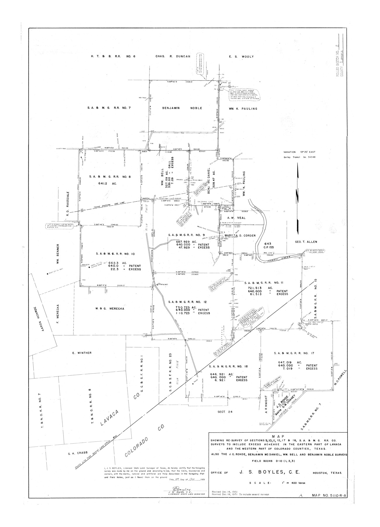
Lavaca County Rolled Sketch 2
Map showing re-survey of sections 9, 10, 11, 12, 17, & 18, S. A. & M. G. R.R. Co. surveys to include excess acreage in the eastern part of Lavaca and the western part of Colorado Counties, Texas
-
Map/Doc
6592
-
Collection
General Map Collection
-
Object Dates
1951/12/14 (Revision Date)
1952/4/2 (File Date)
1951/10/10 (Creation Date)
1951/12/18 (Revision Date)
-
People and Organizations
J.S. Boyles (Surveyor/Engineer)
-
Counties
Lavaca Colorado
-
Subjects
Surveying Rolled Sketch
-
Height x Width
37.0 x 26.7 inches
94.0 x 67.8 cm
-
Scale
1" = 400 varas
Part of: General Map Collection
Phelps & Watson's historical and military map of the border & southern states

Print $20.00
- Digital $50.00
Phelps & Watson's historical and military map of the border & southern states
1863
Size 26.1 x 37.1 inches
Map/Doc 97083
Shelby County Working Sketch 23b

Print $20.00
- Digital $50.00
Shelby County Working Sketch 23b
1983
Size 36.6 x 24.7 inches
Map/Doc 63877
Presidio County Sketch File 28A

Print $20.00
- Digital $50.00
Presidio County Sketch File 28A
1890
Size 16.3 x 17.9 inches
Map/Doc 11710
Hutchinson County Sketch File 19

Print $16.00
- Digital $50.00
Hutchinson County Sketch File 19
1913
Size 8.0 x 5.2 inches
Map/Doc 27234
Stephens County

Print $20.00
- Digital $50.00
Stephens County
1940
Size 42.9 x 41.0 inches
Map/Doc 63045
Map of Coleman County

Print $20.00
- Digital $50.00
Map of Coleman County
Size 26.8 x 19.8 inches
Map/Doc 3408
Flight Mission No. DAG-21K, Frame 100, Matagorda County

Print $20.00
- Digital $50.00
Flight Mission No. DAG-21K, Frame 100, Matagorda County
1952
Size 18.6 x 22.3 inches
Map/Doc 86429
Ward County Working Sketch 35

Print $20.00
- Digital $50.00
Ward County Working Sketch 35
1968
Size 46.4 x 43.0 inches
Map/Doc 72341
Archer County Working Sketch 17

Print $3.00
- Digital $50.00
Archer County Working Sketch 17
1951
Size 10.7 x 12.2 inches
Map/Doc 67158
Schleicher County Rolled Sketch 24

Print $20.00
- Digital $50.00
Schleicher County Rolled Sketch 24
Size 29.1 x 15.9 inches
Map/Doc 7763
Upshur County Sketch File 2a

Print $4.00
- Digital $50.00
Upshur County Sketch File 2a
Size 12.9 x 8.2 inches
Map/Doc 38734
Baylor County Sketch File 27

Print $4.00
- Digital $50.00
Baylor County Sketch File 27
1895
Size 11.1 x 8.9 inches
Map/Doc 14226
You may also like
Pecos County Rolled Sketch 183

Print $20.00
- Digital $50.00
Pecos County Rolled Sketch 183
1982
Size 39.6 x 27.5 inches
Map/Doc 7302

McMullen County Working Sketch 36

Print $20.00
- Digital $50.00
McMullen County Working Sketch 36
1963
Size 40.1 x 41.5 inches
Map/Doc 70737
[Section 34, Block 194 G. C. & S. F.]
![91671, [Section 34, Block 194 G. C. & S. F.], Twichell Survey Records](https://historictexasmaps.com/wmedia_w700/maps/91671-1.tif.jpg)
Print $2.00
- Digital $50.00
[Section 34, Block 194 G. C. & S. F.]
1927
Size 7.6 x 5.9 inches
Map/Doc 91671
Index to Field Notes, Plats: Spanish Archives

Index to Field Notes, Plats: Spanish Archives
1981
Map/Doc 94531
Kimble County Sketch File 36

Print $20.00
- Digital $50.00
Kimble County Sketch File 36
1963
Size 22.2 x 25.0 inches
Map/Doc 11932
Dallam County Sketch File 6

Print $60.00
- Digital $50.00
Dallam County Sketch File 6
Size 12.4 x 17.0 inches
Map/Doc 20350
Hill County Sketch File 6

Print $4.00
- Digital $50.00
Hill County Sketch File 6
1848
Size 13.9 x 8.7 inches
Map/Doc 26470
Flight Mission No. BQR-3K, Frame 159, Brazoria County

Print $20.00
- Digital $50.00
Flight Mission No. BQR-3K, Frame 159, Brazoria County
1952
Size 18.6 x 22.3 inches
Map/Doc 83986
Coke County Rolled Sketch 11

Print $20.00
- Digital $50.00
Coke County Rolled Sketch 11
1949
Size 32.6 x 26.3 inches
Map/Doc 5512
Brewster County Rolled Sketch 106

Print $20.00
- Digital $50.00
Brewster County Rolled Sketch 106
1958
Size 20.7 x 24.6 inches
Map/Doc 5258
