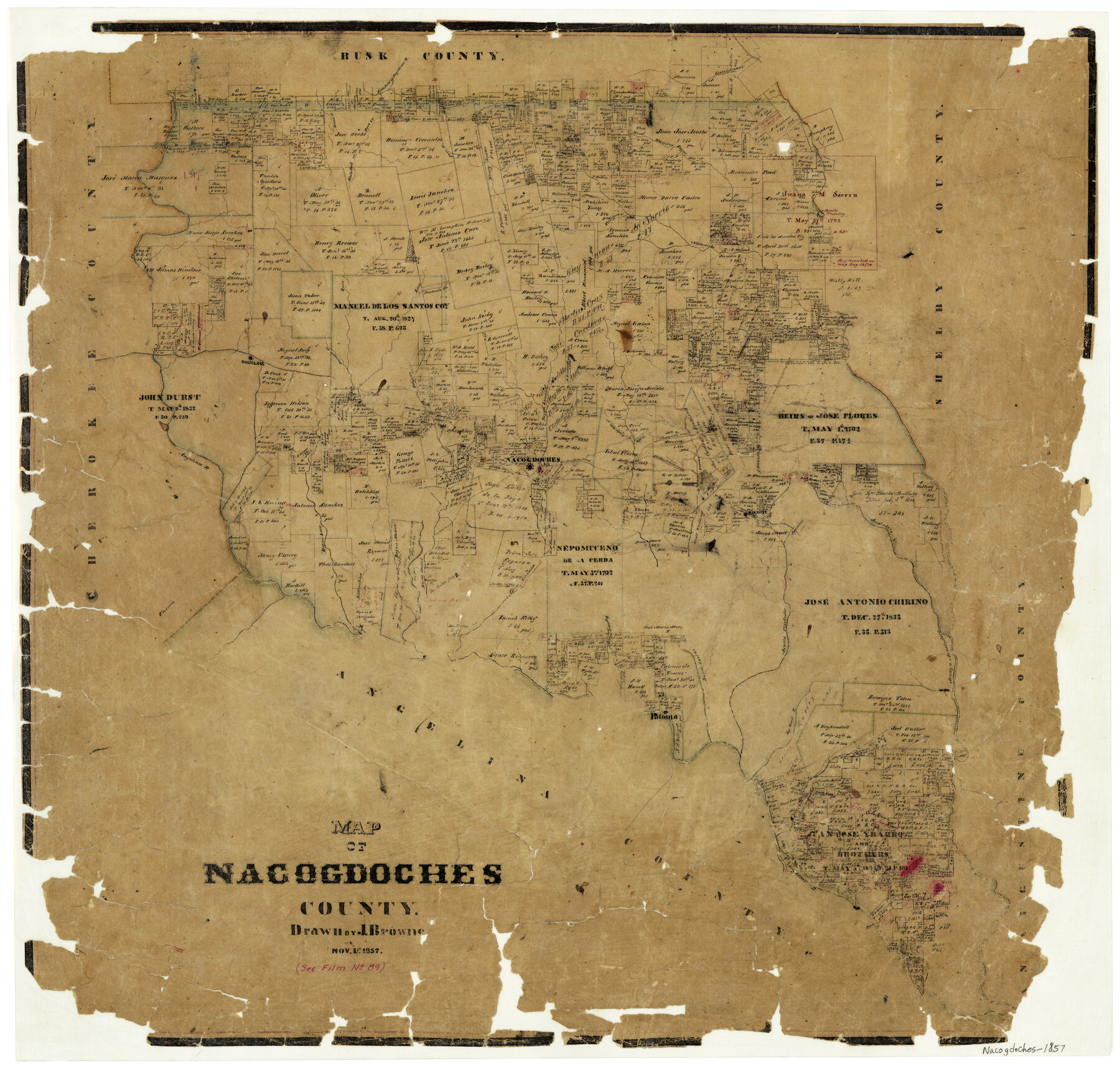
Map of Nacogdoches County
-
Map/Doc
3907
-
Collection
General Map Collection
-
Object Dates
11/1/1857 (Creation Date)
-
People and Organizations
Texas General Land Office (Publisher)
J. Browne (Draftsman)
-
Counties
Nacogdoches
-
Subjects
County
-
Height x Width
22.9 x 24.3 inches
58.2 x 61.7 cm
-
Features
Patonia
Amaladero Creek
Agallitas Creek
Aluzun Bayou
Little Loco [Bayou]
Loco Bayou
Dorr Creek
Arolla Visitador
La Vaca Creek
Arroyo Arnoladero
Carizo Bayou
Melrose
Nadunto Creek
Red Creek
Botija Creek
Morrel Bayou
Nacogdoches
Beech Creek
Aycitos Crossing
Raiz Creek
East Fork of Angelina River
Wandes Bayou
Golondrino Creek
Tellisfore Creek
White Oak Creek
Dills Creek
Naconichi Creek
Gualajote Creek
Loco Creek
Pen Creek
Nacosote Creek
Douglass
Angelina River
Moral Bayou
Aycitos Bayou
Old San Antonio Road
La Nana Bayou
Shelbyville Road
Part of: General Map Collection
Galveston County Working Sketch 22

Print $20.00
- Digital $50.00
Galveston County Working Sketch 22
1988
Size 27.4 x 38.3 inches
Map/Doc 69359
Map of Wichita County

Print $20.00
- Digital $50.00
Map of Wichita County
1874
Size 22.8 x 21.0 inches
Map/Doc 4142
Tyler County Working Sketch 18

Print $20.00
- Digital $50.00
Tyler County Working Sketch 18
1965
Size 31.4 x 27.3 inches
Map/Doc 69488
Galveston County Rolled Sketch 46

Print $40.00
- Digital $50.00
Galveston County Rolled Sketch 46
2000
Size 32.0 x 48.3 inches
Map/Doc 5981

Harrison County Sketch File 22

Print $20.00
- Digital $50.00
Harrison County Sketch File 22
1917
Size 24.6 x 23.4 inches
Map/Doc 11695
Kendall County Sketch File 4

Print $4.00
- Digital $50.00
Kendall County Sketch File 4
Size 7.8 x 8.6 inches
Map/Doc 28684
Kimble County Working Sketch 4

Print $20.00
- Digital $50.00
Kimble County Working Sketch 4
1913
Size 26.8 x 21.7 inches
Map/Doc 70072
Cochran County Sketch File 2

Print $22.00
- Digital $50.00
Cochran County Sketch File 2
1907
Size 4.4 x 13.6 inches
Map/Doc 18539
Terry County Working Sketch 1

Print $20.00
- Digital $50.00
Terry County Working Sketch 1
1938
Size 24.0 x 19.9 inches
Map/Doc 62106
Harris County Rolled Sketch 65

Print $40.00
- Digital $50.00
Harris County Rolled Sketch 65
1922
Size 41.6 x 68.5 inches
Map/Doc 9128
Lamar County State Real Property Sketch 1

Print $20.00
- Digital $50.00
Lamar County State Real Property Sketch 1
2013
Size 24.0 x 36.0 inches
Map/Doc 93660
You may also like
Wood County Boundary File 7

Print $34.00
- Digital $50.00
Wood County Boundary File 7
Size 13.3 x 8.8 inches
Map/Doc 60187
J. De Cordova's Map of the State of Texas Compiled from the records of the General Land Office of the State

Print $20.00
J. De Cordova's Map of the State of Texas Compiled from the records of the General Land Office of the State
1851
Size 35.1 x 33.0 inches
Map/Doc 76223
[Map of Navarro County]
![81900, [Map of Navarro County], General Map Collection](https://historictexasmaps.com/wmedia_w700/maps/81900.tif.jpg)
Print $20.00
- Digital $50.00
[Map of Navarro County]
1858
Size 18.0 x 23.5 inches
Map/Doc 81900
Martin County Sketch File 9

Print $20.00
Martin County Sketch File 9
Size 19.7 x 27.4 inches
Map/Doc 12029
Young County Working Sketch 24

Print $20.00
- Digital $50.00
Young County Working Sketch 24
1977
Size 25.7 x 16.3 inches
Map/Doc 62047
Duval County Working Sketch 15

Print $20.00
- Digital $50.00
Duval County Working Sketch 15
1938
Size 23.3 x 22.7 inches
Map/Doc 68728
Lee County Working Sketch 10

Print $20.00
- Digital $50.00
Lee County Working Sketch 10
1979
Size 32.6 x 35.4 inches
Map/Doc 70389
[Galveston, Harrisburg & San Antonio from El Paso-Presidio county boundary to Presidio-Pecos county boundary]
![64718, [Galveston, Harrisburg & San Antonio from El Paso-Presidio county boundary to Presidio-Pecos county boundary], General Map Collection](https://historictexasmaps.com/wmedia_w700/maps/64718.tif.jpg)
Print $40.00
- Digital $50.00
[Galveston, Harrisburg & San Antonio from El Paso-Presidio county boundary to Presidio-Pecos county boundary]
Size 106.1 x 44.3 inches
Map/Doc 64718
Montague County Working Sketch 32

Print $20.00
- Digital $50.00
Montague County Working Sketch 32
1975
Size 26.0 x 26.1 inches
Map/Doc 71098
Polk County Sketch File 29 1/2

Print $4.00
- Digital $50.00
Polk County Sketch File 29 1/2
Size 8.7 x 12.5 inches
Map/Doc 34204
[Sketch Showing Loma Blanca and San Antonio de Encinal Leagues, Brooks County, Texas]
![4448, [Sketch Showing Loma Blanca and San Antonio de Encinal Leagues, Brooks County, Texas], Maddox Collection](https://historictexasmaps.com/wmedia_w700/maps/4448-1.tif.jpg)
Print $3.00
- Digital $50.00
[Sketch Showing Loma Blanca and San Antonio de Encinal Leagues, Brooks County, Texas]
1912
Size 15.1 x 11.4 inches
Map/Doc 4448
Flight Mission No. CUG-3P, Frame 131, Kleberg County

Print $20.00
- Digital $50.00
Flight Mission No. CUG-3P, Frame 131, Kleberg County
1956
Size 18.7 x 22.4 inches
Map/Doc 86266