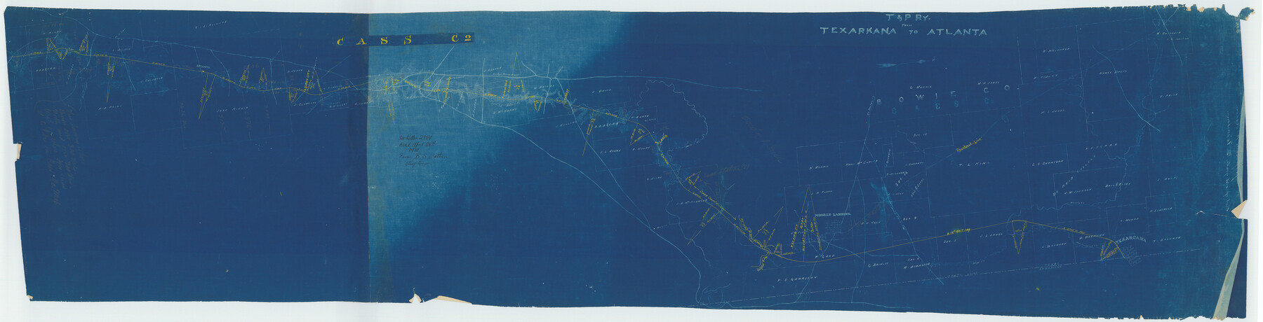
T&P Ry. from Texarkana to Atlanta
Z-2-51, K.7.77
-
Map/Doc
2327
-
Collection
General Map Collection
-
Object Dates
1910 (Creation Date)
1910/4/28 (File Date)
-
People and Organizations
B.S. Wathen (Surveyor/Engineer)
-
Counties
Bowie Cass
-
Subjects
Railroads Texas and Pacific Railroad
-
Height x Width
19.8 x 77.4 inches
50.3 x 196.6 cm
-
Comments
Also shows an abandoned rail line.
-
Features
Days Creek
Road to Boston
Bays Creek Road
Kirbys Ferry Road
Black Bayou
Winborn
Bakers Creek
Rodgers
Sulphur River
Hurricane Creek
T&P
Wards Creek
Alamo
Forest
Springdale
Lanark
Atlanta
Queen City
Moores Landing
Texarcana
Part of: General Map Collection
University Land, Lamar County

Print $20.00
- Digital $50.00
University Land, Lamar County
1906
Size 23.8 x 29.9 inches
Map/Doc 2431
Map of Hall County

Print $20.00
- Digital $50.00
Map of Hall County
1895
Size 25.2 x 20.2 inches
Map/Doc 3619

Nacogdoches County Sketch File 1

Print $4.00
- Digital $50.00
Nacogdoches County Sketch File 1
Size 10.2 x 7.8 inches
Map/Doc 32233
Hays County Sketch File 16a

Print $4.00
- Digital $50.00
Hays County Sketch File 16a
1871
Size 8.2 x 9.7 inches
Map/Doc 26229
Colorado River, Lane City Sheet

Print $4.00
- Digital $50.00
Colorado River, Lane City Sheet
1941
Size 27.0 x 29.9 inches
Map/Doc 65316
Gillespie County

Print $20.00
- Digital $50.00
Gillespie County
1945
Size 36.7 x 45.6 inches
Map/Doc 77289

Harris County Aerial Photograph Index Sheet 8

Print $20.00
- Digital $50.00
Harris County Aerial Photograph Index Sheet 8
1953
Size 22.2 x 16.8 inches
Map/Doc 83702
Jefferson County NRC Article 33.136 Sketch 8

Print $20.00
- Digital $50.00
Jefferson County NRC Article 33.136 Sketch 8
2007
Size 20.1 x 18.7 inches
Map/Doc 87503
Rains County Working Sketch 7

Print $20.00
- Digital $50.00
Rains County Working Sketch 7
1964
Size 32.6 x 38.6 inches
Map/Doc 71833
Wise County Working Sketch 22

Print $20.00
- Digital $50.00
Wise County Working Sketch 22
1980
Size 28.1 x 27.8 inches
Map/Doc 72636
You may also like
Jackson County Rolled Sketch 2

Print $20.00
- Digital $50.00
Jackson County Rolled Sketch 2
Size 14.1 x 17.9 inches
Map/Doc 6335
[John H. Tyler and Bob Reid Strip Surveys in Yates Field]
![91582, [John H. Tyler and Bob Reid Strip Surveys in Yates Field], Twichell Survey Records](https://historictexasmaps.com/wmedia_w700/maps/91582-1.tif.jpg)
Print $2.00
- Digital $50.00
[John H. Tyler and Bob Reid Strip Surveys in Yates Field]
Size 14.3 x 8.8 inches
Map/Doc 91582
Hutchinson County Sketch File 51

Print $18.00
- Digital $50.00
Hutchinson County Sketch File 51
1993
Size 14.2 x 8.6 inches
Map/Doc 27440
Stephens County Sketch File 8

Print $40.00
- Digital $50.00
Stephens County Sketch File 8
1879
Size 13.5 x 14.2 inches
Map/Doc 37027
Howard County

Print $20.00
- Digital $50.00
Howard County
1922
Size 42.3 x 36.2 inches
Map/Doc 95535
[Surveys along North and South Branches of Plum Creek, and vicinity]
![91405, [Surveys along North and South Branches of Plum Creek, and vicinity], Twichell Survey Records](https://historictexasmaps.com/wmedia_w700/maps/91405-1.tif.jpg)
Print $2.00
- Digital $50.00
[Surveys along North and South Branches of Plum Creek, and vicinity]
Size 11.0 x 8.6 inches
Map/Doc 91405
Rockwall County

Print $20.00
- Digital $50.00
Rockwall County
1941
Size 26.0 x 21.3 inches
Map/Doc 77410
Geological map of Texas showing approximate locations and drilling wells. Also names of companies drilling

Print $20.00
- Digital $50.00
Geological map of Texas showing approximate locations and drilling wells. Also names of companies drilling
1920
Size 26.9 x 26.6 inches
Map/Doc 93937
[Blocks 10T, O7, S2, S3, T2, T3, JB and A]
![89953, [Blocks 10T, O7, S2, S3, T2, T3, JB and A], Twichell Survey Records](https://historictexasmaps.com/wmedia_w700/maps/89953-1.tif.jpg)
Print $20.00
- Digital $50.00
[Blocks 10T, O7, S2, S3, T2, T3, JB and A]
Size 41.8 x 37.7 inches
Map/Doc 89953
County Map of the Pan-Handle of Texas, and the line of the Denver, Texas and Ft. Worth R'y

Print $20.00
County Map of the Pan-Handle of Texas, and the line of the Denver, Texas and Ft. Worth R'y
1888
Size 7.5 x 10.9 inches
Map/Doc 76296
Shelby County Working Sketch 6

Print $20.00
- Digital $50.00
Shelby County Working Sketch 6
1941
Size 25.1 x 18.9 inches
Map/Doc 63859
Old Miscellaneous File 9

Print $4.00
- Digital $50.00
Old Miscellaneous File 9
1871
Size 9.8 x 8.0 inches
Map/Doc 75433