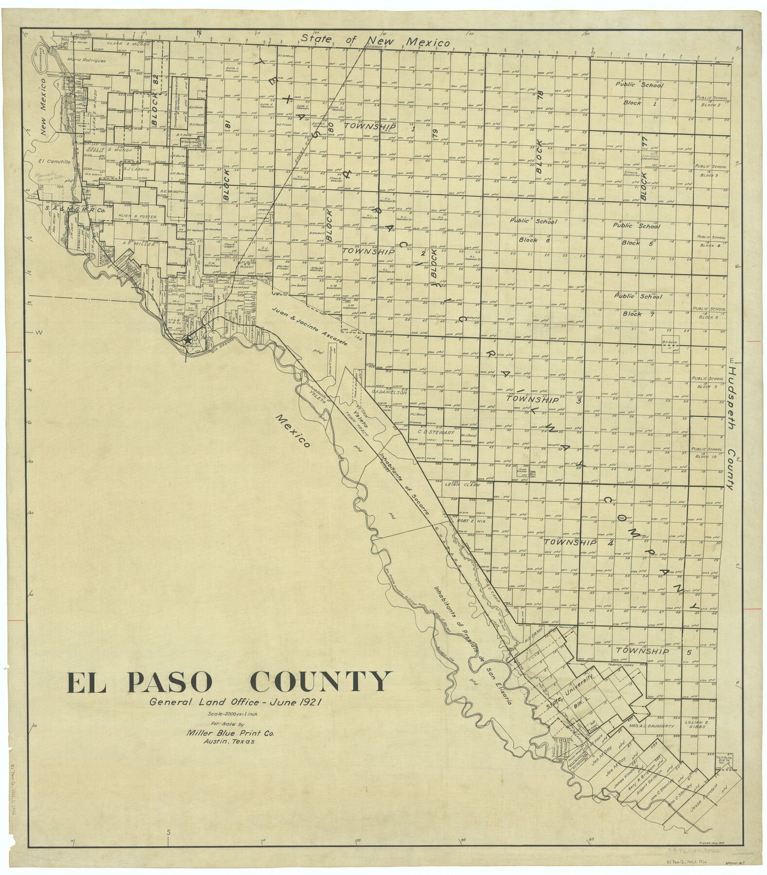
El Paso Co.
-
Map/Doc
66818
-
Collection
General Map Collection
-
Object Dates
1921 (Creation Date)
-
People and Organizations
Texas General Land Office (Publisher)
-
Counties
El Paso
-
Subjects
County
-
Height x Width
46.8 x 41.0 inches
118.9 x 104.1 cm
-
Comments
Traced in August 1926.
Part of: General Map Collection
Hartley County Working Sketch 8

Print $20.00
- Digital $50.00
Hartley County Working Sketch 8
1982
Size 34.0 x 32.6 inches
Map/Doc 66058
Angelina County Working Sketch 3

Print $20.00
- Digital $50.00
Angelina County Working Sketch 3
1894
Size 17.9 x 16.6 inches
Map/Doc 67083
Parker County Working Sketch 19-2

Print $20.00
- Digital $50.00
Parker County Working Sketch 19-2
2005
Map/Doc 83580
Map of Uvalde County

Print $20.00
- Digital $50.00
Map of Uvalde County
1862
Size 27.4 x 20.7 inches
Map/Doc 4109
Galveston County Sketch File 41

Print $7.00
- Digital $50.00
Galveston County Sketch File 41
Size 11.3 x 8.9 inches
Map/Doc 23451
Capitol Grounds, Austin

Print $20.00
- Digital $50.00
Capitol Grounds, Austin
Size 35.4 x 40.5 inches
Map/Doc 16955
Travis County Sketch File 67

Print $10.00
- Digital $50.00
Travis County Sketch File 67
1951
Size 14.3 x 9.0 inches
Map/Doc 38446
Childress County Sketch File 24

Print $4.00
- Digital $50.00
Childress County Sketch File 24
1917
Size 12.9 x 8.6 inches
Map/Doc 18384
Pecos County Sketch File 41

Print $32.00
- Digital $50.00
Pecos County Sketch File 41
1919
Size 11.2 x 8.8 inches
Map/Doc 33729
Real County Working Sketch 68

Print $20.00
- Digital $50.00
Real County Working Sketch 68
1973
Size 21.9 x 24.4 inches
Map/Doc 71960
Flight Mission No. BQR-5K, Frame 64, Brazoria County

Print $20.00
- Digital $50.00
Flight Mission No. BQR-5K, Frame 64, Brazoria County
1952
Size 18.8 x 22.5 inches
Map/Doc 84009
Flight Mission No. BRE-1P, Frame 141, Nueces County

Print $20.00
- Digital $50.00
Flight Mission No. BRE-1P, Frame 141, Nueces County
1956
Size 18.7 x 22.5 inches
Map/Doc 86701
You may also like
Hamilton County Map

Print $40.00
- Digital $50.00
Hamilton County Map
1887
Size 38.2 x 54.4 inches
Map/Doc 16844
Flight Mission No. DAG-24K, Frame 156, Matagorda County

Print $20.00
- Digital $50.00
Flight Mission No. DAG-24K, Frame 156, Matagorda County
1953
Size 18.4 x 22.3 inches
Map/Doc 86570
Harris County NRC Article 33.136 Sketch 2

Print $30.00
- Digital $50.00
Harris County NRC Article 33.136 Sketch 2
2000
Size 30.6 x 42.2 inches
Map/Doc 61596
Kerr County Working Sketch 11

Print $20.00
- Digital $50.00
Kerr County Working Sketch 11
1951
Size 30.3 x 29.9 inches
Map/Doc 70042
Terre Nove (verso)

Print $20.00
- Digital $50.00
Terre Nove (verso)
1522
Size 12.2 x 7.8 inches
Map/Doc 93802
Pecos County Rolled Sketch 50

Print $20.00
- Digital $50.00
Pecos County Rolled Sketch 50
1913
Size 23.5 x 13.0 inches
Map/Doc 7226
Bell County Working Sketch 4

Print $20.00
- Digital $50.00
Bell County Working Sketch 4
1942
Size 26.9 x 21.0 inches
Map/Doc 67344
Winkler County Rolled Sketch 7

Print $20.00
- Digital $50.00
Winkler County Rolled Sketch 7
1929
Size 27.6 x 32.5 inches
Map/Doc 8273
Crockett County Working Sketch 5

Print $40.00
- Digital $50.00
Crockett County Working Sketch 5
Size 12.3 x 62.5 inches
Map/Doc 68338
Nacogdoches County Working Sketch 10

Print $20.00
- Digital $50.00
Nacogdoches County Working Sketch 10
1981
Size 19.0 x 17.6 inches
Map/Doc 71226
J. De Cordova's Map of the State of Texas Compiled from the records of the General Land Office of the State

Print $20.00
- Digital $50.00
J. De Cordova's Map of the State of Texas Compiled from the records of the General Land Office of the State
1867
Size 38.0 x 35.4 inches
Map/Doc 93759
United States - Gulf Coast - Padre I. and Laguna Madre Lat. 27° 12' to Lat. 26° 33' Texas

Print $20.00
- Digital $50.00
United States - Gulf Coast - Padre I. and Laguna Madre Lat. 27° 12' to Lat. 26° 33' Texas
1913
Size 26.9 x 18.2 inches
Map/Doc 72820