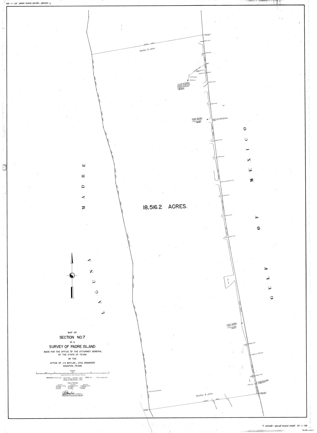
Map of section no. 7 of a survey of Padre Island made for the Office of the Attorney General of the State of Texas
-
Map/Doc
2263
-
Collection
General Map Collection
-
Object Dates
1941/9/9 (Creation Date)
-
People and Organizations
J.S. Boyles (Surveyor/Engineer)
-
Counties
Kenedy
-
Height x Width
56.3 x 41.2 inches
143.0 x 104.6 cm
-
Medium
mylar, print
-
Comments
Map 7 of 12. See map numbers 2257 through 2268 (inclusive) for complete set of maps. See 2271 for transcription of field notes.
Related maps
Map of survey of a part of Padre and Mustang Islands made for the Office of the Attorney General of the State of Texas

Print $20.00
- Digital $50.00
Map of survey of a part of Padre and Mustang Islands made for the Office of the Attorney General of the State of Texas
1941
Size 40.8 x 39.5 inches
Map/Doc 2257
Map of sections 1 & 2 of a survey of Padre Island made for the Office of the Attorney General of the State of Texas

Print $20.00
- Digital $50.00
Map of sections 1 & 2 of a survey of Padre Island made for the Office of the Attorney General of the State of Texas
1941
Size 40.8 x 39.8 inches
Map/Doc 2258
Map of section no. 3 of a survey of Padre Island made for the Office of the Attorney General of the State of Texas

Print $40.00
- Digital $50.00
Map of section no. 3 of a survey of Padre Island made for the Office of the Attorney General of the State of Texas
1941
Size 49.6 x 40.2 inches
Map/Doc 2259
Map of section no. 4 of a survey of Padre Island made for the Office of the Attorney General of the State of Texas

Print $40.00
- Digital $50.00
Map of section no. 4 of a survey of Padre Island made for the Office of the Attorney General of the State of Texas
1941
Size 82.6 x 40.8 inches
Map/Doc 2260
Map of section no. 5 of a survey of Padre Island made for the Office of the Attorney General of the State of Texas

Print $40.00
- Digital $50.00
Map of section no. 5 of a survey of Padre Island made for the Office of the Attorney General of the State of Texas
1941
Size 49.8 x 40.0 inches
Map/Doc 2261
Map of section no. 6 of a survey of Padre Island made for the Office of the Attorney General of the State of Texas

Print $40.00
- Digital $50.00
Map of section no. 6 of a survey of Padre Island made for the Office of the Attorney General of the State of Texas
1941
Size 57.9 x 40.8 inches
Map/Doc 2262
Map of section no. 8 of a survey of Padre Island made for the Office of the Attorney General of the State of Texas

Print $40.00
- Digital $50.00
Map of section no. 8 of a survey of Padre Island made for the Office of the Attorney General of the State of Texas
1941
Size 56.2 x 40.3 inches
Map/Doc 2264
Map of section no. 9 of a survey of Padre Island made for the Office of the Attorney General of the State of Texas

Print $40.00
- Digital $50.00
Map of section no. 9 of a survey of Padre Island made for the Office of the Attorney General of the State of Texas
1941
Size 58.3 x 42.5 inches
Map/Doc 2265
Map of section no. 10 of a survey of Padre Island made for the Office of the Attorney General of the State of Texas

Print $40.00
- Digital $50.00
Map of section no. 10 of a survey of Padre Island made for the Office of the Attorney General of the State of Texas
1941
Size 57.2 x 40.6 inches
Map/Doc 2266
Map of section no. 11 of a survey of Padre Island made for the Office of the Attorney General of the State of Texas

Print $40.00
- Digital $50.00
Map of section no. 11 of a survey of Padre Island made for the Office of the Attorney General of the State of Texas
1941
Size 60.1 x 40.4 inches
Map/Doc 2267
Map of section no. 12 of a survey of Padre Island made for the Office of the Attorney General of the State of Texas

Print $40.00
- Digital $50.00
Map of section no. 12 of a survey of Padre Island made for the Office of the Attorney General of the State of Texas
1941
Size 75.9 x 41.0 inches
Map/Doc 2268
Field Notes of a Survey of Padre Island

Print $20.00
- Digital $50.00
Field Notes of a Survey of Padre Island
1941
Size 43.2 x 30.0 inches
Map/Doc 2271
Part of: General Map Collection
Comanche County Working Sketch 13

Print $20.00
- Digital $50.00
Comanche County Working Sketch 13
1957
Size 18.4 x 15.0 inches
Map/Doc 68147
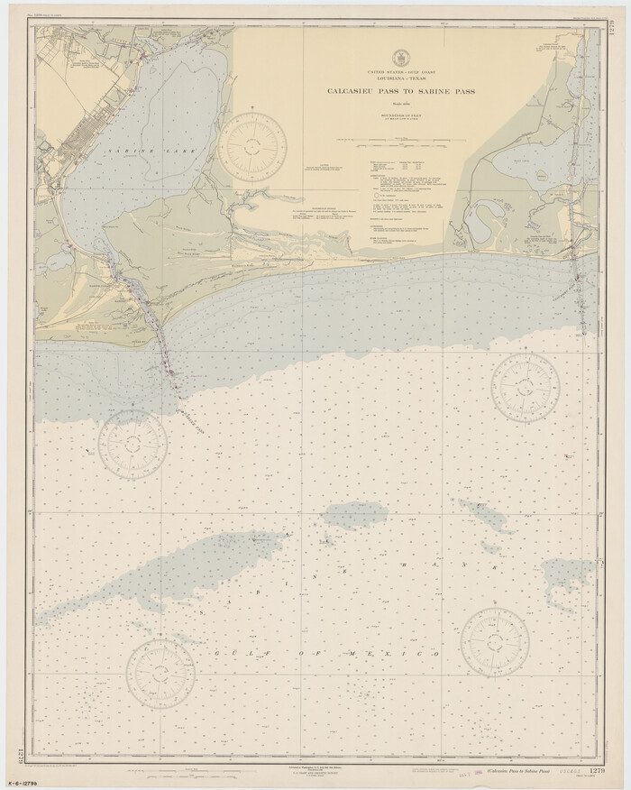
Calcasieu Pass to Sabine Pass
Print $20.00
- Digital $50.00
Calcasieu Pass to Sabine Pass
1946
Size 44.7 x 35.7 inches
Map/Doc 69806
Navigation Maps of Gulf Intracoastal Waterway, Port Arthur to Brownsville, Texas

Print $4.00
- Digital $50.00
Navigation Maps of Gulf Intracoastal Waterway, Port Arthur to Brownsville, Texas
1951
Size 16.7 x 21.5 inches
Map/Doc 65443
Ochiltree County

Print $20.00
- Digital $50.00
Ochiltree County
1958
Size 41.0 x 33.1 inches
Map/Doc 77386
Houston County Working Sketch 14

Print $20.00
- Digital $50.00
Houston County Working Sketch 14
1957
Size 35.1 x 24.0 inches
Map/Doc 66244
Wise County Sketch File 27

Print $4.00
- Digital $50.00
Wise County Sketch File 27
1857
Size 12.4 x 8.2 inches
Map/Doc 40576
Bee County Boundary File 4

Print $22.00
- Digital $50.00
Bee County Boundary File 4
Size 12.9 x 8.1 inches
Map/Doc 50441
United States - Gulf Coast - Galveston to Rio Grande

Print $20.00
- Digital $50.00
United States - Gulf Coast - Galveston to Rio Grande
1940
Size 27.4 x 18.3 inches
Map/Doc 72757
Jefferson County Rolled Sketch 6

Print $20.00
- Digital $50.00
Jefferson County Rolled Sketch 6
1916
Size 34.2 x 36.7 inches
Map/Doc 9271

Coke County Rolled Sketch 33

Print $20.00
- Digital $50.00
Coke County Rolled Sketch 33
2004
Size 28.9 x 40.5 inches
Map/Doc 82987
Freestone County Working Sketch 17

Print $20.00
- Digital $50.00
Freestone County Working Sketch 17
1980
Size 44.8 x 31.0 inches
Map/Doc 69259
You may also like
Hutchinson County Rolled Sketch 44-16

Print $20.00
- Digital $50.00
Hutchinson County Rolled Sketch 44-16
2002
Size 24.0 x 36.0 inches
Map/Doc 77552
Trace of a copy of the map captured at the battle of Resaca de la Palma

Print $20.00
- Digital $50.00
Trace of a copy of the map captured at the battle of Resaca de la Palma
Size 18.3 x 27.3 inches
Map/Doc 73054
Goliad County Rolled Sketch 2

Print $20.00
- Digital $50.00
Goliad County Rolled Sketch 2
1944
Size 33.1 x 34.6 inches
Map/Doc 9010
Montague County Rolled Sketch 3

Print $20.00
- Digital $50.00
Montague County Rolled Sketch 3
1940
Size 24.0 x 15.9 inches
Map/Doc 6787
Presidio County Working Sketch 121a

Print $20.00
- Digital $50.00
Presidio County Working Sketch 121a
Size 34.2 x 38.0 inches
Map/Doc 71798
Knox County Sketch File 13

Print $10.00
- Digital $50.00
Knox County Sketch File 13
1892
Size 10.0 x 8.0 inches
Map/Doc 29230
Sterling County Working Sketch 10

Print $20.00
- Digital $50.00
Sterling County Working Sketch 10
1980
Size 39.6 x 26.3 inches
Map/Doc 63992
Jack County Working Sketch 20

Print $20.00
- Digital $50.00
Jack County Working Sketch 20
1991
Size 35.4 x 28.9 inches
Map/Doc 66446
Bosque County, Texas School Map

Print $20.00
- Digital $50.00
Bosque County, Texas School Map
1932
Size 40.9 x 36.6 inches
Map/Doc 81918
Motley County Sketch File 4 (N)

Print $20.00
- Digital $50.00
Motley County Sketch File 4 (N)
1882
Size 18.3 x 20.8 inches
Map/Doc 42137

Galveston County Rolled Sketch 27

Print $20.00
- Digital $50.00
Galveston County Rolled Sketch 27
1978
Size 29.6 x 33.3 inches
Map/Doc 10301