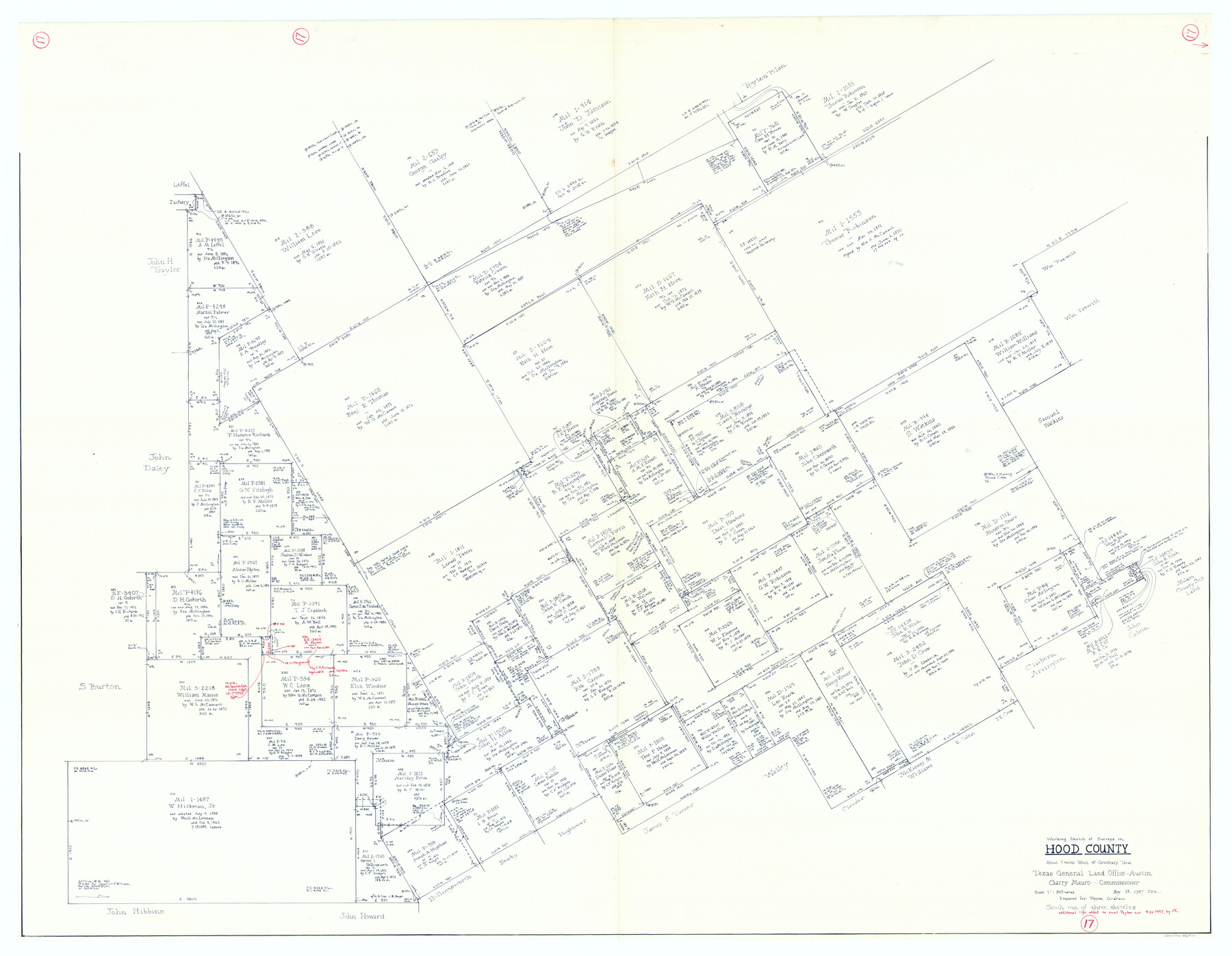
Hood County Working Sketch 17
-
Map/Doc
66211
-
Collection
General Map Collection
-
Object Dates
5/13/1987 (Creation Date)
4/26/1997 (Revision Date)
-
People and Organizations
Joan Kilpatrick (Draftsman)
-
Counties
Hood
-
Subjects
Surveying Working Sketch
-
Height x Width
42.2 x 54.4 inches
107.2 x 138.2 cm
-
Scale
1" = 300 varas
Part of: General Map Collection
Hunt County Sketch File 31

Print $6.00
- Digital $50.00
Hunt County Sketch File 31
1862
Size 9.8 x 8.0 inches
Map/Doc 27135
Grayson County Boundary File 3a

Print $25.00
- Digital $50.00
Grayson County Boundary File 3a
Size 8.3 x 16.9 inches
Map/Doc 53945
Bosque County Sketch File 14

Print $22.00
- Digital $50.00
Bosque County Sketch File 14
1863
Size 12.2 x 7.6 inches
Map/Doc 14763
[Surveys in the Robertson District along the Trinity River and Richland Creek]
![104, [Surveys in the Robertson District along the Trinity River and Richland Creek], General Map Collection](https://historictexasmaps.com/wmedia_w700/maps/104.tif.jpg)
Print $20.00
- Digital $50.00
[Surveys in the Robertson District along the Trinity River and Richland Creek]
1841
Size 15.3 x 12.2 inches
Map/Doc 104
Uvalde County Sketch File 32

Print $12.00
- Digital $50.00
Uvalde County Sketch File 32
2008
Size 8.5 x 11.0 inches
Map/Doc 89025
Ward County Working Sketch 6

Print $20.00
- Digital $50.00
Ward County Working Sketch 6
1945
Size 23.4 x 24.5 inches
Map/Doc 72312
Flight Mission No. DIX-6P, Frame 185, Aransas County

Print $20.00
- Digital $50.00
Flight Mission No. DIX-6P, Frame 185, Aransas County
1956
Size 19.1 x 22.8 inches
Map/Doc 83847
Map of Mexico, Guatimala and the West Indies (Inset: Map of the Country between the cities of Mexico and Vera Cruz)

Print $20.00
- Digital $50.00
Map of Mexico, Guatimala and the West Indies (Inset: Map of the Country between the cities of Mexico and Vera Cruz)
1849
Size 9.5 x 11.8 inches
Map/Doc 93500
Packery Channel

Print $20.00
- Digital $50.00
Packery Channel
1975
Size 26.2 x 21.5 inches
Map/Doc 2991
McMullen County Working Sketch 50

Print $20.00
- Digital $50.00
McMullen County Working Sketch 50
1983
Size 18.4 x 18.0 inches
Map/Doc 70751
Calhoun County Rolled Sketch 14

Print $20.00
- Digital $50.00
Calhoun County Rolled Sketch 14
Size 21.5 x 40.2 inches
Map/Doc 5461
Flight Mission No. CLL-1N, Frame 109, Willacy County

Print $20.00
- Digital $50.00
Flight Mission No. CLL-1N, Frame 109, Willacy County
1954
Size 18.3 x 22.1 inches
Map/Doc 87043
You may also like
Jackson County Rolled Sketch 2

Print $20.00
- Digital $50.00
Jackson County Rolled Sketch 2
Size 14.1 x 17.9 inches
Map/Doc 6335
Wichita County Working Sketch 22

Print $20.00
- Digital $50.00
Wichita County Working Sketch 22
1952
Size 22.2 x 27.1 inches
Map/Doc 72532
Brazos County Rolled Sketch 6

Print $20.00
- Digital $50.00
Brazos County Rolled Sketch 6
1979
Size 24.3 x 36.4 inches
Map/Doc 5190
Upton County Rolled Sketch 23

Print $20.00
- Digital $50.00
Upton County Rolled Sketch 23
1940
Size 25.7 x 39.4 inches
Map/Doc 8074
Clay County Rolled Sketch 4

Print $20.00
- Digital $50.00
Clay County Rolled Sketch 4
1949
Size 32.2 x 25.6 inches
Map/Doc 5486
Glasscock County Sketch File 4

Print $6.00
- Digital $50.00
Glasscock County Sketch File 4
Size 13.3 x 8.8 inches
Map/Doc 24161
Gaines County Sketch File 2M

Print $20.00
- Digital $50.00
Gaines County Sketch File 2M
1902
Size 20.8 x 29.4 inches
Map/Doc 11522
Wheeler County Working Sketch 3

Print $40.00
- Digital $50.00
Wheeler County Working Sketch 3
1972
Size 73.8 x 43.7 inches
Map/Doc 72492
Map of Jefferson County, Texas

Print $20.00
- Digital $50.00
Map of Jefferson County, Texas
1879
Size 23.2 x 20.6 inches
Map/Doc 5054
Andrews County Working Sketch 32

Print $20.00
- Digital $50.00
Andrews County Working Sketch 32
1990
Size 29.6 x 31.5 inches
Map/Doc 67078
Map of the County of Cameron

Print $40.00
- Digital $50.00
Map of the County of Cameron
1884
Size 57.0 x 33.2 inches
Map/Doc 78646
Bowie County Working Sketch 22

Print $40.00
- Digital $50.00
Bowie County Working Sketch 22
1968
Size 49.0 x 37.8 inches
Map/Doc 67426