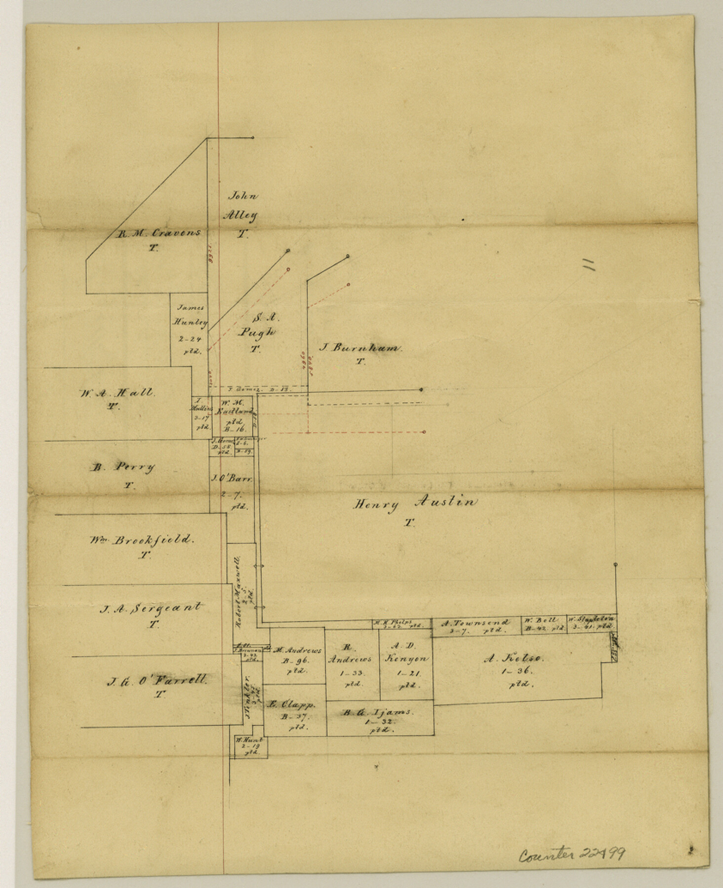
Fayette County Sketch File 2
[Sketch southeast of La Grange around Henry Austin's 5 league grant]
-
Map/Doc
22499
-
Collection
General Map Collection
-
Object Dates
1862/5/21 (Creation Date)
-
People and Organizations
Pressler (Surveyor/Engineer)
-
Counties
Fayette Colorado
-
Subjects
Surveying Sketch File
-
Height x Width
10.3 x 8.4 inches
26.2 x 21.3 cm
-
Medium
paper, manuscript
Part of: General Map Collection
[Corpus Christi Bay and Aransas Bay]
![144, [Corpus Christi Bay and Aransas Bay], General Map Collection](https://historictexasmaps.com/wmedia_w700/maps/144.tif.jpg)
Print $20.00
- Digital $50.00
[Corpus Christi Bay and Aransas Bay]
1840
Size 17.1 x 22.4 inches
Map/Doc 144
Jefferson County

Print $20.00
- Digital $50.00
Jefferson County
1882
Size 22.8 x 20.0 inches
Map/Doc 3730
Medina County Working Sketch 32

Print $20.00
- Digital $50.00
Medina County Working Sketch 32
1994
Size 30.4 x 42.4 inches
Map/Doc 70947
Intracoastal Waterway in Texas - Corpus Christi to Point Isabel including Arroyo Colorado to Mo. Pac. R.R. Bridge Near Harlingen

Print $20.00
- Digital $50.00
Intracoastal Waterway in Texas - Corpus Christi to Point Isabel including Arroyo Colorado to Mo. Pac. R.R. Bridge Near Harlingen
1934
Size 22.0 x 32.7 inches
Map/Doc 61884
United States - Gulf Coast - From Latitude 26° 33' to the Rio Grande Texas

Print $20.00
- Digital $50.00
United States - Gulf Coast - From Latitude 26° 33' to the Rio Grande Texas
1916
Size 27.9 x 18.3 inches
Map/Doc 72838
Webb County Sketch File 2

Print $20.00
- Digital $50.00
Webb County Sketch File 2
Size 20.0 x 18.2 inches
Map/Doc 12612
Jasper County Working Sketch 29

Print $20.00
- Digital $50.00
Jasper County Working Sketch 29
1956
Size 20.6 x 31.4 inches
Map/Doc 66491
Erath County Working Sketch 42

Print $20.00
- Digital $50.00
Erath County Working Sketch 42
1981
Size 23.0 x 23.6 inches
Map/Doc 69123
Starr County Working Sketch 17

Print $20.00
- Digital $50.00
Starr County Working Sketch 17
1982
Size 46.1 x 42.7 inches
Map/Doc 63933
Hall County Sketch File 6

Print $20.00
- Digital $50.00
Hall County Sketch File 6
1885
Size 28.2 x 37.9 inches
Map/Doc 10473
Tom Green County Rolled Sketch 4

Print $20.00
- Digital $50.00
Tom Green County Rolled Sketch 4
Size 28.2 x 23.6 inches
Map/Doc 7994
Presidio County Working Sketch 55

Print $20.00
- Digital $50.00
Presidio County Working Sketch 55
1955
Size 22.0 x 16.9 inches
Map/Doc 71732
You may also like
Map of the Fort Worth and Denver City Railway

Print $40.00
- Digital $50.00
Map of the Fort Worth and Denver City Railway
1873
Size 31.6 x 90.3 inches
Map/Doc 64778
[Area around Gillespie County, Bastrop County and El Paso County School Land Leagues]
![90866, [Area around Gillespie County, Bastrop County and El Paso County School Land Leagues], Twichell Survey Records](https://historictexasmaps.com/wmedia_w700/maps/90866-2.tif.jpg)
Print $20.00
- Digital $50.00
[Area around Gillespie County, Bastrop County and El Paso County School Land Leagues]
1886
Size 25.7 x 29.8 inches
Map/Doc 90866
Maverick County Rolled Sketch 13

Print $20.00
- Digital $50.00
Maverick County Rolled Sketch 13
1848
Size 34.4 x 26.5 inches
Map/Doc 6706
Map of the United States with the contiguous British & Spanish Possessions compiled from the latest & best authorities

Print $40.00
- Digital $50.00
Map of the United States with the contiguous British & Spanish Possessions compiled from the latest & best authorities
1818
Size 36.9 x 59.5 inches
Map/Doc 93843

Flight Mission No. DJV-3P, Frame 15, Ellis County

Print $20.00
- Digital $50.00
Flight Mission No. DJV-3P, Frame 15, Ellis County
1956
Size 18.8 x 22.4 inches
Map/Doc 84977
Liberty County Working Sketch 73

Print $40.00
- Digital $50.00
Liberty County Working Sketch 73
1978
Size 25.5 x 61.6 inches
Map/Doc 70533
Travis County

Print $40.00
- Digital $50.00
Travis County
1936
Size 46.9 x 54.1 inches
Map/Doc 95479
[Surveys along the San Gabriel River]
![78375, [Surveys along the San Gabriel River], General Map Collection](https://historictexasmaps.com/wmedia_w700/maps/78375.tif.jpg)
Print $2.00
- Digital $50.00
[Surveys along the San Gabriel River]
Size 9.0 x 6.3 inches
Map/Doc 78375
Maverick County Sketch File 3a

Print $34.00
- Digital $50.00
Maverick County Sketch File 3a
Size 10.0 x 8.0 inches
Map/Doc 31035
Mills County Working Sketch 18

Print $20.00
- Digital $50.00
Mills County Working Sketch 18
1963
Size 23.2 x 37.0 inches
Map/Doc 71048
General Highway Map, Irion County, Texas

Print $20.00
General Highway Map, Irion County, Texas
1961
Size 18.2 x 24.5 inches
Map/Doc 79531