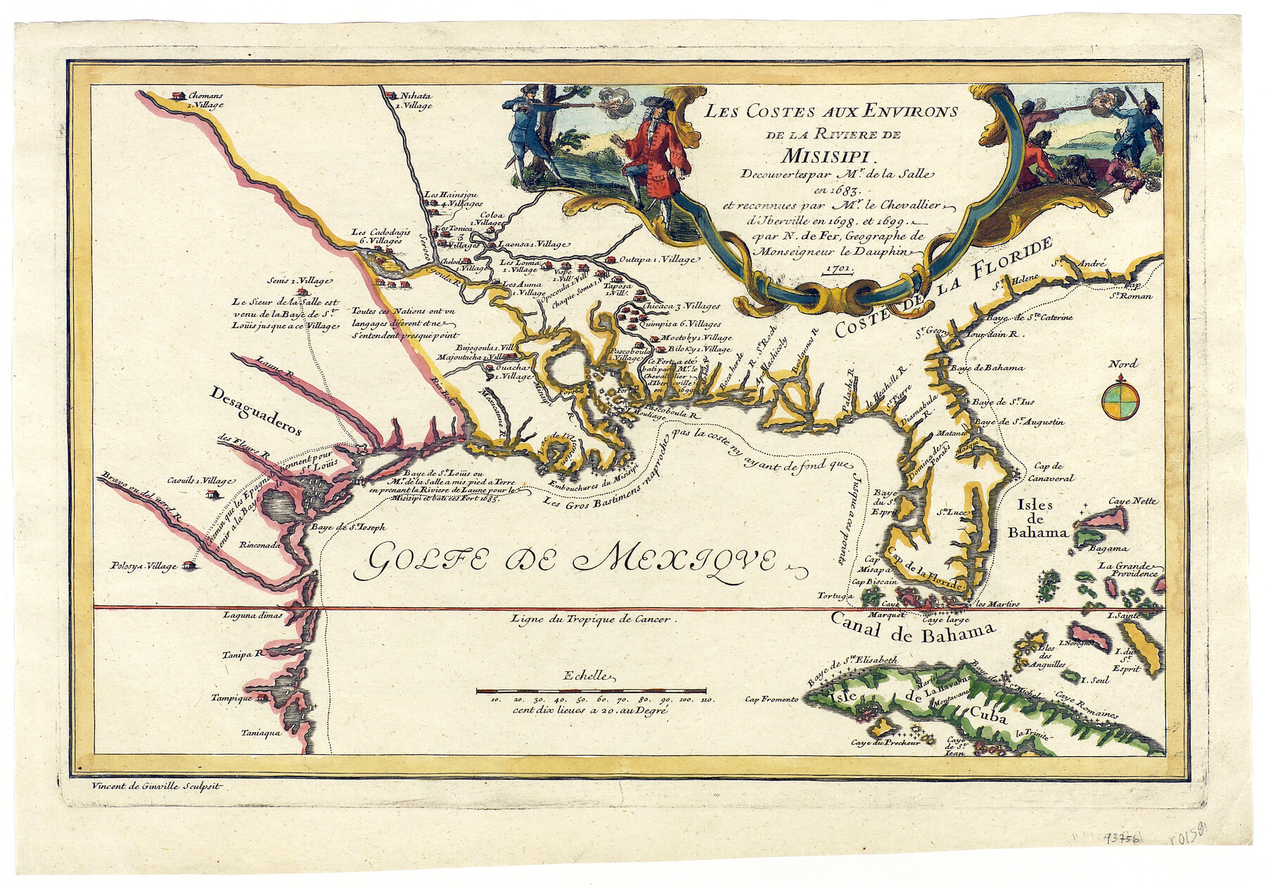
Les costes aux environs de la Riviere de Misisipi decouvertes par M. de la Salle en 1683 et reconnues par M. le Chevallier d'Iberville en 1698 et 1699
-
Map/Doc
93756
-
Collection
General Map Collection
-
Object Dates
1701 (Creation Date)
2015/4/20 (File Date)
-
People and Organizations
Nicolas de Fer (Author)
-
Subjects
Gulf of Mexico North America
-
Height x Width
10.4 x 14.9 inches
26.4 x 37.9 cm
-
Medium
paper
-
Comments
From Nicolas de Fer's "Atlas Curieux"
-
URLs
https://medium.com/@txglo/les-costes-aux-environs-de-la-riviere-de-misisipi-decouvertes-par-m-82bb709a6ac6
Part of: General Map Collection
Coleman County Sketch File 20

Print $4.00
- Digital $50.00
Coleman County Sketch File 20
1871
Size 12.9 x 8.0 inches
Map/Doc 18694
Flight Mission No. DIX-5P, Frame 108, Aransas County

Print $20.00
- Digital $50.00
Flight Mission No. DIX-5P, Frame 108, Aransas County
1956
Size 17.2 x 18.1 inches
Map/Doc 83787
Flight Mission No. DQN-7K, Frame 93, Calhoun County

Print $20.00
- Digital $50.00
Flight Mission No. DQN-7K, Frame 93, Calhoun County
1953
Size 18.4 x 22.2 inches
Map/Doc 84484
Pecos County Working Sketch 122

Print $40.00
- Digital $50.00
Pecos County Working Sketch 122
1973
Size 51.9 x 36.7 inches
Map/Doc 71595
Freestone County Working Sketch 19

Print $20.00
- Digital $50.00
Freestone County Working Sketch 19
1980
Size 39.3 x 44.4 inches
Map/Doc 69261
Uvalde County Sketch File 3

Print $4.00
- Digital $50.00
Uvalde County Sketch File 3
1880
Size 9.1 x 15.0 inches
Map/Doc 38949
Maps of Gulf Intracoastal Waterway, Texas - Sabine River to the Rio Grande and connecting waterways including ship channels

Print $20.00
- Digital $50.00
Maps of Gulf Intracoastal Waterway, Texas - Sabine River to the Rio Grande and connecting waterways including ship channels
1966
Size 14.6 x 22.2 inches
Map/Doc 61971
Nolan County Sketch File 1b

Print $20.00
- Digital $50.00
Nolan County Sketch File 1b
1875
Size 37.6 x 46.7 inches
Map/Doc 10555
Brewster County Rolled Sketch 141

Print $20.00
- Digital $50.00
Brewster County Rolled Sketch 141
1983
Size 27.4 x 28.6 inches
Map/Doc 5309
Pecos County Rolled Sketch 126

Print $20.00
- Digital $50.00
Pecos County Rolled Sketch 126
1948
Size 42.5 x 38.4 inches
Map/Doc 9724
Rusk County Rolled Sketch 8

Print $20.00
- Digital $50.00
Rusk County Rolled Sketch 8
1959
Size 22.6 x 26.3 inches
Map/Doc 7544
Gonzales County Working Sketch 8

Print $20.00
- Digital $50.00
Gonzales County Working Sketch 8
1981
Size 19.0 x 16.7 inches
Map/Doc 63224
You may also like
Val Verde County Sketch File 48

Print $20.00
- Digital $50.00
Val Verde County Sketch File 48
1950
Size 18.2 x 28.9 inches
Map/Doc 12589

Val Verde County

Print $20.00
- Digital $50.00
Val Verde County
1944
Size 41.3 x 36.6 inches
Map/Doc 95661
Duval County Rolled Sketch 20A

Print $20.00
- Digital $50.00
Duval County Rolled Sketch 20A
Size 34.6 x 43.7 inches
Map/Doc 8816

Terrell County Sketch File 36

Print $40.00
- Digital $50.00
Terrell County Sketch File 36
1958
Size 15.7 x 13.5 inches
Map/Doc 37998
Duval County Sketch File 4b

Print $4.00
- Digital $50.00
Duval County Sketch File 4b
1874
Size 10.4 x 7.8 inches
Map/Doc 21282
Jim Wells County Working Sketch 7

Print $20.00
- Digital $50.00
Jim Wells County Working Sketch 7
1944
Size 26.2 x 29.3 inches
Map/Doc 66605
Carson County Sketch File 2

Print $20.00
- Digital $50.00
Carson County Sketch File 2
1888
Size 19.5 x 21.1 inches
Map/Doc 11054
Flight Mission No. DQN-1K, Frame 43, Calhoun County

Print $20.00
- Digital $50.00
Flight Mission No. DQN-1K, Frame 43, Calhoun County
1953
Size 18.6 x 22.3 inches
Map/Doc 84143
Montgomery County Rolled Sketch 18

Print $40.00
- Digital $50.00
Montgomery County Rolled Sketch 18
Size 51.4 x 25.3 inches
Map/Doc 9528
