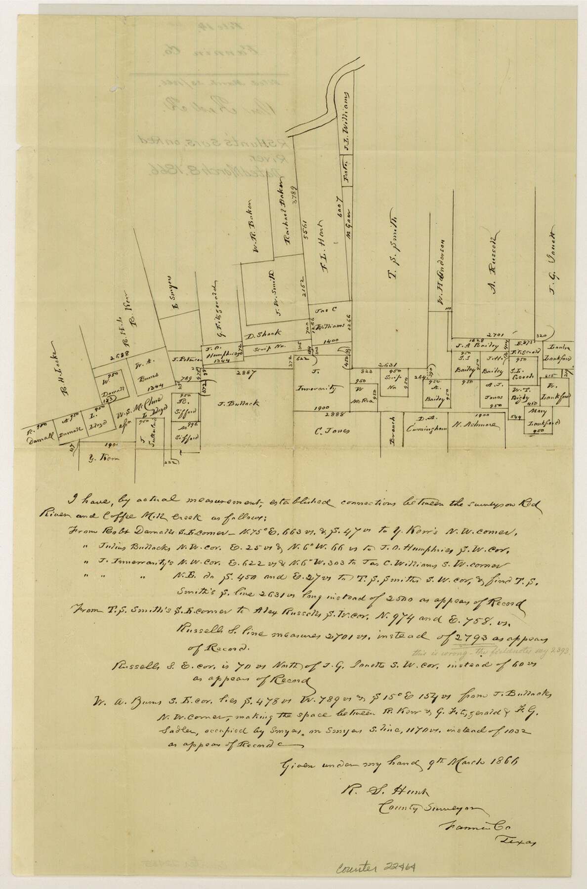
Fannin County Sketch File 14
[Sketch of surveys on Red River]
-
Map/Doc
22464
-
Collection
General Map Collection
-
Object Dates
1866/3/8 (Creation Date)
1866/3/23 (File Date)
-
People and Organizations
R.S. Hunt (Surveyor/Engineer)
-
Counties
Fannin
-
Subjects
Surveying Sketch File
-
Height x Width
14.5 x 9.6 inches
36.8 x 24.4 cm
-
Medium
paper, manuscript
-
Features
Red River
Coffee Mill Creek
Part of: General Map Collection
Orange County Sketch File 43

Print $4.00
- Digital $50.00
Orange County Sketch File 43
1873
Size 8.2 x 10.3 inches
Map/Doc 33385
Lamb County Rolled Sketch 7

Print $20.00
- Digital $50.00
Lamb County Rolled Sketch 7
Size 45.6 x 26.3 inches
Map/Doc 9415
[Gulf Coast of Texas]
![72701, [Gulf Coast of Texas], General Map Collection](https://historictexasmaps.com/wmedia_w700/maps/72701.tif.jpg)
Print $20.00
- Digital $50.00
[Gulf Coast of Texas]
1881
Size 18.2 x 28.5 inches
Map/Doc 72701
San Patricio County Sketch File 15A

Print $4.00
San Patricio County Sketch File 15A
1883
Size 11.0 x 8.5 inches
Map/Doc 97195
Roberts County Working Sketch 36

Print $20.00
- Digital $50.00
Roberts County Working Sketch 36
1978
Size 26.6 x 22.3 inches
Map/Doc 63562
Lubbock County Rolled Sketch 3

Print $20.00
- Digital $50.00
Lubbock County Rolled Sketch 3
Size 25.0 x 38.7 inches
Map/Doc 9469
Coke County Sketch File 32

Print $8.00
- Digital $50.00
Coke County Sketch File 32
1949
Size 11.1 x 8.5 inches
Map/Doc 18645
Brewster County Rolled Sketch 8

Print $40.00
- Digital $50.00
Brewster County Rolled Sketch 8
1878
Size 60.3 x 35.8 inches
Map/Doc 8467
Aransas County Sketch File 31

Print $46.00
- Digital $50.00
Aransas County Sketch File 31
1919
Size 14.2 x 8.7 inches
Map/Doc 13274
Aransas County Working Sketch 6

Print $20.00
- Digital $50.00
Aransas County Working Sketch 6
1943
Size 26.0 x 35.5 inches
Map/Doc 67173
Uvalde County Rolled Sketch 13

Print $20.00
- Digital $50.00
Uvalde County Rolled Sketch 13
Size 38.3 x 32.4 inches
Map/Doc 10065
Val Verde County Working Sketch 20

Print $20.00
- Digital $50.00
Val Verde County Working Sketch 20
1929
Size 30.5 x 20.2 inches
Map/Doc 72155
You may also like
Culberson County Rolled Sketch 1

Print $20.00
- Digital $50.00
Culberson County Rolled Sketch 1
1889
Size 28.7 x 26.4 inches
Map/Doc 5645
Kent County Boundary File 4a

Print $18.00
- Digital $50.00
Kent County Boundary File 4a
Size 14.2 x 8.5 inches
Map/Doc 55838
Hudspeth County Sketch File 21a

Print $10.00
- Digital $50.00
Hudspeth County Sketch File 21a
Size 10.6 x 8.4 inches
Map/Doc 26969
[Maps of surveys in Reeves & Culberson Cos]
![61139, [Maps of surveys in Reeves & Culberson Cos], General Map Collection](https://historictexasmaps.com/wmedia_w700/maps/61139.tif.jpg)
Print $20.00
- Digital $50.00
[Maps of surveys in Reeves & Culberson Cos]
1937
Size 30.7 x 24.7 inches
Map/Doc 61139
Map of Texas Gulf Coast and Continental Shelf showing Natural Gas Pipe Lines

Print $40.00
- Digital $50.00
Map of Texas Gulf Coast and Continental Shelf showing Natural Gas Pipe Lines
1979
Size 40.9 x 59.3 inches
Map/Doc 75905
Colorado County Working Sketch 27

Print $20.00
- Digital $50.00
Colorado County Working Sketch 27
1979
Size 29.1 x 23.3 inches
Map/Doc 68127
Copy of Surveyor's Field Book, Morris Browning - In Blocks 7, 5 & 4, I&GNRRCo., Hutchinson and Carson Counties, Texas

Print $2.00
- Digital $50.00
Copy of Surveyor's Field Book, Morris Browning - In Blocks 7, 5 & 4, I&GNRRCo., Hutchinson and Carson Counties, Texas
1888
Size 7.0 x 8.8 inches
Map/Doc 62272
Jefferson County Sketch File 40

Print $16.00
- Digital $50.00
Jefferson County Sketch File 40
1947
Size 12.3 x 7.9 inches
Map/Doc 28228
Bell County Sketch File 33

Print $6.00
- Digital $50.00
Bell County Sketch File 33
Size 14.4 x 8.7 inches
Map/Doc 14452
Zavala County Boundary File 3

Print $44.00
- Digital $50.00
Zavala County Boundary File 3
Size 9.4 x 7.3 inches
Map/Doc 60258
Martha's Vineyard to Block Island Including Western Approach to Cape Cod Canal

Print $20.00
- Digital $50.00
Martha's Vineyard to Block Island Including Western Approach to Cape Cod Canal
1963
Size 51.1 x 36.9 inches
Map/Doc 73555
Montague County Rolled Sketch 3

Print $20.00
- Digital $50.00
Montague County Rolled Sketch 3
1940
Size 24.0 x 15.9 inches
Map/Doc 6787