Coke County Sketch File 32
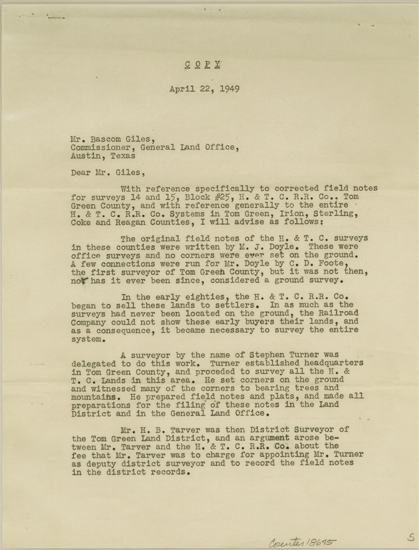
[Report regarding Stephen Turner corners in H. & T. C. R.R. Co. surveys in Tom Green, Irion, Sterling, Coke, and Reagan Counties]
-
Map/Doc
18645
-
Collection
General Map Collection
-
Object Dates
1949/4/22 (Creation Date)
1949/4/28 (File Date)
-
People and Organizations
H.L. George (Surveyor/Engineer)
-
Counties
Coke Tom Green Irion Sterling Reagan
-
Subjects
Surveying Sketch File
-
Height x Width
11.1 x 8.5 inches
28.2 x 21.6 cm
-
Medium
paper, print
Part of: General Map Collection
Andrews County Sketch File 18

Print $12.00
- Digital $50.00
Andrews County Sketch File 18
Size 11.3 x 8.9 inches
Map/Doc 12907
Jefferson County Rolled Sketch 49

Print $40.00
- Digital $50.00
Jefferson County Rolled Sketch 49
1963
Size 30.6 x 57.5 inches
Map/Doc 46415
Corpus Christi Pass

Print $20.00
- Digital $50.00
Corpus Christi Pass
Size 45.7 x 41.2 inches
Map/Doc 78454
Red River County Working Sketch 68

Print $20.00
- Digital $50.00
Red River County Working Sketch 68
1975
Size 20.8 x 26.0 inches
Map/Doc 72051
Map of the Straits of Florida and Gulf of Mexico

Print $20.00
- Digital $50.00
Map of the Straits of Florida and Gulf of Mexico
1851
Size 18.3 x 27.5 inches
Map/Doc 72673
Jack County Sketch File 10

Print $4.00
- Digital $50.00
Jack County Sketch File 10
1857
Size 12.4 x 8.3 inches
Map/Doc 27527
Ochiltree County Sketch File 9

Print $14.00
- Digital $50.00
Ochiltree County Sketch File 9
1934
Size 11.1 x 8.8 inches
Map/Doc 33194
Flight Mission No. BRA-16M, Frame 128, Jefferson County

Print $20.00
- Digital $50.00
Flight Mission No. BRA-16M, Frame 128, Jefferson County
1953
Size 18.6 x 22.7 inches
Map/Doc 85738
Milam County Working Sketch 10

Print $20.00
- Digital $50.00
Milam County Working Sketch 10
1986
Size 25.5 x 34.6 inches
Map/Doc 71025
Layout of the porciones as described in the Visita General of Camargo, 1767

Layout of the porciones as described in the Visita General of Camargo, 1767
2009
Size 11.0 x 8.5 inches
Map/Doc 94041
Pecos County Boundary File 1

Print $2.00
- Digital $50.00
Pecos County Boundary File 1
Size 10.1 x 8.0 inches
Map/Doc 57854
Brown County Rolled Sketch 3

Print $20.00
- Digital $50.00
Brown County Rolled Sketch 3
1985
Size 25.0 x 36.5 inches
Map/Doc 5353
You may also like
Map of Upton County

Print $20.00
- Digital $50.00
Map of Upton County
1899
Size 46.0 x 40.2 inches
Map/Doc 63087
Flight Mission No. BRE-3P, Frame 93, Nueces County

Print $20.00
- Digital $50.00
Flight Mission No. BRE-3P, Frame 93, Nueces County
1956
Size 18.6 x 22.6 inches
Map/Doc 86824
[County School Land Leagues]
![90279, [County School Land Leagues], Twichell Survey Records](https://historictexasmaps.com/wmedia_w700/maps/90279-1.tif.jpg)
Print $20.00
- Digital $50.00
[County School Land Leagues]
1913
Size 21.1 x 27.7 inches
Map/Doc 90279
Hardin County Sketch File 28

Print $4.00
- Digital $50.00
Hardin County Sketch File 28
Size 5.9 x 5.8 inches
Map/Doc 25153
Jefferson County Sketch File 15

Print $10.00
- Digital $50.00
Jefferson County Sketch File 15
1870
Size 8.6 x 7.6 inches
Map/Doc 28151
The Newest Land Of Promise - The Pecos Valley in Texas

Print $20.00
- Digital $50.00
The Newest Land Of Promise - The Pecos Valley in Texas
1900
Size 17.8 x 22.9 inches
Map/Doc 97038
Fort Bend County Rolled Sketch 10

Print $99.00
- Digital $50.00
Fort Bend County Rolled Sketch 10
1958
Size 9.9 x 15.9 inches
Map/Doc 44707
Copy of Surveyor's Field Book, Morris Browning - In Blocks 7, 5 & 4, I&GNRRCo., Hutchinson and Carson Counties, Texas

Print $2.00
- Digital $50.00
Copy of Surveyor's Field Book, Morris Browning - In Blocks 7, 5 & 4, I&GNRRCo., Hutchinson and Carson Counties, Texas
1888
Size 8.9 x 7.1 inches
Map/Doc 62287
Webb County Rolled Sketch D

Print $20.00
- Digital $50.00
Webb County Rolled Sketch D
1897
Size 25.4 x 40.6 inches
Map/Doc 8222
Bosque County Working Sketch 22

Print $40.00
- Digital $50.00
Bosque County Working Sketch 22
1984
Size 38.2 x 54.9 inches
Map/Doc 67455
Swisher County Sketch File 5

Print $8.00
- Digital $50.00
Swisher County Sketch File 5
1876
Size 14.3 x 8.8 inches
Map/Doc 37618
Shackelford County Sketch File 16

Print $24.00
- Digital $50.00
Shackelford County Sketch File 16
2005
Size 16.0 x 16.0 inches
Map/Doc 82982