Falls County Sketch File 26
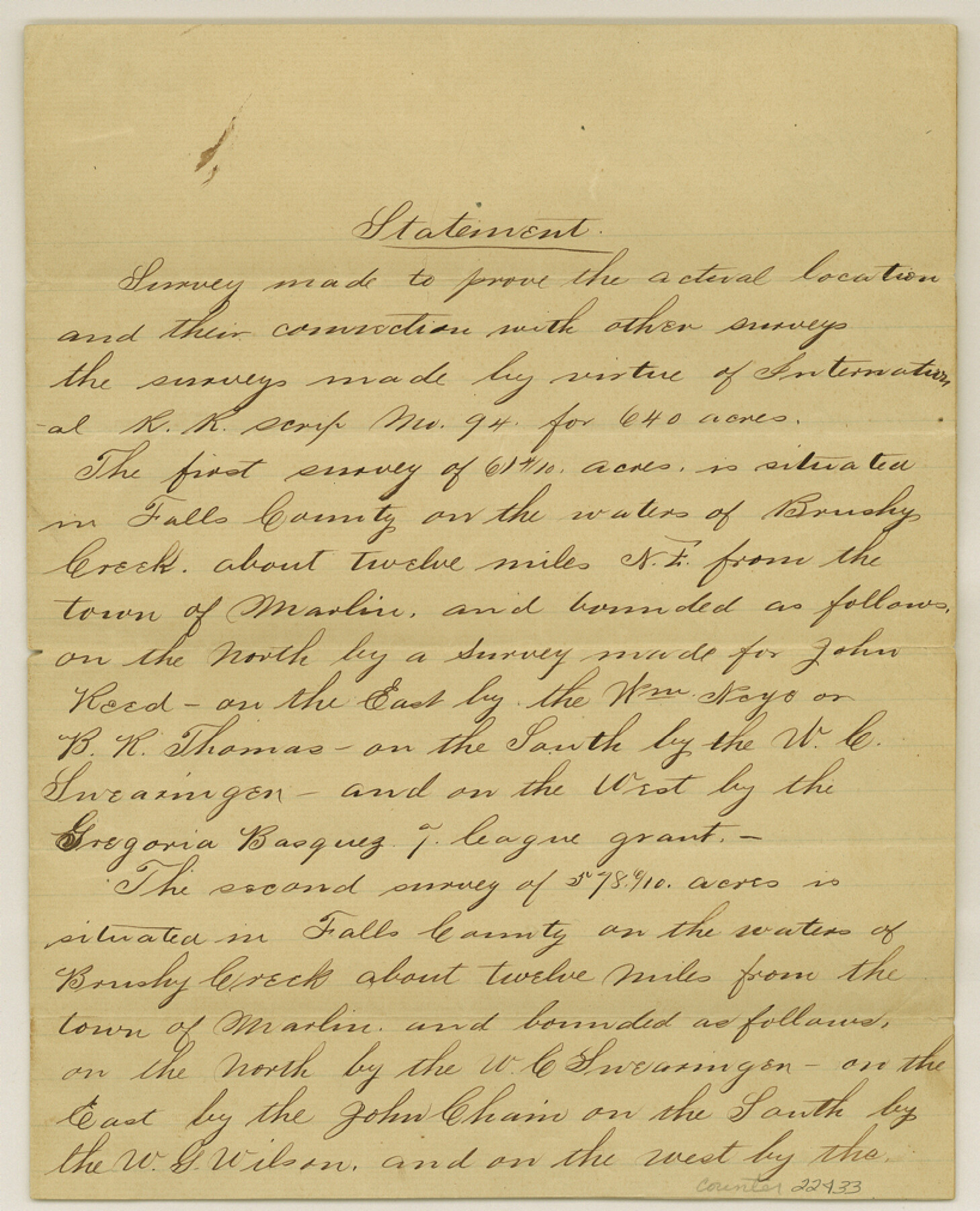
[Statement regarding location of I. & G. N. RR. Co. survey located by virtue of certificate 94]
- 
                          Map/Doc
22433
 - 
                            Collection
General Map Collection
 - 
                            Object Dates
1876/9/25 (Creation Date)
 - 
                            People and Organizations
M.A. Westcott (Surveyor/Engineer)
R.H. Singer (Chainman)
Walter Preston (Chainman)
 - 
                            Counties
Falls
 - 
                            Subjects
Surveying Sketch File
 - 
                            Height x Width
10.1 x 8.2 inches
25.7 x 20.8 cm
 - 
                            Medium
paper, manuscript
 - 
                            Features
Brushy Creek
Marlin
 
Part of: General Map Collection
            [Maps of surveys in Reeves & Culberson Cos]


                                            Print $20.00                    
                                             -                         Digital $50.00                                    
                [Maps of surveys in Reeves & Culberson Cos]
1937
Size 30.6 x 24.9 inches
                                Map/Doc 61140
            
            Val Verde County Sketch File 5


                                            Print $10.00                    
                                             -                         Digital $50.00                                    
                Val Verde County Sketch File 5
1889
Size 11.3 x 8.4 inches
                                Map/Doc 39180
            
            Montgomery County Boundary File 3


                                            Print $6.00                    
                                             -                         Digital $50.00                                    
                Montgomery County Boundary File 3
Size 17.0 x 9.9 inches
                                Map/Doc 57450
            
            Flight Mission No. DCL-6C, Frame 118, Kenedy County


                                            Print $20.00                    
                                             -                         Digital $50.00                                    
                Flight Mission No. DCL-6C, Frame 118, Kenedy County
1943
Size 18.6 x 22.4 inches
                                Map/Doc 85948
            
            Webb County Rolled Sketch 68


                                            Print $43.00                    
                                             -                         Digital $50.00                                    
                Webb County Rolled Sketch 68
1910
Size 9.6 x 15.1 inches
                                Map/Doc 49485
            
            Proceedings of The International (Water) Boundary Commission United States and Mexico Treaties of 1884 and 1889, Volume 1


            Proceedings of The International (Water) Boundary Commission United States and Mexico Treaties of 1884 and 1889, Volume 1
Map/Doc 83146
            
            Flight Mission No. CRC-2R, Frame 119, Chambers County


                                            Print $20.00                    
                                             -                         Digital $50.00                                    
                Flight Mission No. CRC-2R, Frame 119, Chambers County
1956
Size 18.6 x 22.4 inches
                                Map/Doc 84743
            
            Throckmorton County Boundary File 3


                                            Print $40.00                    
                                             -                         Digital $50.00                                    
                Throckmorton County Boundary File 3
Size 18.9 x 17.9 inches
                                Map/Doc 59281
            
            Haskell County Sketch File 7


                                            Print $22.00                    
                                             -                         Digital $50.00                                    
                Haskell County Sketch File 7
Size 7.8 x 13.4 inches
                                Map/Doc 26128
            
            Brown County Sketch File 2


                                            Print $4.00                    
                                             -                         Digital $50.00                                    
                Brown County Sketch File 2
Size 11.8 x 8.1 inches
                                Map/Doc 16582
            
            Upton County Sketch File 36


                                            Print $14.00                    
                                             -                         Digital $50.00                                    
                Upton County Sketch File 36
1952
Size 11.3 x 8.8 inches
                                Map/Doc 38893
            You may also like
            Flight Mission No. BRE-1P, Frame 50, Nueces County


                                            Print $20.00                    
                                             -                         Digital $50.00                                    
                Flight Mission No. BRE-1P, Frame 50, Nueces County
1956
Size 18.5 x 22.3 inches
                                Map/Doc 86639
            
            Map of Trinity Co.


                                            Print $20.00                    
                                             -                         Digital $50.00                                    
                Map of Trinity Co.
1896
Size 41.3 x 38.3 inches
                                Map/Doc 78446
            
            Starr County Rolled Sketch 40


                                            Print $20.00                    
                                             -                         Digital $50.00                                    
                Starr County Rolled Sketch 40
1961
Size 21.3 x 22.6 inches
                                Map/Doc 7834
            
            Brazoria County NRC Article 33.136 Sketch 1


                                            Print $20.00                    
                                             -                         Digital $50.00                                    
                Brazoria County NRC Article 33.136 Sketch 1
2000
Size 24.7 x 35.9 inches
                                Map/Doc 61555
            
            Sutton County Rolled Sketch F


                                            Print $20.00                    
                                             -                         Digital $50.00                                    
                Sutton County Rolled Sketch F
Size 12.7 x 38.9 inches
                                Map/Doc 7903
            
            Gray County Working Sketch Graphic Index


                                            Print $20.00                    
                                             -                         Digital $50.00                                    
                Gray County Working Sketch Graphic Index
1900
Size 43.3 x 39.4 inches
                                Map/Doc 76557
            
            General Highway Map Cochran County, Texas


                                            Print $20.00                    
                                             -                         Digital $50.00                                    
                General Highway Map Cochran County, Texas
1948
Size 18.7 x 25.6 inches
                                Map/Doc 92498
            
            Collingsworth County Working Sketch 2


                                            Print $20.00                    
                                             -                         Digital $50.00                                    
                Collingsworth County Working Sketch 2
1957
Size 10.2 x 32.6 inches
                                Map/Doc 63762
            
            Flight Mission No. CGI-4N, Frame 22, Cameron County


                                            Print $20.00                    
                                             -                         Digital $50.00                                    
                Flight Mission No. CGI-4N, Frame 22, Cameron County
1954
Size 18.5 x 22.3 inches
                                Map/Doc 84655
            
            Flight Mission No. DAG-21K, Frame 34, Matagorda County


                                            Print $20.00                    
                                             -                         Digital $50.00                                    
                Flight Mission No. DAG-21K, Frame 34, Matagorda County
1952
Size 18.7 x 22.3 inches
                                Map/Doc 86401
            
            Hudspeth County Sketch File 11a


                                            Print $8.00                    
                                             -                         Digital $50.00                                    
                Hudspeth County Sketch File 11a
Size 14.3 x 9.0 inches
                                Map/Doc 26910
            
            Montague County Working Sketch 25


                                            Print $20.00                    
                                             -                         Digital $50.00                                    
                Montague County Working Sketch 25
1955
Size 42.4 x 28.4 inches
                                Map/Doc 71091