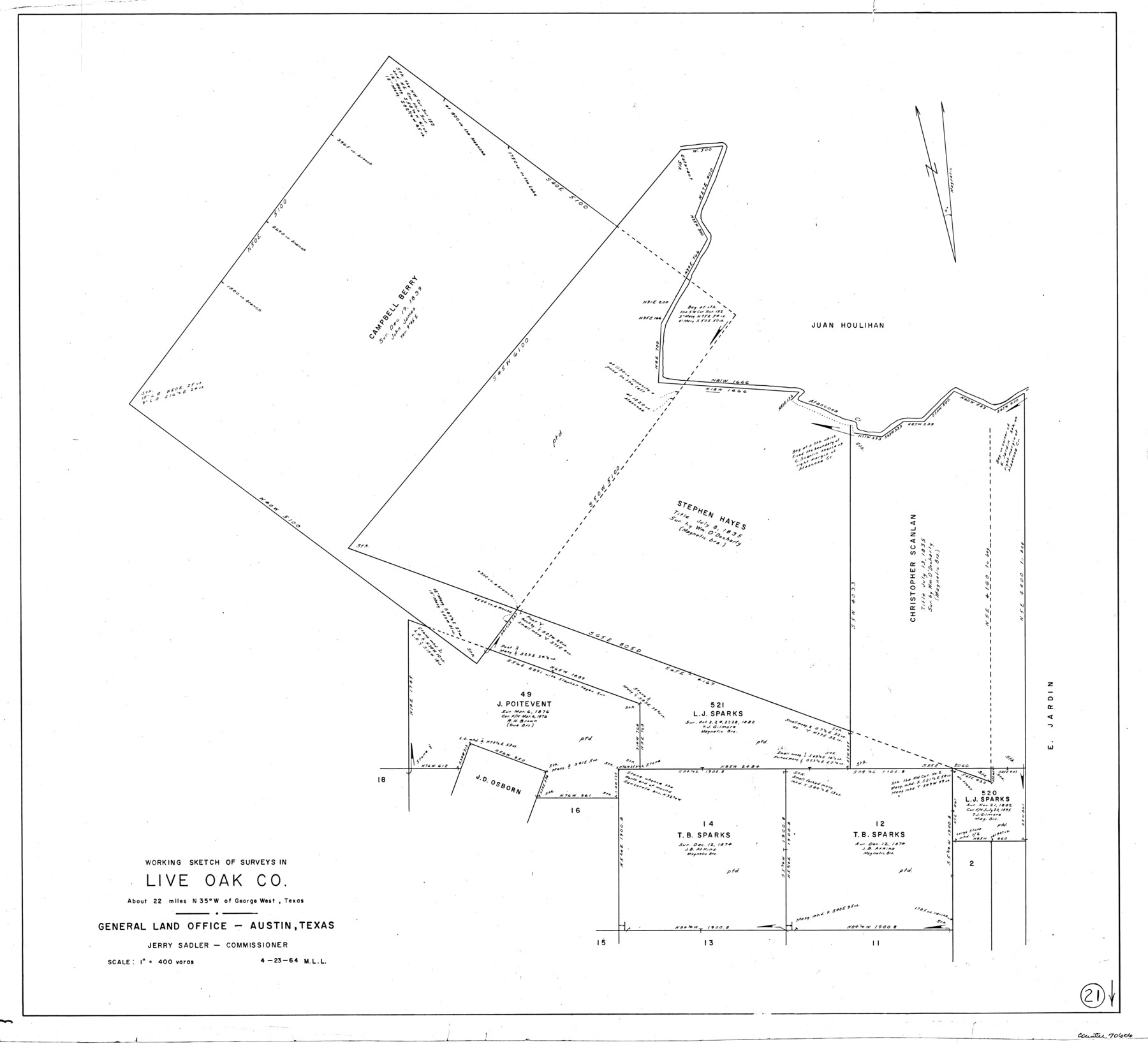
Live Oak County Working Sketch 21
-
Map/Doc
70606
-
Collection
General Map Collection
-
Object Dates
4/23/1964 (Creation Date)
-
People and Organizations
M. L. Liles (Draftsman)
-
Counties
Live Oak
-
Subjects
Surveying Working Sketch
-
Height x Width
30.8 x 33.9 inches
78.2 x 86.1 cm
-
Scale
1" = 400 varas
Part of: General Map Collection
Hartley County Boundary File 2

Print $52.00
- Digital $50.00
Hartley County Boundary File 2
Size 8.8 x 24.8 inches
Map/Doc 54453

Flight Mission No. DQN-7K, Frame 94, Calhoun County

Print $20.00
- Digital $50.00
Flight Mission No. DQN-7K, Frame 94, Calhoun County
1953
Size 18.6 x 22.1 inches
Map/Doc 84485
Aransas County Rolled Sketch 25A-25E

Print $20.00
- Digital $50.00
Aransas County Rolled Sketch 25A-25E
Size 24.6 x 39.5 inches
Map/Doc 76078
Map of Mexico, Including Yucatan & Upper California, exhibiting the Chief Cities and Towns, the Principal Travelling Routes &c.

Print $20.00
- Digital $50.00
Map of Mexico, Including Yucatan & Upper California, exhibiting the Chief Cities and Towns, the Principal Travelling Routes &c.
Size 33.3 x 25.4 inches
Map/Doc 95697
Jack County Sketch File 13

Print $4.00
- Digital $50.00
Jack County Sketch File 13
Size 10.3 x 8.0 inches
Map/Doc 27537
Grimes County Working Sketch 11

Print $20.00
- Digital $50.00
Grimes County Working Sketch 11
1981
Size 22.7 x 22.6 inches
Map/Doc 63302
Zapata County Rolled Sketch 4

Print $20.00
- Digital $50.00
Zapata County Rolled Sketch 4
1884
Size 15.6 x 13.8 inches
Map/Doc 8306
Galveston County Sketch File 26

Print $4.00
- Digital $50.00
Galveston County Sketch File 26
1860
Size 11.8 x 5.7 inches
Map/Doc 23397
Blanco County Working Sketch 9

Print $20.00
- Digital $50.00
Blanco County Working Sketch 9
1935
Size 11.3 x 18.0 inches
Map/Doc 67369
Guadalupe County Sketch File 7

Print $20.00
- Digital $50.00
Guadalupe County Sketch File 7
Size 15.6 x 19.5 inches
Map/Doc 11590
Stonewall County Rolled Sketch 7

Print $20.00
- Digital $50.00
Stonewall County Rolled Sketch 7
1890
Size 16.6 x 37.9 inches
Map/Doc 7864
You may also like
Reeves County Working Sketch 5

Print $20.00
- Digital $50.00
Reeves County Working Sketch 5
1938
Size 38.0 x 32.4 inches
Map/Doc 63448
[Map Showing J. H. Kemble Sections]
![92893, [Map Showing J. H. Kemble Sections], Twichell Survey Records](https://historictexasmaps.com/wmedia_w700/maps/92893-1.tif.jpg)
Print $20.00
- Digital $50.00
[Map Showing J. H. Kemble Sections]
Size 17.8 x 22.3 inches
Map/Doc 92893
Right of Way and Track Map, The Wichita Falls & Southern Railway

Print $40.00
- Digital $50.00
Right of Way and Track Map, The Wichita Falls & Southern Railway
1942
Size 25.5 x 92.5 inches
Map/Doc 64513
A New Map of ye North Parts of America according to the division thereof by the Articles of Peace in 1763

Print $20.00
A New Map of ye North Parts of America according to the division thereof by the Articles of Peace in 1763
1763
Size 8.5 x 11.3 inches
Map/Doc 95280
Dawson County

Print $20.00
- Digital $50.00
Dawson County
1959
Size 43.5 x 35.1 inches
Map/Doc 77259
A New Map of Texas with the Contiguous American & Mexican States

Print $20.00
- Digital $50.00
A New Map of Texas with the Contiguous American & Mexican States
1837
Size 12.5 x 15.1 inches
Map/Doc 96643
Sketch Showing Reed and Meeker Vacancy, Cochran County, Texas

Print $20.00
- Digital $50.00
Sketch Showing Reed and Meeker Vacancy, Cochran County, Texas
Size 28.9 x 20.3 inches
Map/Doc 92514
Pecos County Rolled Sketch 62

Print $20.00
- Digital $50.00
Pecos County Rolled Sketch 62
1927
Size 44.2 x 39.4 inches
Map/Doc 9698
Flight Mission No. DQN-2K, Frame 73, Calhoun County

Print $20.00
- Digital $50.00
Flight Mission No. DQN-2K, Frame 73, Calhoun County
1953
Size 18.5 x 22.2 inches
Map/Doc 84265
Angelina County, Texas

Print $20.00
- Digital $50.00
Angelina County, Texas
1879
Size 21.8 x 28.0 inches
Map/Doc 687
Flight Mission No. BQY-14M, Frame 180, Harris County

Print $20.00
- Digital $50.00
Flight Mission No. BQY-14M, Frame 180, Harris County
1953
Size 18.6 x 22.4 inches
Map/Doc 85296
Set of new maps of Austin's Colony by G. Borden, Jr.

Print $20.00
- Digital $50.00
Set of new maps of Austin's Colony by G. Borden, Jr.
1833
Size 25.0 x 17.0 inches
Map/Doc 131