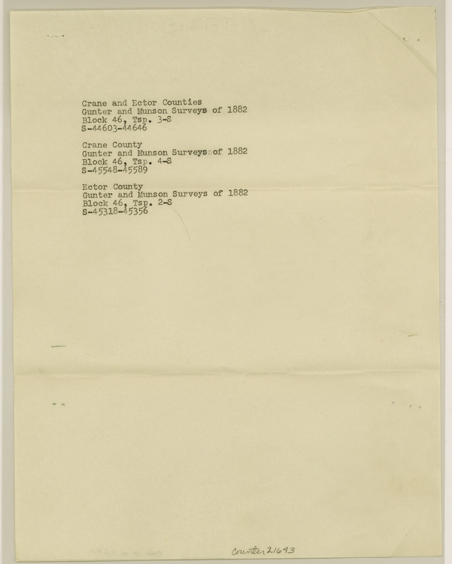
Ector County Sketch File 11
[List of files of Gunter and Munson surveys of 1882, Block 46]
-
Map/Doc
21643
-
Collection
General Map Collection
-
Object Dates
1950/8/10 (File Date)
-
Counties
Ector
-
Subjects
Surveying Sketch File
-
Height x Width
11.3 x 9.0 inches
28.7 x 22.9 cm
-
Medium
paper, print
Part of: General Map Collection
Tom Green County Sketch File 60

Print $20.00
- Digital $50.00
Tom Green County Sketch File 60
1888
Size 28.4 x 25.9 inches
Map/Doc 12444
Dimmit County Working Sketch 9

Print $20.00
- Digital $50.00
Dimmit County Working Sketch 9
1934
Size 36.3 x 42.2 inches
Map/Doc 68670
El Paso County Boundary File 2

Print $28.00
- Digital $50.00
El Paso County Boundary File 2
Size 13.2 x 8.2 inches
Map/Doc 53021
Edwards County Sketch File 2 and 3

Print $8.00
- Digital $50.00
Edwards County Sketch File 2 and 3
1874
Size 9.3 x 4.1 inches
Map/Doc 21676
Henderson County Rolled Sketch 11

Print $20.00
- Digital $50.00
Henderson County Rolled Sketch 11
1915
Size 29.4 x 42.5 inches
Map/Doc 75946
El Paso County Rolled Sketch 52

Print $20.00
- Digital $50.00
El Paso County Rolled Sketch 52
1929
Size 18.5 x 24.5 inches
Map/Doc 5847
Flight Mission No. CRK-8P, Frame 99, Refugio County

Print $20.00
- Digital $50.00
Flight Mission No. CRK-8P, Frame 99, Refugio County
1956
Size 18.3 x 22.1 inches
Map/Doc 86960
United States Atlantic and Gulf Coasts Including Puerto Rico and the Virgin Islands

Print $40.00
- Digital $50.00
United States Atlantic and Gulf Coasts Including Puerto Rico and the Virgin Islands
1992
Size 21.7 x 60.7 inches
Map/Doc 76123
Gray County Boundary File 3

Print $40.00
- Digital $50.00
Gray County Boundary File 3
Size 14.2 x 8.8 inches
Map/Doc 53854
Armstrong County Working Sketch 8

Print $20.00
- Digital $50.00
Armstrong County Working Sketch 8
1902
Size 25.4 x 40.2 inches
Map/Doc 67239
Texas City Channel, Texas, Channel and Turning Basin Dredging - Sheet 2

Print $20.00
- Digital $50.00
Texas City Channel, Texas, Channel and Turning Basin Dredging - Sheet 2
1958
Size 28.6 x 41.0 inches
Map/Doc 61832
Brazoria County Sketch File 14

Print $8.00
- Digital $50.00
Brazoria County Sketch File 14
1892
Size 13.9 x 8.7 inches
Map/Doc 14973
You may also like
Hunt County Sketch File 16a

Print $4.00
- Digital $50.00
Hunt County Sketch File 16a
Size 4.6 x 8.1 inches
Map/Doc 27109
[Sketch for Mineral Application 26546 - Sabine River between Hawkins Creek and east boundary line of BBB&C RR Co. Surveys, R. S. Rathke]
![65665, [Sketch for Mineral Application 26546 - Sabine River between Hawkins Creek and east boundary line of BBB&C RR Co. Surveys, R. S. Rathke], General Map Collection](https://historictexasmaps.com/wmedia_w700/maps/65665.tif.jpg)
Print $40.00
- Digital $50.00
[Sketch for Mineral Application 26546 - Sabine River between Hawkins Creek and east boundary line of BBB&C RR Co. Surveys, R. S. Rathke]
1931
Size 25.5 x 75.1 inches
Map/Doc 65665
[Capitol Leagues 217-228, 238, and vicinity]
![90695, [Capitol Leagues 217-228, 238, and vicinity], Twichell Survey Records](https://historictexasmaps.com/wmedia_w700/maps/90695-1.tif.jpg)
Print $20.00
- Digital $50.00
[Capitol Leagues 217-228, 238, and vicinity]
Size 23.8 x 12.9 inches
Map/Doc 90695
Pecos County Sketch File 104

Print $36.00
- Digital $50.00
Pecos County Sketch File 104
1966
Size 11.3 x 8.7 inches
Map/Doc 34020
Uvalde County Working Sketch 64, revised

Print $20.00
- Digital $50.00
Uvalde County Working Sketch 64, revised
1998
Size 34.2 x 35.5 inches
Map/Doc 72135
Zavala County Boundary File 2a

Print $56.00
- Digital $50.00
Zavala County Boundary File 2a
Size 14.2 x 8.8 inches
Map/Doc 60248
Mrs. John H. Dean Ranch, Cochran County, Texas

Print $20.00
- Digital $50.00
Mrs. John H. Dean Ranch, Cochran County, Texas
Size 25.4 x 21.1 inches
Map/Doc 92516
Pecos County Rolled Sketch 82

Print $20.00
- Digital $50.00
Pecos County Rolled Sketch 82
1930
Size 28.3 x 25.8 inches
Map/Doc 10191
Carta Agricola

Print $20.00
- Digital $50.00
Carta Agricola
1897
Size 26.0 x 34.3 inches
Map/Doc 96804
Yoakum County

Print $20.00
- Digital $50.00
Yoakum County
1902
Size 46.1 x 36.6 inches
Map/Doc 63138
Map of Grimes County

Print $20.00
- Digital $50.00
Map of Grimes County
1858
Size 29.1 x 21.4 inches
Map/Doc 3605
Plat of a survey on Padre Island in Willacy and Kenedy Counties surveyed for South Padre Development Corporation by Settles and Claunch

Print $40.00
- Digital $50.00
Plat of a survey on Padre Island in Willacy and Kenedy Counties surveyed for South Padre Development Corporation by Settles and Claunch
1966
Size 53.6 x 40.9 inches
Map/Doc 61425