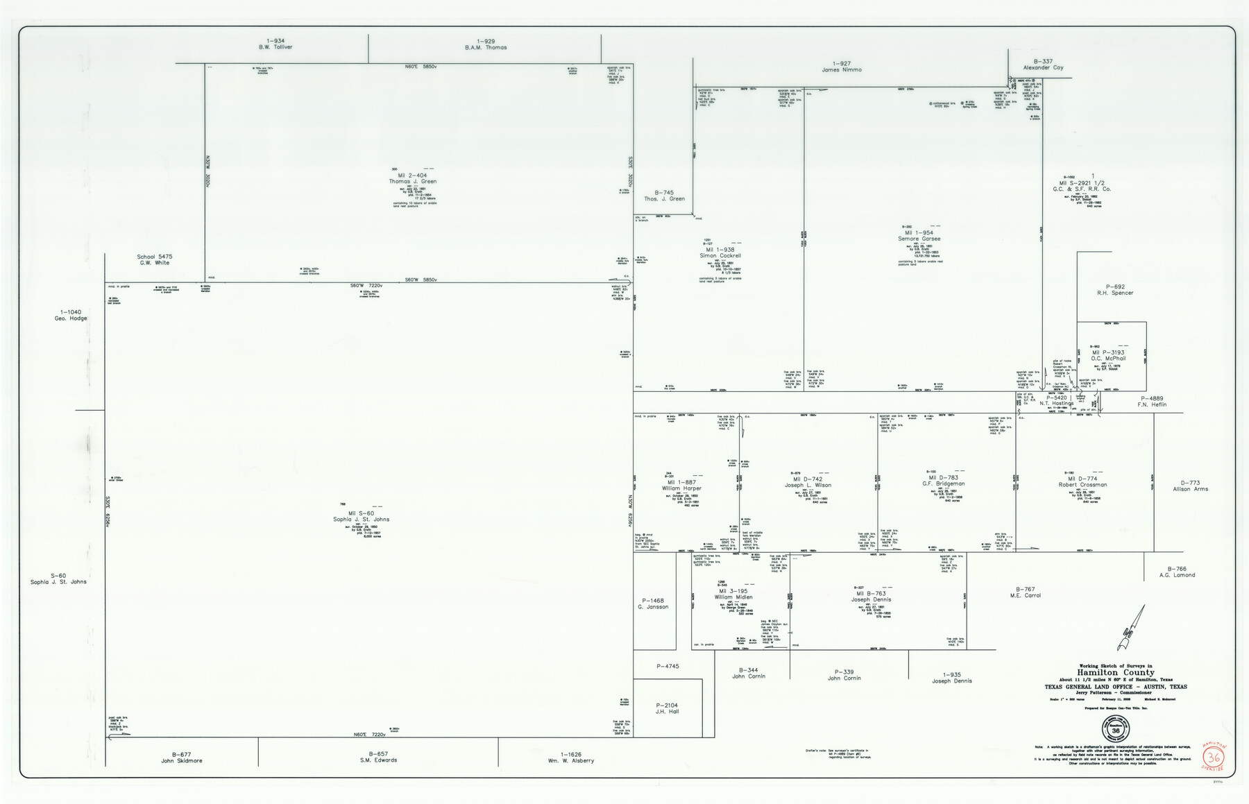
Hamilton County Working Sketch 36
-
Map/Doc
88996
-
Collection
General Map Collection
-
Object Dates
2/11/2008 (Creation Date)
-
People and Organizations
Jerry E. Patterson (GLO Commissioner)
Michael R. Mokarzel (Draftsman)
-
Counties
Hamilton Bosque
-
Subjects
Surveying Working Sketch
-
Height x Width
36.9 x 57.3 inches
93.7 x 145.5 cm
-
Scale
1" = 300 varas
Part of: General Map Collection
Edwards County Sketch File 43

Print $20.00
- Digital $50.00
Edwards County Sketch File 43
1947
Size 17.4 x 18.2 inches
Map/Doc 11441
Atascosa County Sketch File 35

Print $20.00
- Digital $50.00
Atascosa County Sketch File 35
1854
Size 14.4 x 30.0 inches
Map/Doc 10866
Taylor County Sketch File 1

Print $20.00
- Digital $50.00
Taylor County Sketch File 1
Size 33.3 x 40.8 inches
Map/Doc 10381
Flight Mission No. CUG-1P, Frame 42, Kleberg County

Print $20.00
- Digital $50.00
Flight Mission No. CUG-1P, Frame 42, Kleberg County
1956
Size 18.9 x 22.5 inches
Map/Doc 86120
Flight Mission No. BRE-5P, Frame 199, Nueces County

Print $20.00
- Digital $50.00
Flight Mission No. BRE-5P, Frame 199, Nueces County
1956
Size 18.4 x 22.3 inches
Map/Doc 86839
Rusk County Working Sketch 27

Print $20.00
- Digital $50.00
Rusk County Working Sketch 27
1937
Size 35.6 x 29.3 inches
Map/Doc 63663
Collin County Sketch File 2

Print $8.00
- Digital $50.00
Collin County Sketch File 2
1848
Size 10.0 x 8.0 inches
Map/Doc 18858
Map of Menard County

Print $20.00
- Digital $50.00
Map of Menard County
1871
Size 18.5 x 23.3 inches
Map/Doc 3872
Atascosa County Rolled Sketch 15

Print $20.00
- Digital $50.00
Atascosa County Rolled Sketch 15
1945
Size 45.2 x 42.7 inches
Map/Doc 8433
Flight Mission No. DQO-2K, Frame 101, Galveston County

Print $20.00
- Digital $50.00
Flight Mission No. DQO-2K, Frame 101, Galveston County
1952
Size 18.8 x 22.5 inches
Map/Doc 85028
Gregg County Working Sketch 14

Print $20.00
- Digital $50.00
Gregg County Working Sketch 14
1941
Size 29.7 x 39.5 inches
Map/Doc 63281
Wilbarger County Sketch File 20

Print $4.00
- Digital $50.00
Wilbarger County Sketch File 20
1885
Size 12.7 x 8.2 inches
Map/Doc 40217
You may also like

[Sketch showing T. & N. O. Blocks 3T and 6T, Denison and Pacific RR. Co. Block O-18 and surrounding areas]
![93001, [Sketch showing T. & N. O. Blocks 3T and 6T, Denison and Pacific RR. Co. Block O-18 and surrounding areas], Twichell Survey Records](https://historictexasmaps.com/wmedia_w700/maps/93001-1.tif.jpg)
Print $20.00
- Digital $50.00
[Sketch showing T. & N. O. Blocks 3T and 6T, Denison and Pacific RR. Co. Block O-18 and surrounding areas]
Size 21.0 x 28.5 inches
Map/Doc 93001
Loving County Working Sketch 15

Print $20.00
- Digital $50.00
Loving County Working Sketch 15
1973
Size 47.3 x 34.5 inches
Map/Doc 70648
DeWitt County Sketch File 5

Print $4.00
- Digital $50.00
DeWitt County Sketch File 5
1872
Size 13.0 x 8.3 inches
Map/Doc 20803
Callahan County Sketch File 17

Print $18.00
- Digital $50.00
Callahan County Sketch File 17
Size 11.0 x 8.5 inches
Map/Doc 93444
Leon County Rolled Sketch 28

Print $20.00
- Digital $50.00
Leon County Rolled Sketch 28
1993
Size 35.8 x 46.6 inches
Map/Doc 9438
Jefferson County Sketch File 32

Print $4.00
- Digital $50.00
Jefferson County Sketch File 32
1900
Size 11.3 x 8.7 inches
Map/Doc 28195
Cass County Sketch File 4

Print $6.00
- Digital $50.00
Cass County Sketch File 4
1853
Size 8.2 x 11.2 inches
Map/Doc 17398
Galveston Bay Oil Area, Galveston, Harris, Chambers and Brazoria Cos.

Print $40.00
- Digital $50.00
Galveston Bay Oil Area, Galveston, Harris, Chambers and Brazoria Cos.
1927
Size 52.9 x 40.8 inches
Map/Doc 2938
Menard County

Print $20.00
- Digital $50.00
Menard County
1942
Size 43.6 x 47.7 inches
Map/Doc 77371
Montague County Working Sketch 21

Print $20.00
- Digital $50.00
Montague County Working Sketch 21
1952
Size 33.1 x 39.5 inches
Map/Doc 71087
Foard County Rolled Sketch 15A

Print $20.00
- Digital $50.00
Foard County Rolled Sketch 15A
1889
Size 37.3 x 39.8 inches
Map/Doc 75936