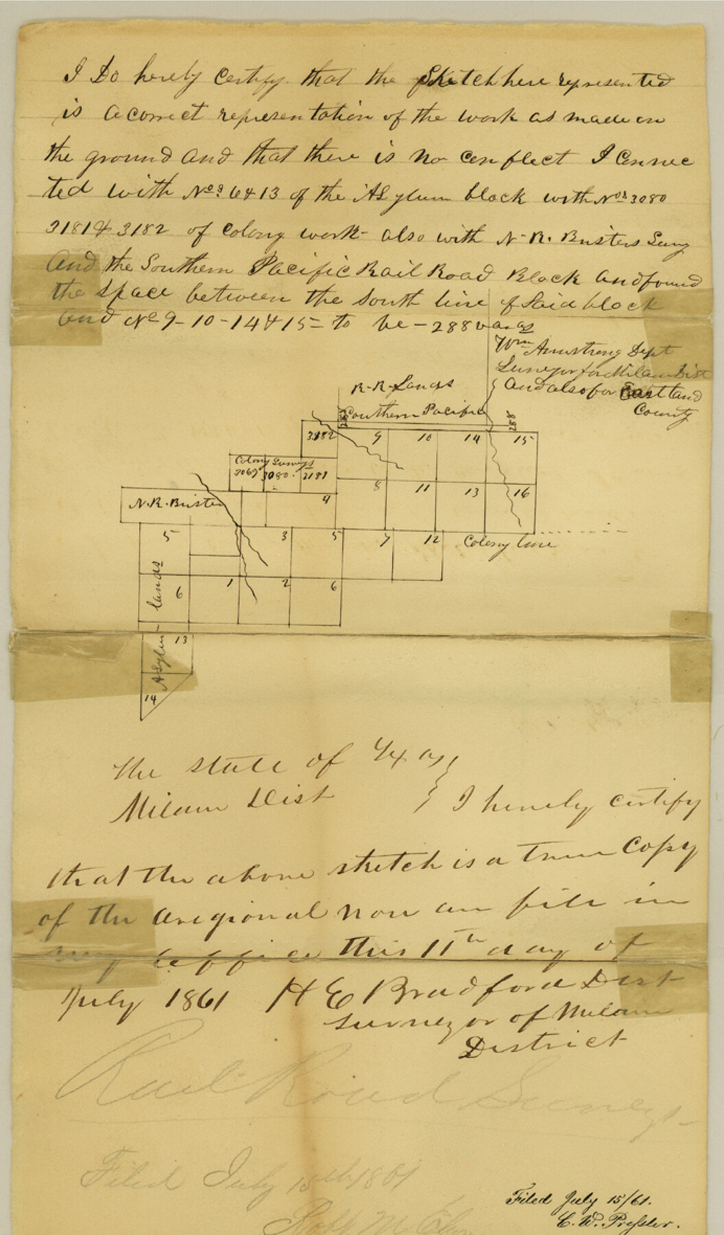
Eastland County Sketch File 4
[Sketch and explanation of surveys west of Center]
-
Map/Doc
21568
-
Collection
General Map Collection
-
Object Dates
1861/7/11 (Creation Date)
1861/7/15 (File Date)
-
People and Organizations
William Armstrong (Surveyor/Engineer)
-
Counties
Eastland
-
Subjects
Surveying Sketch File
-
Height x Width
11.8 x 6.9 inches
30.0 x 17.5 cm
-
Medium
paper, manuscript
Part of: General Map Collection
El Paso County Rolled Sketch 52

Print $20.00
- Digital $50.00
El Paso County Rolled Sketch 52
1929
Size 18.5 x 24.4 inches
Map/Doc 5838
Crockett County Sketch File 94

Print $6.00
- Digital $50.00
Crockett County Sketch File 94
1940
Size 9.2 x 12.3 inches
Map/Doc 19950
Current Miscellaneous File 12

Print $34.00
- Digital $50.00
Current Miscellaneous File 12
1951
Size 10.7 x 8.2 inches
Map/Doc 73803
Ellis County Sketch File 22

Print $2.00
- Digital $50.00
Ellis County Sketch File 22
1857
Size 8.0 x 4.0 inches
Map/Doc 88797
Current Miscellaneous File 82

Print $4.00
- Digital $50.00
Current Miscellaneous File 82
Size 12.0 x 8.8 inches
Map/Doc 74224
Deaf Smith County Rolled Sketch 2

Print $20.00
- Digital $50.00
Deaf Smith County Rolled Sketch 2
1976
Size 42.7 x 14.4 inches
Map/Doc 5699
Fort Bend County Rolled Sketch B

Print $20.00
- Digital $50.00
Fort Bend County Rolled Sketch B
Size 20.4 x 28.9 inches
Map/Doc 5904
Hutchinson County Sketch File 10

Print $40.00
- Digital $50.00
Hutchinson County Sketch File 10
Size 55.8 x 9.2 inches
Map/Doc 10500
Webb County Working Sketch 87

Print $20.00
- Digital $50.00
Webb County Working Sketch 87
1981
Size 46.3 x 39.6 inches
Map/Doc 72454
Red River County Sketch File 11

Print $4.00
- Digital $50.00
Red River County Sketch File 11
Size 11.8 x 8.1 inches
Map/Doc 35127

McLennan County Sketch File 15

Print $4.00
- Digital $50.00
McLennan County Sketch File 15
1872
Size 8.2 x 11.3 inches
Map/Doc 31274
You may also like
Bandera County

Print $40.00
- Digital $50.00
Bandera County
1947
Size 33.9 x 54.9 inches
Map/Doc 73075
Austin Map and Street Guide [Verso]
![94163, Austin Map and Street Guide [Verso], General Map Collection](https://historictexasmaps.com/wmedia_w700/maps/94163.tif.jpg)
Austin Map and Street Guide [Verso]
1986
Size 35.5 x 22.8 inches
Map/Doc 94163
[Galveston, Harrisburg & San Antonio Railroad from Cuero to Stockdale]
![64202, [Galveston, Harrisburg & San Antonio Railroad from Cuero to Stockdale], General Map Collection](https://historictexasmaps.com/wmedia_w700/maps/64202.tif.jpg)
Print $20.00
- Digital $50.00
[Galveston, Harrisburg & San Antonio Railroad from Cuero to Stockdale]
1907
Size 13.3 x 33.1 inches
Map/Doc 64202
Howard County Working Sketch 7a

Print $40.00
- Digital $50.00
Howard County Working Sketch 7a
1950
Size 81.9 x 24.7 inches
Map/Doc 66273
La Salle County

Print $20.00
- Digital $50.00
La Salle County
1923
Size 47.5 x 42.5 inches
Map/Doc 73215
Brewster County Rolled Sketch 83

Print $20.00
- Digital $50.00
Brewster County Rolled Sketch 83
1946
Size 43.4 x 43.7 inches
Map/Doc 8495
Old Miscellaneous File 25

Print $40.00
- Digital $50.00
Old Miscellaneous File 25
Size 17.8 x 15.2 inches
Map/Doc 75632
Harris County Rolled Sketch P57

Print $20.00
- Digital $50.00
Harris County Rolled Sketch P57
1929
Size 29.6 x 37.5 inches
Map/Doc 9118
Terrell County Sketch File 26

Print $38.00
- Digital $50.00
Terrell County Sketch File 26
1937
Size 10.9 x 8.2 inches
Map/Doc 37961
Cherokee County Sketch File 22a

Print $20.00
- Digital $50.00
Cherokee County Sketch File 22a
Size 17.5 x 14.6 inches
Map/Doc 11072
Denton County Rolled Sketch 8

Print $20.00
- Digital $50.00
Denton County Rolled Sketch 8
2007
Size 24.5 x 18.2 inches
Map/Doc 88762
San Jacinto County Working Sketch 6

Print $20.00
- Digital $50.00
San Jacinto County Working Sketch 6
1934
Size 37.1 x 42.5 inches
Map/Doc 63719