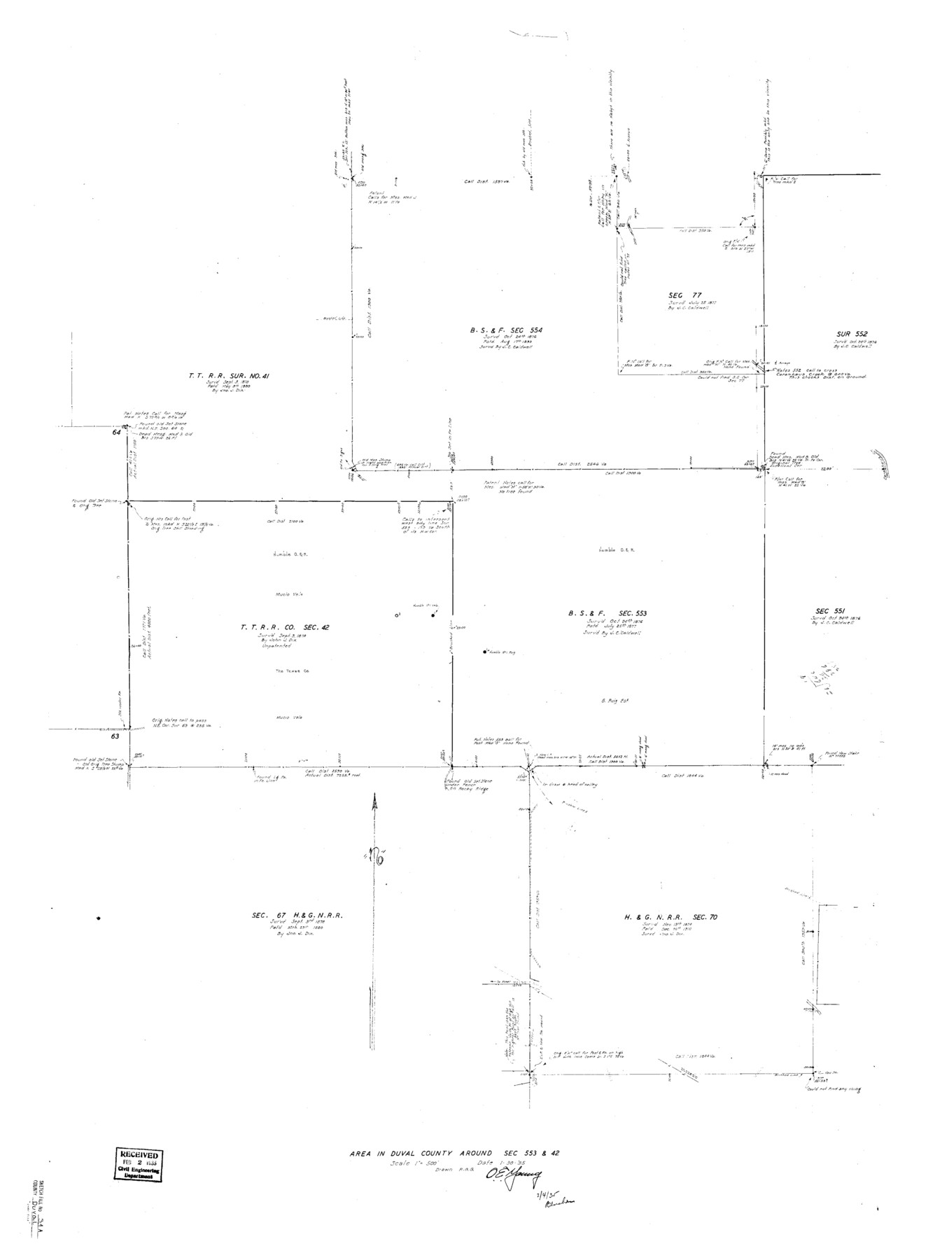
Duval County Sketch File 34a
Area in Duval County Around Sec. 553 & 42
-
Map/Doc
10369
-
Collection
General Map Collection
-
Object Dates
1935/2/4 (File Date)
1876 (Survey Date)
1878 (Survey Date)
1874 (Survey Date)
1935/1/30 (Creation Date)
-
People and Organizations
J.C. Caldwell (Surveyor/Engineer)
John J. Dix (Surveyor/Engineer)
R.G.G. (Draftsman)
O.E. Young (Surveyor/Engineer)
-
Counties
Duval
-
Subjects
Surveying Sketch File
-
Height x Width
45.7 x 34.2 inches
116.1 x 86.9 cm
-
Medium
paper, photocopy
-
Scale
1" = 500 feet
-
Features
Carankaus [sic] Creek
Part of: General Map Collection
Morris County Rolled Sketch 1

Print $20.00
- Digital $50.00
Morris County Rolled Sketch 1
1942
Size 23.7 x 24.9 inches
Map/Doc 6835
Rio Grande, Fernando Sheet

Print $4.00
- Digital $50.00
Rio Grande, Fernando Sheet
1935
Size 20.8 x 25.8 inches
Map/Doc 65114
Reagan County Working Sketch 22

Print $20.00
- Digital $50.00
Reagan County Working Sketch 22
1955
Size 24.2 x 24.4 inches
Map/Doc 71864
Reagan County Rolled Sketch 17

Print $20.00
- Digital $50.00
Reagan County Rolled Sketch 17
Size 34.8 x 32.9 inches
Map/Doc 9812
Map of the survey of the 100th Meridian of longitude west of Greenwich beginning at Red River and extending to the parallel 36 1/2 degrees north latitude

Print $40.00
- Digital $50.00
Map of the survey of the 100th Meridian of longitude west of Greenwich beginning at Red River and extending to the parallel 36 1/2 degrees north latitude
1862
Size 111.9 x 10.4 inches
Map/Doc 3094
Irion County Rolled Sketch 4

Print $20.00
- Digital $50.00
Irion County Rolled Sketch 4
Size 25.6 x 36.4 inches
Map/Doc 6319
Flight Mission No. BRA-3M, Frame 198, Jefferson County

Print $20.00
- Digital $50.00
Flight Mission No. BRA-3M, Frame 198, Jefferson County
1953
Size 18.7 x 22.4 inches
Map/Doc 85413
Chambers County Working Sketch 5
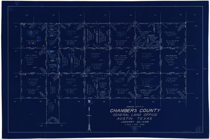
Print $20.00
- Digital $50.00
Chambers County Working Sketch 5
1938
Size 20.9 x 31.6 inches
Map/Doc 67988
Map of Parmer County

Print $20.00
- Digital $50.00
Map of Parmer County
1900
Size 47.8 x 41.3 inches
Map/Doc 16786
Hardeman County Rolled Sketch 24

Print $20.00
- Digital $50.00
Hardeman County Rolled Sketch 24
1959
Size 26.8 x 32.2 inches
Map/Doc 6074
Presidio County Rolled Sketch 1

Print $20.00
- Digital $50.00
Presidio County Rolled Sketch 1
Size 24.5 x 15.7 inches
Map/Doc 7325
Chambers County Sketch File 1

Print $4.00
- Digital $50.00
Chambers County Sketch File 1
1856
Size 7.8 x 12.2 inches
Map/Doc 17516
You may also like
Phelps's National Map of the United States, a Travellers Guide. Embracing the principal railroads, canals, steamboat & stage routes, throughout the Union

Print $20.00
- Digital $50.00
Phelps's National Map of the United States, a Travellers Guide. Embracing the principal railroads, canals, steamboat & stage routes, throughout the Union
1849
Size 20.9 x 26.3 inches
Map/Doc 95901
Presidio County Working Sketch 121a

Print $20.00
- Digital $50.00
Presidio County Working Sketch 121a
Size 34.2 x 38.0 inches
Map/Doc 71798
Upton County Rolled Sketch 27

Print $40.00
- Digital $50.00
Upton County Rolled Sketch 27
1945
Size 42.1 x 62.1 inches
Map/Doc 10046
Flight Mission No. DCL-4C, Frame 146, Kenedy County

Print $20.00
- Digital $50.00
Flight Mission No. DCL-4C, Frame 146, Kenedy County
1943
Size 18.6 x 22.3 inches
Map/Doc 85824

Laneer vs. Bivins, Potter County, Texas

Print $20.00
- Digital $50.00
Laneer vs. Bivins, Potter County, Texas
Size 21.1 x 18.8 inches
Map/Doc 93062
Williamson County Sketch File 12

Print $4.00
- Digital $50.00
Williamson County Sketch File 12
1860
Size 12.6 x 3.4 inches
Map/Doc 40326
Atascosa County Sketch File 3

Print $14.00
- Digital $50.00
Atascosa County Sketch File 3
1854
Size 9.1 x 8.6 inches
Map/Doc 13730
Edwards County Boundary File 29

Print $22.00
- Digital $50.00
Edwards County Boundary File 29
Size 15.4 x 31.0 inches
Map/Doc 65502
Anderson County Working Sketch 37

Print $20.00
- Digital $50.00
Anderson County Working Sketch 37
1984
Size 18.2 x 24.4 inches
Map/Doc 67037
Pecos County Sketch File 95

Print $6.00
- Digital $50.00
Pecos County Sketch File 95
1956
Size 11.2 x 8.8 inches
Map/Doc 33995
[Part of Eastern Texas RR. Co. Block 1]
![91897, [Part of Eastern Texas RR. Co. Block 1], Twichell Survey Records](https://historictexasmaps.com/wmedia_w700/maps/91897-1.tif.jpg)
Print $20.00
- Digital $50.00
[Part of Eastern Texas RR. Co. Block 1]
Size 12.0 x 16.2 inches
Map/Doc 91897