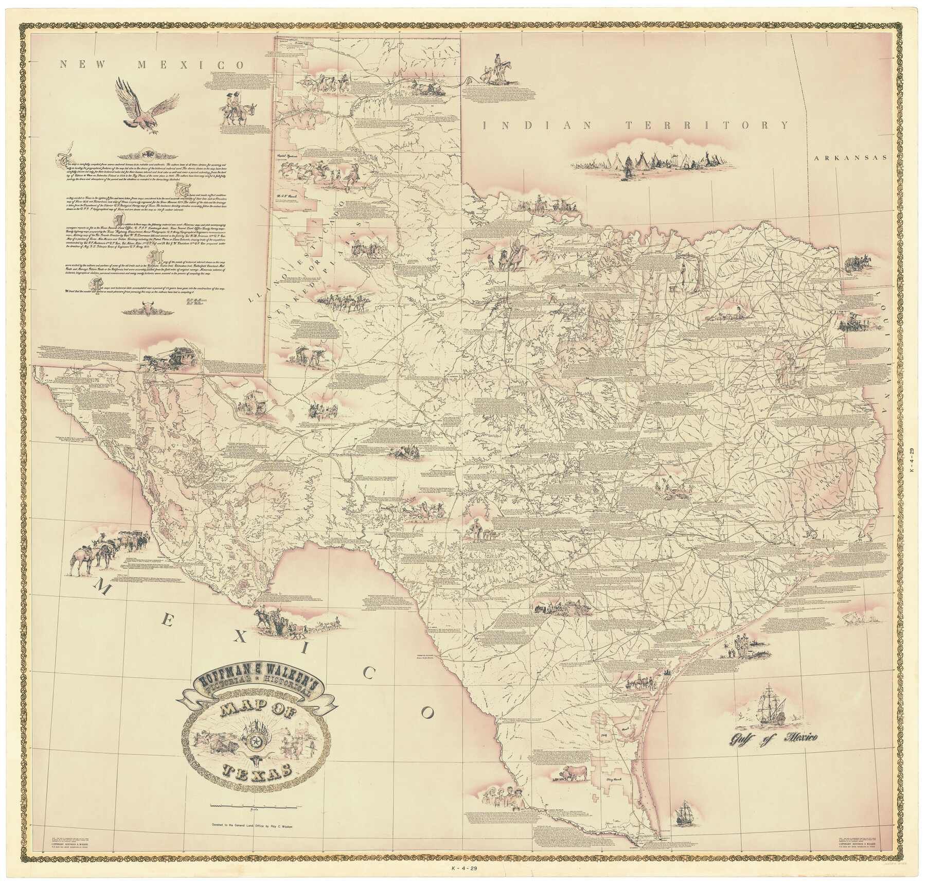
Hoffman and Walker's Pictorial, Historical Map of Texas
K-4-29
-
Map/Doc
2122
-
Collection
General Map Collection
-
Object Dates
1960 - 1969 (Creation Date)
-
People and Organizations
Hoffman and Walker (Author)
-
Subjects
Pictorial State of Texas
-
Height x Width
44.0 x 45.5 inches
111.8 x 115.6 cm
-
Comments
Map presented to Col. George I. Taylor, as a gift in 1966 when he was Chief of Staff of the 1st Armored Division while serving at Ft. Hood, Texas.
Donated to the GLO by his children in his honor.
Pictorial and historical. Available for research only--copyrighted and unavailable for duplication. -
URLs
https://medium.com/save-texas-history/illustrated-cartography-pictorial-maps-at-the-glo-hoffman-and-walkers-historical-pictorial-map-55c31eed7cf2#.el8rqclef
Part of: General Map Collection
Stonewall County Working Sketch 34

Print $20.00
- Digital $50.00
Stonewall County Working Sketch 34
Size 34.0 x 33.9 inches
Map/Doc 62341
Montgomery County Working Sketch 50

Print $20.00
- Digital $50.00
Montgomery County Working Sketch 50
Size 25.3 x 21.9 inches
Map/Doc 71157
Bandera County Working Sketch 5

Print $3.00
- Digital $50.00
Bandera County Working Sketch 5
1915
Size 12.0 x 9.0 inches
Map/Doc 67598
El Paso County Working Sketch 49

Print $20.00
- Digital $50.00
El Paso County Working Sketch 49
Size 36.8 x 23.1 inches
Map/Doc 69071
Map of part of the State of Texas

Print $3.00
- Digital $50.00
Map of part of the State of Texas
1857
Size 8.0 x 9.6 inches
Map/Doc 95363

Map of Austin's Li[ttle Colony Above the] San [Antonio Road]
![215, Map of Austin's Li[ttle Colony Above the] San [Antonio Road], General Map Collection](https://historictexasmaps.com/wmedia_w700/maps/215.tif.jpg)
Print $20.00
- Digital $50.00
Map of Austin's Li[ttle Colony Above the] San [Antonio Road]
1831
Size 14.2 x 19.3 inches
Map/Doc 215
Bastrop County Working Sketch 5

Print $20.00
- Digital $50.00
Bastrop County Working Sketch 5
1923
Size 14.3 x 19.5 inches
Map/Doc 67305
Zavala County Sketch File 12

Print $54.00
- Digital $50.00
Zavala County Sketch File 12
1886
Size 9.0 x 7.7 inches
Map/Doc 41279
Right of Way and Track Map, Texas & New Orleans R.R. Co. operated by the T. & N. O. R.R. Co., Dallas-Sabine Branch

Print $40.00
- Digital $50.00
Right of Way and Track Map, Texas & New Orleans R.R. Co. operated by the T. & N. O. R.R. Co., Dallas-Sabine Branch
1918
Size 24.6 x 56.4 inches
Map/Doc 64631
Controlled Mosaic by Jack Amman Photogrammetric Engineers, Inc - Sheet 46

Print $20.00
- Digital $50.00
Controlled Mosaic by Jack Amman Photogrammetric Engineers, Inc - Sheet 46
1954
Size 20.0 x 24.0 inches
Map/Doc 83505
Matagorda County Sketch File 28

Print $6.00
- Digital $50.00
Matagorda County Sketch File 28
1909
Size 14.2 x 8.8 inches
Map/Doc 30812
You may also like
Navigation Maps of Gulf Intracoastal Waterway, Port Arthur to Brownsville, Texas

Print $4.00
- Digital $50.00
Navigation Maps of Gulf Intracoastal Waterway, Port Arthur to Brownsville, Texas
1951
Size 16.6 x 21.5 inches
Map/Doc 65436
Armstrong County Sketch File A-15

Print $40.00
- Digital $50.00
Armstrong County Sketch File A-15
Size 17.8 x 14.0 inches
Map/Doc 13716
Donley County Working Sketch 9

Print $20.00
- Digital $50.00
Donley County Working Sketch 9
Size 24.7 x 42.2 inches
Map/Doc 68742
Parker County Sketch File 28

Print $6.00
- Digital $50.00
Parker County Sketch File 28
1876
Size 15.7 x 10.2 inches
Map/Doc 33568
General Highway Map, Childress County, Texas

Print $20.00
General Highway Map, Childress County, Texas
1940
Size 18.3 x 25.2 inches
Map/Doc 79046
Cottle County Sketch File 7

Print $20.00
- Digital $50.00
Cottle County Sketch File 7
1893
Size 22.1 x 20.7 inches
Map/Doc 11191
Tom Green County Sketch File 16

Print $16.00
- Digital $50.00
Tom Green County Sketch File 16
Size 8.5 x 7.8 inches
Map/Doc 38174
Cameron County Sketch File 8b

Print $145.00
- Digital $50.00
Cameron County Sketch File 8b
Size 14.0 x 8.5 inches
Map/Doc 17137
Denton County Sketch File 2

Print $3.00
- Digital $50.00
Denton County Sketch File 2
1855
Size 15.4 x 9.8 inches
Map/Doc 20687
Childress County Rolled Sketch 9A
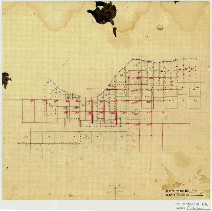
Print $20.00
- Digital $50.00
Childress County Rolled Sketch 9A
Size 17.0 x 17.1 inches
Map/Doc 5447
Sulphur River, Boxelder Sheet/Cuthand Creek

Print $20.00
- Digital $50.00
Sulphur River, Boxelder Sheet/Cuthand Creek
1922
Size 29.5 x 25.1 inches
Map/Doc 65156
Montgomery County Working Sketch 40

Print $20.00
- Digital $50.00
Montgomery County Working Sketch 40
Size 18.1 x 23.3 inches
Map/Doc 71147