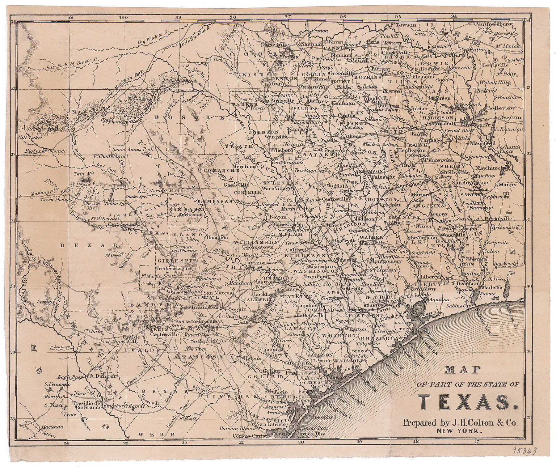
Map of part of the State of Texas
-
Map/Doc
95363
-
Collection
General Map Collection
-
Object Dates
1857 (Creation Date)
-
People and Organizations
J.H. Colton & Co. (Publisher)
-
Subjects
State of Texas
-
Height x Width
8.0 x 9.6 inches
20.3 x 24.4 cm
-
Medium
paper, etching/engraving/lithograph
Part of: General Map Collection
Map of Brazoria County

Print $20.00
- Digital $50.00
Map of Brazoria County
1883
Size 26.8 x 25.6 inches
Map/Doc 861
Terry County Boundary File 5

Print $2.00
- Digital $50.00
Terry County Boundary File 5
Size 14.2 x 8.9 inches
Map/Doc 59257
Gregg County Rolled Sketch 9

Print $20.00
- Digital $50.00
Gregg County Rolled Sketch 9
1933
Size 38.0 x 29.8 inches
Map/Doc 6034
Coke County Sketch File 25

Print $34.00
- Digital $50.00
Coke County Sketch File 25
1930
Size 14.2 x 8.9 inches
Map/Doc 18618
Ward County Rolled Sketch 3

Print $40.00
- Digital $50.00
Ward County Rolled Sketch 3
Size 65.3 x 25.7 inches
Map/Doc 10101
Leon County Working Sketch 43

Print $40.00
- Digital $50.00
Leon County Working Sketch 43
1980
Size 55.1 x 38.0 inches
Map/Doc 70442
Nolan County Working Sketch 4

Print $20.00
- Digital $50.00
Nolan County Working Sketch 4
1948
Size 21.6 x 28.9 inches
Map/Doc 71295
Bastrop County Sketch File 4

Print $4.00
- Digital $50.00
Bastrop County Sketch File 4
1873
Size 12.7 x 7.9 inches
Map/Doc 14046
Potter County Boundary File 4

Print $30.00
- Digital $50.00
Potter County Boundary File 4
Size 14.6 x 9.3 inches
Map/Doc 57997
[Coastal Chart of Galveston Island, Bolivar Peninsula and Galveston Bay]
![61804, [Coastal Chart of Galveston Island, Bolivar Peninsula and Galveston Bay], General Map Collection](https://historictexasmaps.com/wmedia_w700/maps/61804.tif.jpg)
Print $20.00
- Digital $50.00
[Coastal Chart of Galveston Island, Bolivar Peninsula and Galveston Bay]
Size 24.0 x 18.1 inches
Map/Doc 61804
Fort Bend County Working Sketch 3

Print $20.00
- Digital $50.00
Fort Bend County Working Sketch 3
1897
Size 26.8 x 24.6 inches
Map/Doc 69209
[Sketch for Mineral Application 24072, San Jacinto River]
![65608, [Sketch for Mineral Application 24072, San Jacinto River], General Map Collection](https://historictexasmaps.com/wmedia_w700/maps/65608.tif.jpg)
Print $20.00
- Digital $50.00
[Sketch for Mineral Application 24072, San Jacinto River]
1929
Size 8.6 x 14.0 inches
Map/Doc 65608
You may also like
Flight Mission No. BQR-13K, Frame 25, Brazoria County

Print $20.00
- Digital $50.00
Flight Mission No. BQR-13K, Frame 25, Brazoria County
1952
Size 18.8 x 22.4 inches
Map/Doc 84073

General Highway Map, Atascosa County, Texas

Print $20.00
General Highway Map, Atascosa County, Texas
1940
Size 18.5 x 25.0 inches
Map/Doc 79007
Austin County Boundary File 2

Print $32.00
- Digital $50.00
Austin County Boundary File 2
Size 22.4 x 30.7 inches
Map/Doc 50236
Presidio County Working Sketch 114

Print $40.00
- Digital $50.00
Presidio County Working Sketch 114
1981
Size 63.9 x 37.9 inches
Map/Doc 71791
[H. & G. N. Block 1]
![90942, [H. & G. N. Block 1], Twichell Survey Records](https://historictexasmaps.com/wmedia_w700/maps/90942-1.tif.jpg)
Print $20.00
- Digital $50.00
[H. & G. N. Block 1]
1873
Size 14.3 x 17.6 inches
Map/Doc 90942
Flight Mission No. CRC-4R, Frame 78, Chambers County

Print $20.00
- Digital $50.00
Flight Mission No. CRC-4R, Frame 78, Chambers County
1956
Size 18.7 x 22.5 inches
Map/Doc 84882
Trinity County Sketch File 36

Print $20.00
- Digital $50.00
Trinity County Sketch File 36
Size 43.4 x 18.1 inches
Map/Doc 10408
Aransas County Sketch File 25

Print $20.00
- Digital $50.00
Aransas County Sketch File 25
Size 17.0 x 17.5 inches
Map/Doc 13218
Reagan County Rolled Sketch 17

Print $20.00
- Digital $50.00
Reagan County Rolled Sketch 17
Size 34.8 x 32.9 inches
Map/Doc 9812
Duval County Sketch File 35b

Print $6.00
- Digital $50.00
Duval County Sketch File 35b
1935
Size 14.4 x 8.8 inches
Map/Doc 21374
Map of Hopkins County

Print $20.00
- Digital $50.00
Map of Hopkins County
1872
Size 16.3 x 18.1 inches
Map/Doc 3678