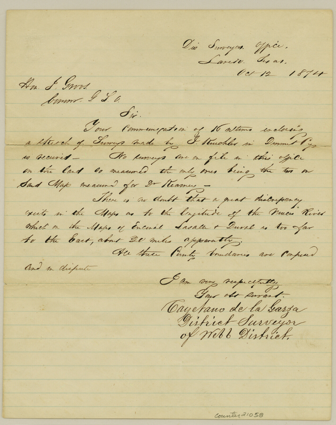
Dimmit County Sketch File 3
[Explanation regarding surveys in southeast corner of county and field notes of connecting line]
-
Map/Doc
21058
-
Collection
General Map Collection
-
Object Dates
1874/10/12 (Creation Date)
1874/10/26 (File Date)
-
People and Organizations
Cayetano de la Garza (Surveyor/Engineer)
Jacob Kuechler (Surveyor/Engineer)
-
Counties
Dimmit La Salle
-
Subjects
Surveying Sketch File
-
Height x Width
10.1 x 8.0 inches
25.7 x 20.3 cm
-
Medium
multi-page, multi-format
Part of: General Map Collection
Map accompanying report of scout made by 2nd Lt. F. de I. Carrington. 1st Infantry

Print $20.00
- Digital $50.00
Map accompanying report of scout made by 2nd Lt. F. de I. Carrington. 1st Infantry
1881
Size 22.2 x 18.0 inches
Map/Doc 65407
University Lands Blocks 1-13 & Block 58, Crockett, Reagan & Upton Counties

Print $20.00
- Digital $50.00
University Lands Blocks 1-13 & Block 58, Crockett, Reagan & Upton Counties
1936
Size 37.3 x 42.0 inches
Map/Doc 2445
Pecos County Rolled Sketch 178

Print $20.00
- Digital $50.00
Pecos County Rolled Sketch 178
1979
Size 38.5 x 28.7 inches
Map/Doc 7298
Flight Mission No. CLL-1N, Frame 10, Willacy County

Print $20.00
- Digital $50.00
Flight Mission No. CLL-1N, Frame 10, Willacy County
1954
Size 18.5 x 22.1 inches
Map/Doc 86997
Flight Mission No. BRE-2P, Frame 67, Nueces County

Print $20.00
- Digital $50.00
Flight Mission No. BRE-2P, Frame 67, Nueces County
1956
Size 18.5 x 22.3 inches
Map/Doc 86762
Aransas County Rolled Sketch 2

Print $40.00
- Digital $50.00
Aransas County Rolled Sketch 2
Size 42.9 x 48.2 inches
Map/Doc 73614
Flight Mission No. CRC-1R, Frame 97, Chambers County

Print $20.00
- Digital $50.00
Flight Mission No. CRC-1R, Frame 97, Chambers County
1956
Size 18.7 x 22.5 inches
Map/Doc 84712
McCulloch County Sketch File 12

Print $6.00
- Digital $50.00
McCulloch County Sketch File 12
1989
Size 14.2 x 8.6 inches
Map/Doc 31198
[Aransas National Wildlife Refuge]
![3119, [Aransas National Wildlife Refuge], General Map Collection](https://historictexasmaps.com/wmedia_w700/maps/3119-1.tif.jpg)
Print $40.00
- Digital $50.00
[Aransas National Wildlife Refuge]
1952
Size 55.9 x 43.4 inches
Map/Doc 3119
Chambers County NRC Article 33.136 Location Key Sheet

Print $20.00
- Digital $50.00
Chambers County NRC Article 33.136 Location Key Sheet
1983
Size 24.0 x 44.0 inches
Map/Doc 77014
Fannin County Sketch File 15

Print $6.00
- Digital $50.00
Fannin County Sketch File 15
1866
Size 8.2 x 8.2 inches
Map/Doc 22466
Mills County Sketch File 28

Print $8.00
- Digital $50.00
Mills County Sketch File 28
2000
Size 14.3 x 8.7 inches
Map/Doc 31684
You may also like
General Highway Map, Gregg County, Texas

Print $20.00
General Highway Map, Gregg County, Texas
1961
Size 18.1 x 24.7 inches
Map/Doc 79488
Andrews County Working Sketch 33

Print $20.00
- Digital $50.00
Andrews County Working Sketch 33
1990
Size 32.9 x 29.7 inches
Map/Doc 67079
Flight Mission No. DIX-7P, Frame 89, Aransas County

Print $20.00
- Digital $50.00
Flight Mission No. DIX-7P, Frame 89, Aransas County
1956
Size 18.7 x 22.4 inches
Map/Doc 83883
[Sketch of San Antonio del Encinal, Hidalgo County, Texas]
![4457, [Sketch of San Antonio del Encinal, Hidalgo County, Texas], Maddox Collection](https://historictexasmaps.com/wmedia_w700/maps/4457-1.tif.jpg)
Print $20.00
- Digital $50.00
[Sketch of San Antonio del Encinal, Hidalgo County, Texas]
Size 12.1 x 27.1 inches
Map/Doc 4457
Callahan County Rolled Sketch 25

Print $20.00
- Digital $50.00
Callahan County Rolled Sketch 25
1974
Size 18.4 x 22.5 inches
Map/Doc 5383
Archer County Sketch File 19

Print $40.00
- Digital $50.00
Archer County Sketch File 19
1902
Size 23.8 x 26.8 inches
Map/Doc 10829
Map of Texas compiled from surveys at the Land Office of Texas

Print $20.00
Map of Texas compiled from surveys at the Land Office of Texas
1851
Size 27.2 x 19.5 inches
Map/Doc 79748
Aransas County Working Sketch 11

Print $20.00
- Digital $50.00
Aransas County Working Sketch 11
1949
Size 17.3 x 18.7 inches
Map/Doc 67178
PSL Field Notes for Blocks C36 and C37 in Gaines and Terry Counties, Block C38 in Dawson, Gaines, and Terry Counties, Blocks C39 and C41 in Dawson and Terry Counties, Block K in Yoakum and Terry Counties

PSL Field Notes for Blocks C36 and C37 in Gaines and Terry Counties, Block C38 in Dawson, Gaines, and Terry Counties, Blocks C39 and C41 in Dawson and Terry Counties, Block K in Yoakum and Terry Counties
Map/Doc 81674
Sabine and Neches Rivers

Print $20.00
- Digital $50.00
Sabine and Neches Rivers
1971
Size 19.7 x 44.4 inches
Map/Doc 69817
Coryell County Sketch File 16

Print $4.00
- Digital $50.00
Coryell County Sketch File 16
Size 6.5 x 5.4 inches
Map/Doc 19373
Bell County Rolled Sketch 1

Print $20.00
- Digital $50.00
Bell County Rolled Sketch 1
1954
Size 38.1 x 41.1 inches
Map/Doc 75938