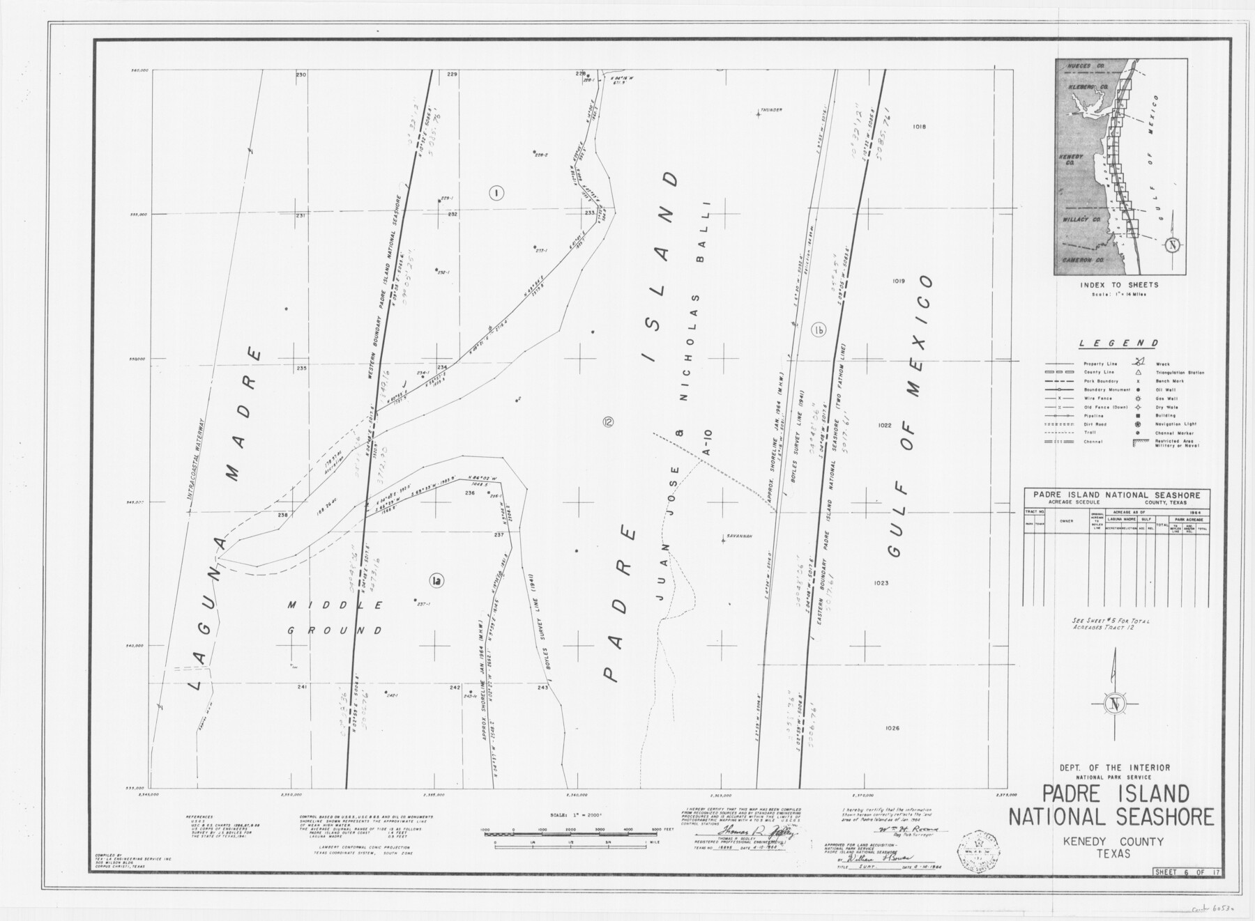
Padre Island National Seashore
17 survey plats of Padre Island National Seashore
N-2-125
-
Map/Doc
60530
-
Collection
General Map Collection
-
Counties
Kenedy
-
Height x Width
16.2 x 22.1 inches
41.1 x 56.1 cm
Part of: General Map Collection
Presidio County Rolled Sketch T-5

Print $20.00
- Digital $50.00
Presidio County Rolled Sketch T-5
1917
Size 21.2 x 20.4 inches
Map/Doc 7419
Upshur County Working Sketch Graphic Index

Print $20.00
- Digital $50.00
Upshur County Working Sketch Graphic Index
1945
Size 40.8 x 35.4 inches
Map/Doc 76720
Bell County Working Sketch 6

Print $20.00
- Digital $50.00
Bell County Working Sketch 6
1946
Size 24.9 x 33.6 inches
Map/Doc 67346
Neches River, Watershed of the Neches River

Print $6.00
- Digital $50.00
Neches River, Watershed of the Neches River
1925
Size 34.6 x 28.3 inches
Map/Doc 65085
Reagan County Rolled Sketch 8

Print $20.00
- Digital $50.00
Reagan County Rolled Sketch 8
Size 30.2 x 26.7 inches
Map/Doc 7436
Galveston County NRC Article 33.136 Sketch 55

Print $78.00
- Digital $50.00
Galveston County NRC Article 33.136 Sketch 55
2009
Size 23.0 x 34.3 inches
Map/Doc 94580
McMullen County Working Sketch 29

Print $40.00
- Digital $50.00
McMullen County Working Sketch 29
1956
Size 59.0 x 37.2 inches
Map/Doc 70730
Eastland County Working Sketch 55

Print $20.00
- Digital $50.00
Eastland County Working Sketch 55
1984
Size 33.5 x 37.8 inches
Map/Doc 68836
Flight Mission No. DAG-21K, Frame 97, Matagorda County

Print $20.00
- Digital $50.00
Flight Mission No. DAG-21K, Frame 97, Matagorda County
1952
Size 18.4 x 22.2 inches
Map/Doc 86426
Young County Working Sketch 27

Print $20.00
- Digital $50.00
Young County Working Sketch 27
1982
Size 24.3 x 32.6 inches
Map/Doc 62050
Westliches - Nordamerica

Print $20.00
- Digital $50.00
Westliches - Nordamerica
1867
Size 25.3 x 20.7 inches
Map/Doc 93753
[Fractional Township No. 7 South Range No. 17 East of the Indian Meridian, Indian Territory]
![75231, [Fractional Township No. 7 South Range No. 17 East of the Indian Meridian, Indian Territory], General Map Collection](https://historictexasmaps.com/wmedia_w700/maps/75231.tif.jpg)
Print $20.00
- Digital $50.00
[Fractional Township No. 7 South Range No. 17 East of the Indian Meridian, Indian Territory]
Size 19.2 x 24.3 inches
Map/Doc 75231
You may also like
Smith County Rolled Sketch 6A1

Print $40.00
- Digital $50.00
Smith County Rolled Sketch 6A1
Size 49.2 x 38.6 inches
Map/Doc 10704
Bell County Sketch File 21

Print $4.00
- Digital $50.00
Bell County Sketch File 21
1871
Size 8.0 x 9.7 inches
Map/Doc 14410
Presidio County Texas

Print $20.00
- Digital $50.00
Presidio County Texas
Size 22.6 x 17.8 inches
Map/Doc 3967
Flight Mission No. BQY-4M, Frame 53, Harris County

Print $20.00
- Digital $50.00
Flight Mission No. BQY-4M, Frame 53, Harris County
1953
Size 18.6 x 22.3 inches
Map/Doc 85262
Collingsworth County Working Sketch 2

Print $20.00
- Digital $50.00
Collingsworth County Working Sketch 2
1957
Size 42.5 x 20.1 inches
Map/Doc 63761

Marion County Sketch File 12

Print $20.00
- Digital $50.00
Marion County Sketch File 12
1912
Size 25.1 x 14.2 inches
Map/Doc 12022
Travis County Working Sketch 16

Print $20.00
- Digital $50.00
Travis County Working Sketch 16
1941
Size 17.8 x 20.5 inches
Map/Doc 69400
Val Verde County Working Sketch 64

Print $20.00
- Digital $50.00
Val Verde County Working Sketch 64
1959
Size 19.0 x 43.0 inches
Map/Doc 72199
Hardin County Sketch File AB

Print $4.00
- Digital $50.00
Hardin County Sketch File AB
Size 13.5 x 7.3 inches
Map/Doc 25071
[Map of San Antonio, Texas]
![93399, [Map of San Antonio, Texas], General Map Collection - 1](https://historictexasmaps.com/wmedia_w700/maps/93399.tif.jpg)
Print $20.00
- Digital $50.00
[Map of San Antonio, Texas]
1895
Size 29.4 x 34.5 inches
Map/Doc 93399
Val Verde County Rolled Sketch 2

Print $40.00
- Digital $50.00
Val Verde County Rolled Sketch 2
Size 49.3 x 28.5 inches
Map/Doc 10069