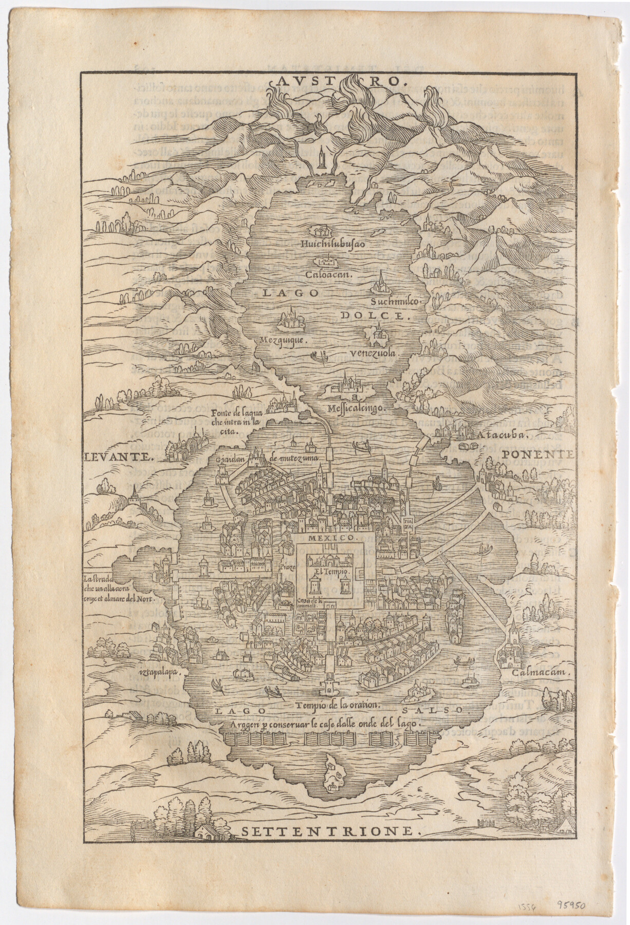
Temistitan
[Mexico City], [Tenochtitlan]
-
Map/Doc
95950
-
Collection
General Map Collection
-
Object Dates
[1556] (Creation Date)
-
People and Organizations
Giovanni Battista Rasmusio (Cartographer)
-
Subjects
City Mexico
-
Height x Width
12.9 x 8.8 inches
32.8 x 22.4 cm
-
Medium
paper, etching/engraving/lithograph
-
Comments
From Rasmusio's atlas, "Navigatione et Viaggi". To view text on verso, click "Download PDF" link above.
Part of: General Map Collection
Flight Mission No. CRC-3R, Frame 14, Chambers County

Print $20.00
- Digital $50.00
Flight Mission No. CRC-3R, Frame 14, Chambers County
1956
Size 18.6 x 22.3 inches
Map/Doc 84788
Tyler County Sketch File 23

Print $20.00
- Digital $50.00
Tyler County Sketch File 23
Size 25.3 x 20.9 inches
Map/Doc 12500
Gillespie County Boundary File 6

Print $2.00
- Digital $50.00
Gillespie County Boundary File 6
Size 11.3 x 8.9 inches
Map/Doc 53770
Freestone County Boundary File 30d

Print $20.00
- Digital $50.00
Freestone County Boundary File 30d
Size 8.0 x 29.6 inches
Map/Doc 53608
Mason County Sketch File 21A

Print $20.00
- Digital $50.00
Mason County Sketch File 21A
1932
Size 19.2 x 26.6 inches
Map/Doc 12037
Sutton County Working Sketch 10

Print $40.00
- Digital $50.00
Sutton County Working Sketch 10
1972
Size 71.0 x 42.9 inches
Map/Doc 62353
Potter County Boundary File 3f

Print $4.00
- Digital $50.00
Potter County Boundary File 3f
Size 6.3 x 4.4 inches
Map/Doc 57995
Floyd County Rolled Sketch 11

Print $20.00
- Digital $50.00
Floyd County Rolled Sketch 11
2000
Size 15.5 x 20.9 inches
Map/Doc 5884
Shackelford County Rolled Sketch 7

Print $20.00
- Digital $50.00
Shackelford County Rolled Sketch 7
2009
Size 36.9 x 24.8 inches
Map/Doc 89229
Harris County

Print $20.00
- Digital $50.00
Harris County
1940
Size 37.7 x 46.4 inches
Map/Doc 95522
Coke County Working Sketch 5

Print $20.00
- Digital $50.00
Coke County Working Sketch 5
1913
Size 24.1 x 27.9 inches
Map/Doc 68042
[Map of the Houston and G. N. R.R. and lands adjacent, from Troupe to the Texas Pacific R.R.]
![64628, [Map of the Houston and G. N. R.R. and lands adjacent, from Troupe to the Texas Pacific R.R.], General Map Collection](https://historictexasmaps.com/wmedia_w700/maps/64628.tif.jpg)
Print $40.00
- Digital $50.00
[Map of the Houston and G. N. R.R. and lands adjacent, from Troupe to the Texas Pacific R.R.]
1873
Size 20.2 x 49.3 inches
Map/Doc 64628
You may also like
[Galveston, Harrisburg & San Antonio through El Paso County]
![64001, [Galveston, Harrisburg & San Antonio through El Paso County], General Map Collection](https://historictexasmaps.com/wmedia_w700/maps/64001.tif.jpg)
Print $20.00
- Digital $50.00
[Galveston, Harrisburg & San Antonio through El Paso County]
1907
Size 13.6 x 33.7 inches
Map/Doc 64001
Newton County Working Sketch 5

Print $20.00
- Digital $50.00
Newton County Working Sketch 5
1926
Size 16.0 x 20.0 inches
Map/Doc 71251
[Sketch for Mineral Application 19443 - Brazos River]
![65683, [Sketch for Mineral Application 19443 - Brazos River], General Map Collection](https://historictexasmaps.com/wmedia_w700/maps/65683.tif.jpg)
Print $40.00
- Digital $50.00
[Sketch for Mineral Application 19443 - Brazos River]
1853
Size 117.1 x 30.5 inches
Map/Doc 65683
Hansford County Sketch File 1

Print $7.00
- Digital $50.00
Hansford County Sketch File 1
1888
Size 39.0 x 31.3 inches
Map/Doc 10475
Aransas County

Print $20.00
- Digital $50.00
Aransas County
1871
Size 17.2 x 18.3 inches
Map/Doc 3235
Gray County, Texas

Print $20.00
- Digital $50.00
Gray County, Texas
1889
Size 23.7 x 17.4 inches
Map/Doc 630
The Chief Justice County of Bexar. May 1, 1837

Print $20.00
The Chief Justice County of Bexar. May 1, 1837
2020
Size 25.4 x 21.6 inches
Map/Doc 96038
Hemphill County Texas

Print $20.00
- Digital $50.00
Hemphill County Texas
Size 21.9 x 24.6 inches
Map/Doc 92183
Map of Public Land on Mustang Island

Print $20.00
- Digital $50.00
Map of Public Land on Mustang Island
1907
Size 17.7 x 22.3 inches
Map/Doc 91492
McMullen County Rolled Sketch 19

Print $20.00
- Digital $50.00
McMullen County Rolled Sketch 19
1963
Size 26.6 x 39.6 inches
Map/Doc 6735
Baylor County Sketch File A3

Print $14.00
- Digital $50.00
Baylor County Sketch File A3
1899
Size 11.4 x 8.7 inches
Map/Doc 14077
Eastland County Sketch File 1

Print $8.00
- Digital $50.00
Eastland County Sketch File 1
Size 9.0 x 7.9 inches
Map/Doc 21555