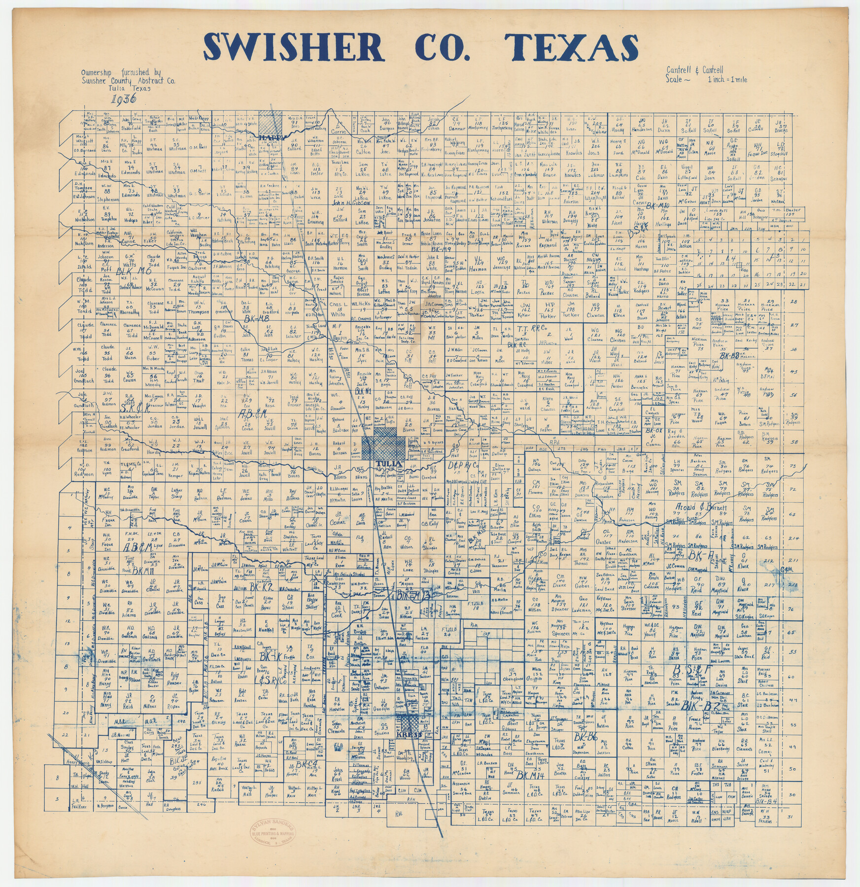
Swisher Co. Texas
-
Map/Doc
89876
-
Collection
Twichell Survey Records
-
Object Dates
1936 (Creation Date)
-
People and Organizations
Swisher County Abstract Co. (Compiler)
Cantrell & Cantrell (Draftsman)
-
Counties
Swisher
-
Subjects
County
-
Height x Width
36.8 x 38.0 inches
93.5 x 96.5 cm
Part of: Twichell Survey Records
[East Neches River]
![90420, [East Neches River], Twichell Survey Records](https://historictexasmaps.com/wmedia_w700/maps/90420-1.tif.jpg)
Print $20.00
- Digital $50.00
[East Neches River]
Size 25.8 x 29.3 inches
Map/Doc 90420
[Part of Block GG and river sections 69-79]
![90470, [Part of Block GG and river sections 69-79], Twichell Survey Records](https://historictexasmaps.com/wmedia_w700/maps/90470-1.tif.jpg)
Print $20.00
- Digital $50.00
[Part of Block GG and river sections 69-79]
Size 43.2 x 31.2 inches
Map/Doc 90470
Blocks 3 and 4 Capitol Syndicate Subdivision of Capitol Leagues

Print $20.00
- Digital $50.00
Blocks 3 and 4 Capitol Syndicate Subdivision of Capitol Leagues
1906
Size 17.5 x 27.4 inches
Map/Doc 90581
[Blocks 44 and 6T and vicinity]
![91490, [Blocks 44 and 6T and vicinity], Twichell Survey Records](https://historictexasmaps.com/wmedia_w700/maps/91490-1.tif.jpg)
Print $20.00
- Digital $50.00
[Blocks 44 and 6T and vicinity]
Size 29.4 x 17.4 inches
Map/Doc 91490
[Adams Beaty & Moulton Block 2] / Map of Heller's Addition to Canyon City
![92120, [Adams Beaty & Moulton Block 2] / Map of Heller's Addition to Canyon City, Twichell Survey Records](https://historictexasmaps.com/wmedia_w700/maps/92120-1.tif.jpg)
Print $20.00
- Digital $50.00
[Adams Beaty & Moulton Block 2] / Map of Heller's Addition to Canyon City
1898
Size 22.7 x 24.9 inches
Map/Doc 92120
[Block K5, Section 13]
![91451, [Block K5, Section 13], Twichell Survey Records](https://historictexasmaps.com/wmedia_w700/maps/91451-1.tif.jpg)
Print $3.00
- Digital $50.00
[Block K5, Section 13]
Size 11.4 x 10.4 inches
Map/Doc 91451
[H. & T. C. 46, Sections 79- 84]
![91262, [H. & T. C. 46, Sections 79- 84], Twichell Survey Records](https://historictexasmaps.com/wmedia_w700/maps/91262-1.tif.jpg)
Print $20.00
- Digital $50.00
[H. & T. C. 46, Sections 79- 84]
Size 27.3 x 32.6 inches
Map/Doc 91262
[Northwest Portion of King County]
![90978, [Northwest Portion of King County], Twichell Survey Records](https://historictexasmaps.com/wmedia_w700/maps/90978-1.tif.jpg)
Print $20.00
- Digital $50.00
[Northwest Portion of King County]
Size 28.7 x 35.7 inches
Map/Doc 90978
[Sketch of Runnels County School Land and vicinity]
![91666, [Sketch of Runnels County School Land and vicinity], Twichell Survey Records](https://historictexasmaps.com/wmedia_w700/maps/91666-1.tif.jpg)
Print $20.00
- Digital $50.00
[Sketch of Runnels County School Land and vicinity]
Size 17.3 x 15.3 inches
Map/Doc 91666
Map of Sections 1-60 Block 46, H. & T. C. RR. Co. Survey according to courses and distances - Maddox survey

Print $40.00
- Digital $50.00
Map of Sections 1-60 Block 46, H. & T. C. RR. Co. Survey according to courses and distances - Maddox survey
Size 75.6 x 20.2 inches
Map/Doc 93129
Right-of-way & Track Map Dawson Railway Operated by the El Paso & Southwestern Company Station 1867+09.6 to Station 360+75.4

Print $40.00
- Digital $50.00
Right-of-way & Track Map Dawson Railway Operated by the El Paso & Southwestern Company Station 1867+09.6 to Station 360+75.4
1910
Size 56.9 x 24.7 inches
Map/Doc 89659
[Block 6T, Portions of Blocks 44, 2T, and 3T, and vicinity]
![91526, [Block 6T, Portions of Blocks 44, 2T, and 3T, and vicinity], Twichell Survey Records](https://historictexasmaps.com/wmedia_w700/maps/91526-1.tif.jpg)
Print $20.00
- Digital $50.00
[Block 6T, Portions of Blocks 44, 2T, and 3T, and vicinity]
Size 14.2 x 15.9 inches
Map/Doc 91526
You may also like
Briscoe County

Print $20.00
- Digital $50.00
Briscoe County
1930
Size 46.2 x 39.2 inches
Map/Doc 1787
Crane County State of Texas

Print $20.00
- Digital $50.00
Crane County State of Texas
1889
Size 22.9 x 17.6 inches
Map/Doc 4524
Working Sketch in Eastland, Stephens, and Palo Pinto Cos.

Print $20.00
- Digital $50.00
Working Sketch in Eastland, Stephens, and Palo Pinto Cos.
Size 18.0 x 15.1 inches
Map/Doc 91975
Township 10 South Range 13 West, South Western District, Louisiana

Print $20.00
- Digital $50.00
Township 10 South Range 13 West, South Western District, Louisiana
1876
Size 19.5 x 24.6 inches
Map/Doc 65853
Dimmit County Working Sketch 26

Print $20.00
- Digital $50.00
Dimmit County Working Sketch 26
1956
Size 19.3 x 15.9 inches
Map/Doc 68687
Trinity County Rolled Sketch 4

Print $20.00
- Digital $50.00
Trinity County Rolled Sketch 4
1948
Size 38.5 x 42.4 inches
Map/Doc 10026
Coke County Sketch File 9

Print $4.00
- Digital $50.00
Coke County Sketch File 9
Size 12.6 x 7.9 inches
Map/Doc 18585
Live Oak County Boundary File 60c

Print $4.00
- Digital $50.00
Live Oak County Boundary File 60c
Size 14.0 x 8.7 inches
Map/Doc 56421
Anderson County Working Sketch 23

Print $20.00
- Digital $50.00
Anderson County Working Sketch 23
1958
Size 23.1 x 24.8 inches
Map/Doc 67023
Hardin County Rolled Sketch MH

Print $21.00
- Digital $50.00
Hardin County Rolled Sketch MH
1936
Size 10.1 x 15.2 inches
Map/Doc 45760
Travis County Boundary File 6

Print $109.00
- Digital $50.00
Travis County Boundary File 6
Size 14.6 x 9.1 inches
Map/Doc 59433
Atascosa County Working Sketch 21

Print $20.00
- Digital $50.00
Atascosa County Working Sketch 21
1954
Size 26.0 x 22.4 inches
Map/Doc 67217