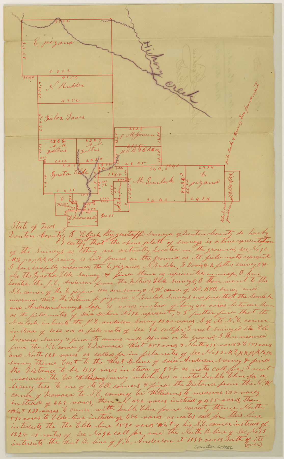
Denton County Sketch File 28
[Sketch of surveys south of Hickory Creek]
-
Map/Doc
20756
-
Collection
General Map Collection
-
Object Dates
1881/7/18 (File Date)
-
People and Organizations
Elijah Biggerstaff (Surveyor/Engineer)
-
Counties
Denton
-
Subjects
Surveying Sketch File
-
Height x Width
14.4 x 8.9 inches
36.6 x 22.6 cm
-
Medium
paper, manuscript
-
Features
Hickory Creek
Part of: General Map Collection
Reagan County Sketch File 11

Print $20.00
- Digital $50.00
Reagan County Sketch File 11
1928
Size 26.7 x 22.2 inches
Map/Doc 12217
Flight Mission No. BQR-5K, Frame 65, Brazoria County

Print $20.00
- Digital $50.00
Flight Mission No. BQR-5K, Frame 65, Brazoria County
1952
Size 18.8 x 22.5 inches
Map/Doc 84010
[Maps of surveys in Reeves & Culberson Cos]
![61139, [Maps of surveys in Reeves & Culberson Cos], General Map Collection](https://historictexasmaps.com/wmedia_w700/maps/61139.tif.jpg)
Print $20.00
- Digital $50.00
[Maps of surveys in Reeves & Culberson Cos]
1937
Size 30.7 x 24.7 inches
Map/Doc 61139
Trinity River, Reagor Springs Sheet/Waxahachie Creek

Print $4.00
- Digital $50.00
Trinity River, Reagor Springs Sheet/Waxahachie Creek
1931
Size 29.9 x 25.6 inches
Map/Doc 65236
Wilbarger County Working Sketch 8

Print $20.00
- Digital $50.00
Wilbarger County Working Sketch 8
1948
Size 31.8 x 38.2 inches
Map/Doc 72546
Map of Texas and part of New Mexico compiled in the Bureau of Topographl. Engrs. chiefly for military purposes

Print $20.00
- Digital $50.00
Map of Texas and part of New Mexico compiled in the Bureau of Topographl. Engrs. chiefly for military purposes
1857
Size 18.8 x 24.8 inches
Map/Doc 97116
Baylor County Working Sketch 4

Print $20.00
- Digital $50.00
Baylor County Working Sketch 4
1938
Size 30.4 x 21.0 inches
Map/Doc 67289
Flight Mission No. DCL-6C, Frame 179, Kenedy County

Print $20.00
- Digital $50.00
Flight Mission No. DCL-6C, Frame 179, Kenedy County
1943
Size 18.6 x 22.4 inches
Map/Doc 85991
Index to the following sixteen sheets, being a compleat chart of the West Indies with letters in the margin to direct the placing of the different sheets in their proper places

Print $20.00
- Digital $50.00
Index to the following sixteen sheets, being a compleat chart of the West Indies with letters in the margin to direct the placing of the different sheets in their proper places
1792
Size 21.5 x 28.6 inches
Map/Doc 96440
Hamilton County Working Sketch 9

Print $20.00
- Digital $50.00
Hamilton County Working Sketch 9
1946
Size 31.3 x 24.0 inches
Map/Doc 63347
[Cotton Belt, St. Louis Southwestern Railway of Texas, Alignment through Smith County]
![64377, [Cotton Belt, St. Louis Southwestern Railway of Texas, Alignment through Smith County], General Map Collection](https://historictexasmaps.com/wmedia_w700/maps/64377.tif.jpg)
Print $20.00
- Digital $50.00
[Cotton Belt, St. Louis Southwestern Railway of Texas, Alignment through Smith County]
1903
Size 21.7 x 30.0 inches
Map/Doc 64377
Hunt County Working Sketch 7

Print $20.00
- Digital $50.00
Hunt County Working Sketch 7
1955
Size 43.2 x 25.2 inches
Map/Doc 66354
You may also like
Harris County Rolled Sketch 93

Print $20.00
- Digital $50.00
Harris County Rolled Sketch 93
1983
Size 45.0 x 40.2 inches
Map/Doc 9142
Kaufman County Boundary File 6

Print $14.00
- Digital $50.00
Kaufman County Boundary File 6
Size 11.2 x 8.7 inches
Map/Doc 55956
Station Map, the Missouri, Kansas and Texas Ry. Of Texas - Henrietta Division

Print $20.00
- Digital $50.00
Station Map, the Missouri, Kansas and Texas Ry. Of Texas - Henrietta Division
1918
Size 11.7 x 26.8 inches
Map/Doc 64764
Flight Mission No. DAG-21K, Frame 94, Matagorda County

Print $20.00
- Digital $50.00
Flight Mission No. DAG-21K, Frame 94, Matagorda County
1952
Size 18.6 x 22.3 inches
Map/Doc 86423
Flight Mission No. DAH-17M, Frame 67, Orange County

Print $20.00
- Digital $50.00
Flight Mission No. DAH-17M, Frame 67, Orange County
1953
Size 18.5 x 22.3 inches
Map/Doc 86901
Dawson County Rolled Sketch 12

Print $20.00
- Digital $50.00
Dawson County Rolled Sketch 12
1965
Size 15.6 x 33.2 inches
Map/Doc 5695
Galveston County NRC Article 33.136 Sketch 85

Print $42.00
- Digital $50.00
Galveston County NRC Article 33.136 Sketch 85
2015
Size 36.4 x 24.5 inches
Map/Doc 94965
[H. & G. N. Block 1 resurvey]
![90951, [H. & G. N. Block 1 resurvey], Twichell Survey Records](https://historictexasmaps.com/wmedia_w700/maps/90951-1.tif.jpg)
Print $20.00
- Digital $50.00
[H. & G. N. Block 1 resurvey]
1902
Size 14.7 x 17.2 inches
Map/Doc 90951
Flight Mission No. CRE-2R, Frame 84, Jackson County

Print $20.00
- Digital $50.00
Flight Mission No. CRE-2R, Frame 84, Jackson County
1956
Size 16.1 x 15.9 inches
Map/Doc 85356
Donley County Working Sketch 1

Print $20.00
- Digital $50.00
Donley County Working Sketch 1
1914
Size 19.0 x 19.7 inches
Map/Doc 68734
Bowie County Sketch File 6

Print $10.00
- Digital $50.00
Bowie County Sketch File 6
1927
Size 8.5 x 4.0 inches
Map/Doc 14839
Old Miscellaneous File 10

Print $4.00
- Digital $50.00
Old Miscellaneous File 10
Size 9.6 x 8.2 inches
Map/Doc 75435