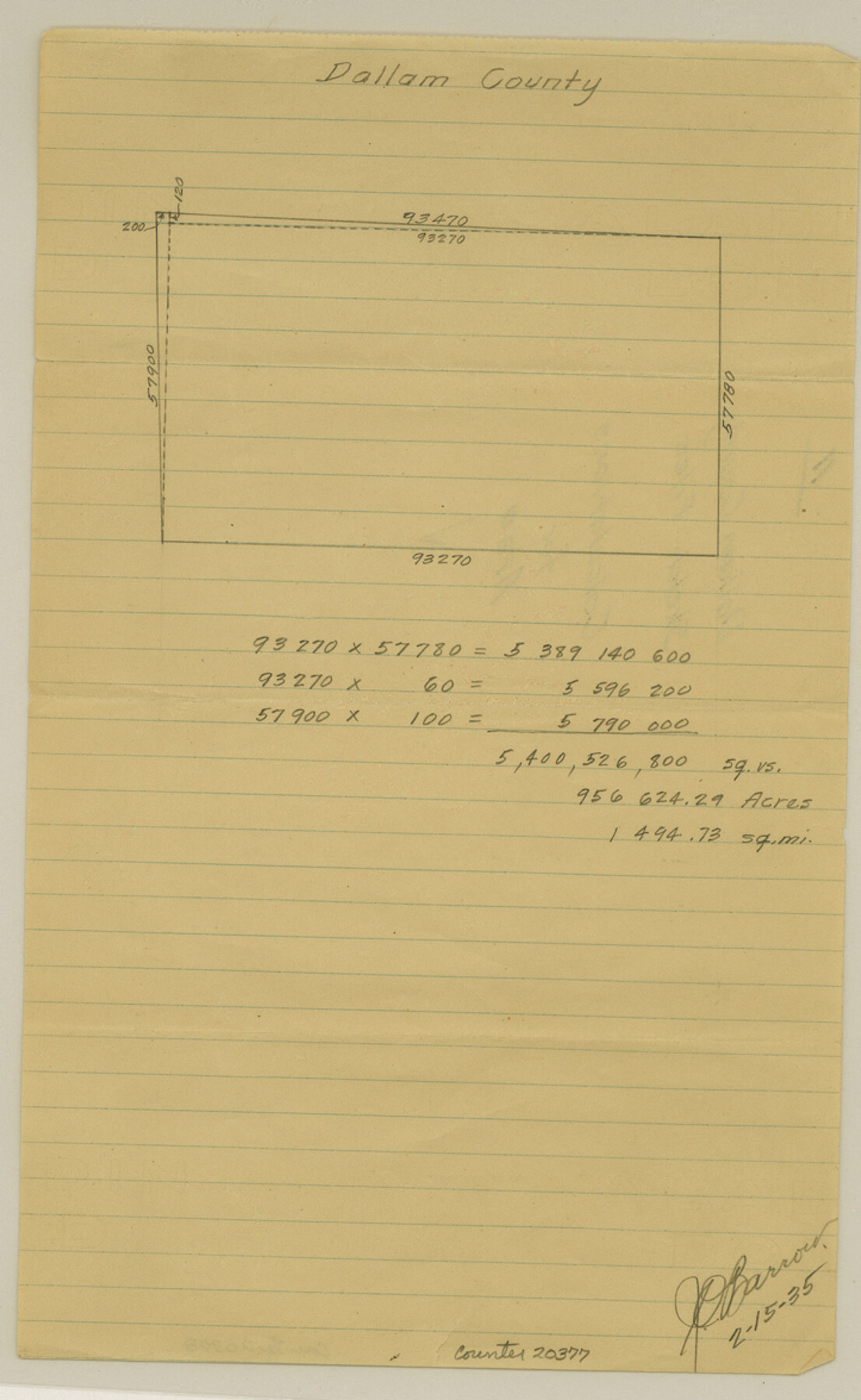
Dallam County Sketch File 11
[Calculations of area of Dallam County]
-
Map/Doc
20377
-
Collection
General Map Collection
-
Object Dates
1935/2/15 (Creation Date)
-
People and Organizations
J.O. Barrow (Surveyor/Engineer)
-
Counties
Dallam
-
Subjects
Surveying Sketch File
-
Height x Width
11.8 x 7.2 inches
30.0 x 18.3 cm
-
Medium
paper, manuscript
Part of: General Map Collection
Rio Grande, Fernando Sheet

Print $4.00
- Digital $50.00
Rio Grande, Fernando Sheet
1935
Size 20.8 x 25.8 inches
Map/Doc 65114

Hunt County Boundary File 5

Print $6.00
- Digital $50.00
Hunt County Boundary File 5
Size 11.2 x 8.9 inches
Map/Doc 55222
Flight Mission No. CLL-1N, Frame 195, Willacy County

Print $20.00
- Digital $50.00
Flight Mission No. CLL-1N, Frame 195, Willacy County
1954
Size 18.5 x 22.3 inches
Map/Doc 87065

Calhoun County Rolled Sketch 11

Print $20.00
- Digital $50.00
Calhoun County Rolled Sketch 11
1942
Size 10.6 x 40.7 inches
Map/Doc 5367
McClennan County

Print $20.00
- Digital $50.00
McClennan County
1880
Size 23.6 x 25.4 inches
Map/Doc 4596
Harris County Historic Topographic 16

Print $20.00
- Digital $50.00
Harris County Historic Topographic 16
1916
Size 29.3 x 22.9 inches
Map/Doc 65826
Kent County Boundary File 8

Print $20.00
- Digital $50.00
Kent County Boundary File 8
Size 14.2 x 8.6 inches
Map/Doc 55873
No. 3 Chart of Channel connecting Corpus Christi Bay with Aransas Bay, Texas

Print $20.00
- Digital $50.00
No. 3 Chart of Channel connecting Corpus Christi Bay with Aransas Bay, Texas
1848
Size 18.3 x 27.9 inches
Map/Doc 72777
Map of the Houston & Tex. Cen. R.R. from Dallas, Dallas Co., to McKinney, Collin Co.

Print $20.00
- Digital $50.00
Map of the Houston & Tex. Cen. R.R. from Dallas, Dallas Co., to McKinney, Collin Co.
1873
Size 23.0 x 43.8 inches
Map/Doc 64474
Sulphur River, Talco Sheet

Print $20.00
- Digital $50.00
Sulphur River, Talco Sheet
1917
Size 24.6 x 43.7 inches
Map/Doc 65160
You may also like
Mustang Island

Print $20.00
- Digital $50.00
Mustang Island
1945
Size 42.8 x 42.6 inches
Map/Doc 77469
Lampasas County Boundary File 9

Print $6.00
- Digital $50.00
Lampasas County Boundary File 9
Size 11.2 x 8.7 inches
Map/Doc 56181

Brazos River Conservation and Reclamation District Official Boundary Line Survey

Print $20.00
- Digital $50.00
Brazos River Conservation and Reclamation District Official Boundary Line Survey
Size 36.8 x 24.8 inches
Map/Doc 90126
Refugio County Boundary File 1

Print $6.00
- Digital $50.00
Refugio County Boundary File 1
Size 8.1 x 3.4 inches
Map/Doc 58225
Randall County Sketch File 2

Print $4.00
- Digital $50.00
Randall County Sketch File 2
1913
Size 7.3 x 8.8 inches
Map/Doc 34961
Archer County Sketch File B-1

Print $40.00
- Digital $50.00
Archer County Sketch File B-1
Size 34.5 x 38.8 inches
Map/Doc 10370
Gulf Coast of the United States, Key West to Rio Grande

Print $20.00
- Digital $50.00
Gulf Coast of the United States, Key West to Rio Grande
1863
Size 18.3 x 27.2 inches
Map/Doc 72667
[Blocks 44 and 6T]
![91410, [Blocks 44 and 6T], Twichell Survey Records](https://historictexasmaps.com/wmedia_w700/maps/91410-1.tif.jpg)
Print $20.00
- Digital $50.00
[Blocks 44 and 6T]
Size 29.3 x 17.4 inches
Map/Doc 91410
Bell County Rolled Sketch 1

Print $20.00
- Digital $50.00
Bell County Rolled Sketch 1
1954
Size 39.7 x 43.2 inches
Map/Doc 8445
Oldham County Sketch File 8

Print $4.00
- Digital $50.00
Oldham County Sketch File 8
Size 7.9 x 11.9 inches
Map/Doc 33239
Subdivision Map of Fisher County School Land situated in Bailey and Cochran Counties, Texas

Print $20.00
- Digital $50.00
Subdivision Map of Fisher County School Land situated in Bailey and Cochran Counties, Texas
1924
Size 17.3 x 21.3 inches
Map/Doc 90111