Crockett County Sketch File 33
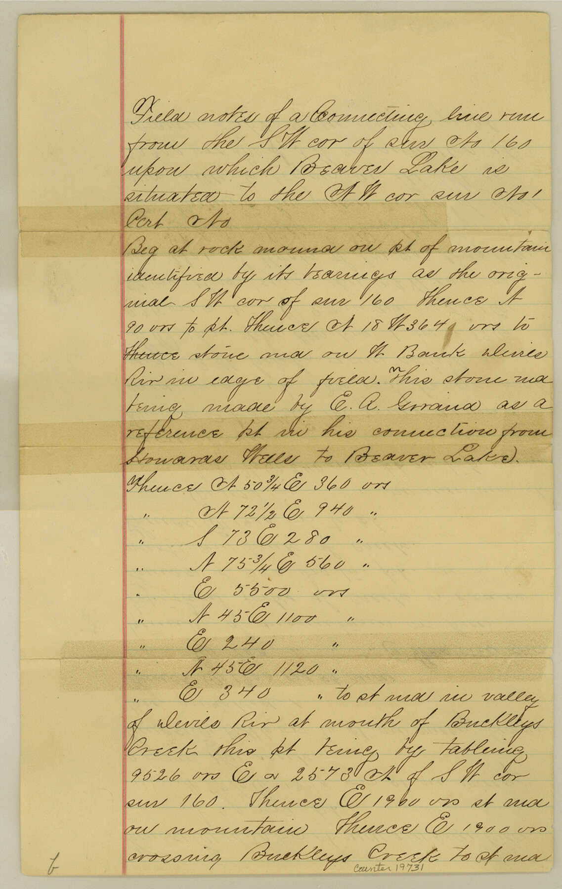
[Field notes and sketch of a connecting line from the southwest corner of survey 160, G. C. & S. F. R.R. Co. Block E - Beaver Lake - to the northwest corner of survey 1, C. & M. R.R. Co. Block A]
-
Map/Doc
19731
-
Collection
General Map Collection
-
Object Dates
11/1883 (Creation Date)
10/27/1884 (File Date)
-
People and Organizations
W.H. Bonnell (Surveyor/Engineer)
-
Counties
Val Verde
-
Subjects
Surveying Sketch File
-
Height x Width
13.0 x 8.2 inches
33.0 x 20.8 cm
-
Medium
paper, manuscript
-
Features
Beaver Lake
Devil's River
Howard's Wells
Buckley's Creek
Related maps
Val Verde County Sketch File 2

Print $8.00
- Digital $50.00
Val Verde County Sketch File 2
1885
Size 12.8 x 8.0 inches
Map/Doc 39169
Part of: General Map Collection
Comal County Rolled Sketch 3

Print $20.00
- Digital $50.00
Comal County Rolled Sketch 3
1977
Size 19.0 x 17.3 inches
Map/Doc 5538
Political Essay on the Kingdom of New Spain Vol. 4

Political Essay on the Kingdom of New Spain Vol. 4
1822
Map/Doc 97389
Kleberg County Aerial Photograph Index Sheet 3

Print $20.00
- Digital $50.00
Kleberg County Aerial Photograph Index Sheet 3
1956
Size 19.1 x 23.4 inches
Map/Doc 83720
Galveston County NRC Article 33.136 Sketch 10

Print $48.00
- Digital $50.00
Galveston County NRC Article 33.136 Sketch 10
2000
Size 29.8 x 41.9 inches
Map/Doc 61592
Travis County Working Sketch 19

Print $20.00
- Digital $50.00
Travis County Working Sketch 19
1945
Size 32.2 x 40.6 inches
Map/Doc 69403
Lipscomb County Boundary File 12

Print $4.00
- Digital $50.00
Lipscomb County Boundary File 12
Size 10.6 x 8.1 inches
Map/Doc 56351
Terrell County Rolled Sketch 50

Print $20.00
- Digital $50.00
Terrell County Rolled Sketch 50
1963
Size 35.9 x 20.5 inches
Map/Doc 7967
Flight Mission No. DAH-9M, Frame 156, Orange County

Print $20.00
- Digital $50.00
Flight Mission No. DAH-9M, Frame 156, Orange County
1953
Size 18.6 x 22.4 inches
Map/Doc 86855
1988 Land Use - El Paso, Ciudad Juarez and Vicinity

Print $20.00
- Digital $50.00
1988 Land Use - El Paso, Ciudad Juarez and Vicinity
1988
Size 34.2 x 25.1 inches
Map/Doc 87369
Schleicher County Working Sketch 6

Print $20.00
- Digital $50.00
Schleicher County Working Sketch 6
1917
Size 24.6 x 19.3 inches
Map/Doc 63808
Sterling County Sketch File 20

Print $12.00
- Digital $50.00
Sterling County Sketch File 20
1952
Size 11.2 x 8.7 inches
Map/Doc 37173
Hays County Sketch File 12

Print $4.00
- Digital $50.00
Hays County Sketch File 12
1866
Size 8.5 x 7.2 inches
Map/Doc 26218
You may also like
Navarro County Rolled Sketch 3

Print $20.00
- Digital $50.00
Navarro County Rolled Sketch 3
1893
Size 15.3 x 18.6 inches
Map/Doc 6838
[Atchison, Topeka & Santa Fe from Paisano to south of Plata]
![64712, [Atchison, Topeka & Santa Fe from Paisano to south of Plata], General Map Collection](https://historictexasmaps.com/wmedia_w700/maps/64712-1.tif.jpg)
Print $40.00
- Digital $50.00
[Atchison, Topeka & Santa Fe from Paisano to south of Plata]
Size 32.3 x 121.5 inches
Map/Doc 64712
[San Antonio & Galveston RR]
![64149, [San Antonio & Galveston RR], General Map Collection](https://historictexasmaps.com/wmedia_w700/maps/64149.tif.jpg)
Print $20.00
- Digital $50.00
[San Antonio & Galveston RR]
Size 37.6 x 11.2 inches
Map/Doc 64149
Archer County Sketch File 8

Print $40.00
- Digital $50.00
Archer County Sketch File 8
Size 40.9 x 31.5 inches
Map/Doc 10336

Map of Cass Co.

Print $20.00
- Digital $50.00
Map of Cass Co.
1862
Size 17.8 x 19.6 inches
Map/Doc 3372
Kimble County Working Sketch 55

Print $20.00
- Digital $50.00
Kimble County Working Sketch 55
1954
Size 14.3 x 30.1 inches
Map/Doc 70123
University of Texas System University Lands

Print $20.00
- Digital $50.00
University of Texas System University Lands
1938
Size 17.8 x 23.4 inches
Map/Doc 93247
Map of Zavalla County

Print $20.00
- Digital $50.00
Map of Zavalla County
1876
Size 22.5 x 33.2 inches
Map/Doc 4181
Bastrop County Working Sketch 6

Print $20.00
- Digital $50.00
Bastrop County Working Sketch 6
1923
Size 37.5 x 31.2 inches
Map/Doc 67306
Webb County Sketch File 62

Print $6.00
- Digital $50.00
Webb County Sketch File 62
1946
Size 11.5 x 9.0 inches
Map/Doc 39862
Flight Mission No. CUG-1P, Frame 81, Kleberg County

Print $20.00
- Digital $50.00
Flight Mission No. CUG-1P, Frame 81, Kleberg County
1956
Size 18.5 x 22.2 inches
Map/Doc 86146