Pecos County Rolled Sketch 151
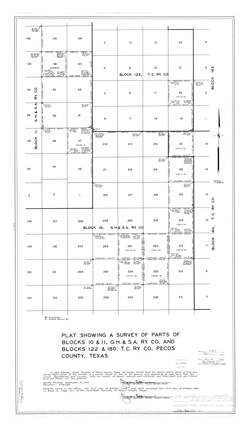
Plat showing a survey of parts of Blocks 10 & 11, G. H. & S. A. Ry. Co., and Blocks 122 & 180, T. C. Ry. Co., Pecos County, Texas
-
Map/Doc
7281
-
Collection
General Map Collection
-
Object Dates
1959/9/25 (Survey Date)
1959/10/28 (File Date)
-
People and Organizations
Jack Silliman (Surveyor/Engineer)
-
Counties
Pecos
-
Subjects
Surveying Rolled Sketch
-
Height x Width
40.6 x 23.6 inches
103.1 x 59.9 cm
-
Scale
1" = 800 varas
Part of: General Map Collection
Orange County Sketch File 39

Print $20.00
- Digital $50.00
Orange County Sketch File 39
1964
Size 24.2 x 27.9 inches
Map/Doc 12127
Chambers County Sketch File 41

Print $32.00
- Digital $50.00
Chambers County Sketch File 41
Size 14.7 x 9.1 inches
Map/Doc 17694
University Lands Blocks 27 & 28, Pecos County

Print $20.00
- Digital $50.00
University Lands Blocks 27 & 28, Pecos County
1940
Size 33.6 x 21.1 inches
Map/Doc 2449
Rusk County Sketch File 17

Print $22.00
Rusk County Sketch File 17
1857
Size 12.7 x 15.7 inches
Map/Doc 35520
Edwards County Working Sketch 61

Print $20.00
- Digital $50.00
Edwards County Working Sketch 61
1954
Size 21.0 x 40.3 inches
Map/Doc 68937
Upton County Sketch File 6

Print $10.00
- Digital $50.00
Upton County Sketch File 6
1909
Size 11.3 x 8.6 inches
Map/Doc 38815
Hockley County

Print $20.00
- Digital $50.00
Hockley County
1954
Size 44.2 x 39.7 inches
Map/Doc 95531
Dickens County Sketch File 32

Print $20.00
- Digital $50.00
Dickens County Sketch File 32
Size 32.8 x 30.6 inches
Map/Doc 11328
Topographical Map of the Rio Grande, Sheet No. 5

Print $20.00
- Digital $50.00
Topographical Map of the Rio Grande, Sheet No. 5
1912
Map/Doc 89529
Jeff Davis County Sketch File 38

Print $8.00
- Digital $50.00
Jeff Davis County Sketch File 38
1952
Size 14.3 x 9.1 inches
Map/Doc 28054
Angelina County Sketch File 26

Print $40.00
- Digital $50.00
Angelina County Sketch File 26
1909
Size 18.0 x 23.0 inches
Map/Doc 10817
Young County Sketch File 5

Print $40.00
- Digital $50.00
Young County Sketch File 5
1855
Size 12.8 x 15.6 inches
Map/Doc 49662
You may also like
Upton County Rolled Sketch 36

Print $40.00
- Digital $50.00
Upton County Rolled Sketch 36
1952
Size 42.9 x 64.2 inches
Map/Doc 10051
Upshur County Rolled Sketch 4

Print $20.00
- Digital $50.00
Upshur County Rolled Sketch 4
1972
Size 25.4 x 37.9 inches
Map/Doc 8063
Flight Mission No. DQN-2K, Frame 139, Calhoun County

Print $20.00
- Digital $50.00
Flight Mission No. DQN-2K, Frame 139, Calhoun County
1953
Size 16.3 x 16.2 inches
Map/Doc 84308
Jefferson County Rolled Sketch 30

Print $20.00
- Digital $50.00
Jefferson County Rolled Sketch 30
1954
Size 34.1 x 39.9 inches
Map/Doc 6392
Chambers County Sketch File 34

Print $10.00
- Digital $50.00
Chambers County Sketch File 34
1951
Size 14.3 x 8.8 inches
Map/Doc 17620
Ellis County Sketch File 16

Print $4.00
- Digital $50.00
Ellis County Sketch File 16
Size 13.1 x 8.3 inches
Map/Doc 21858
Brazoria County NRC Article 33.136 Sketch 21

Print $34.00
Brazoria County NRC Article 33.136 Sketch 21
2018
Map/Doc 97241
Roberts County Working Sketch 47

Print $20.00
- Digital $50.00
Roberts County Working Sketch 47
1996
Size 19.6 x 34.7 inches
Map/Doc 63573
Flight Mission No. DAG-23K, Frame 179, Matagorda County

Print $20.00
- Digital $50.00
Flight Mission No. DAG-23K, Frame 179, Matagorda County
1953
Size 18.5 x 22.4 inches
Map/Doc 86514
Pecos County Rolled Sketch 89

Print $40.00
- Digital $50.00
Pecos County Rolled Sketch 89
1934
Size 56.2 x 41.4 inches
Map/Doc 10719
Real County Working Sketch 91

Print $20.00
- Digital $50.00
Real County Working Sketch 91
1996
Size 22.0 x 20.0 inches
Map/Doc 71983
Panola County Working Sketch 24

Print $20.00
- Digital $50.00
Panola County Working Sketch 24
1957
Map/Doc 71433