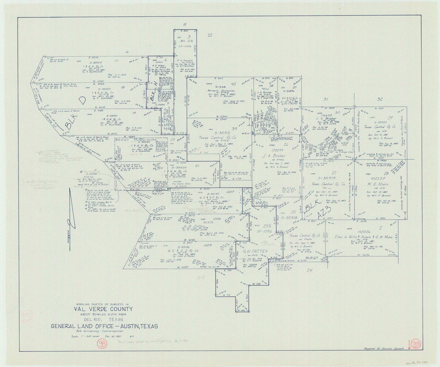
Val Verde County Working Sketch 98
-
Map/Doc
72233
-
Collection
General Map Collection
-
Object Dates
12/18/1980 (Creation Date)
-
People and Organizations
Beverly Robison (Draftsman)
-
Counties
Val Verde
-
Subjects
Surveying Working Sketch
-
Height x Width
26.5 x 31.8 inches
67.3 x 80.8 cm
-
Scale
1' = 500 varas
Part of: General Map Collection
Kenedy County Rolled Sketch 13

Print $20.00
- Digital $50.00
Kenedy County Rolled Sketch 13
1946
Size 38.2 x 45.5 inches
Map/Doc 9334
Map of a part of Laguna Madre in Willacy & Cameron Counties showing subdivision for mineral development

Print $20.00
- Digital $50.00
Map of a part of Laguna Madre in Willacy & Cameron Counties showing subdivision for mineral development
1950
Size 46.9 x 37.0 inches
Map/Doc 3097
Val Verde County Sketch File XXX7

Print $6.00
- Digital $50.00
Val Verde County Sketch File XXX7
Size 11.0 x 15.4 inches
Map/Doc 39104

Galveston County NRC Article 33.136 Sketch 100

Print $46.00
Galveston County NRC Article 33.136 Sketch 100
2024
Map/Doc 97423
Jefferson County Sketch File 14

Print $60.00
- Digital $50.00
Jefferson County Sketch File 14
Size 15.8 x 13.2 inches
Map/Doc 28149
Lampasas County Working Sketch 8

Print $20.00
- Digital $50.00
Lampasas County Working Sketch 8
1958
Size 36.4 x 37.1 inches
Map/Doc 70285
Taylor County

Print $20.00
- Digital $50.00
Taylor County
1934
Size 44.4 x 38.9 inches
Map/Doc 73299
Flight Mission No. BRE-3P, Frame 81, Nueces County

Print $20.00
- Digital $50.00
Flight Mission No. BRE-3P, Frame 81, Nueces County
1956
Size 18.6 x 22.4 inches
Map/Doc 86822
Plot of surveys on Sims Bayou

Print $2.00
- Digital $50.00
Plot of surveys on Sims Bayou
1844
Size 6.8 x 8.3 inches
Map/Doc 26
Hamilton County Sketch File 10 1/2

Print $44.00
- Digital $50.00
Hamilton County Sketch File 10 1/2
1876
Size 9.2 x 8.3 inches
Map/Doc 24931
Van Zandt County Sketch File 22a

Print $4.00
- Digital $50.00
Van Zandt County Sketch File 22a
1858
Size 7.5 x 8.2 inches
Map/Doc 39435
You may also like
Real County Working Sketch 69

Print $20.00
- Digital $50.00
Real County Working Sketch 69
1942
Size 42.4 x 35.4 inches
Map/Doc 71961
Dickens County

Print $20.00
- Digital $50.00
Dickens County
1880
Size 20.8 x 19.1 inches
Map/Doc 3485
Val Verde County Rolled Sketch 62

Print $40.00
- Digital $50.00
Val Verde County Rolled Sketch 62
1956
Size 34.6 x 52.1 inches
Map/Doc 10081
Gonzales County

Print $20.00
- Digital $50.00
Gonzales County
1853
Size 23.4 x 22.4 inches
Map/Doc 3591
J. B. Chilton's Subdivision of League 289, Gaines County, Texas

Print $20.00
- Digital $50.00
J. B. Chilton's Subdivision of League 289, Gaines County, Texas
1924
Size 18.7 x 24.7 inches
Map/Doc 92682
San Jacinto County Rolled Sketch 3

Print $40.00
- Digital $50.00
San Jacinto County Rolled Sketch 3
Size 24.4 x 59.4 inches
Map/Doc 9880
Matagorda County Sketch File 39

Print $20.00
- Digital $50.00
Matagorda County Sketch File 39
Size 31.1 x 24.3 inches
Map/Doc 12047
[Field Notes attached to Sketch of North Line of Deaf Smith County and South Line of Oldham County]
![91407, [Field Notes attached to Sketch of North Line of Deaf Smith County and South Line of Oldham County], Twichell Survey Records](https://historictexasmaps.com/wmedia_w700/maps/91407-1.tif.jpg)
Print $20.00
- Digital $50.00
[Field Notes attached to Sketch of North Line of Deaf Smith County and South Line of Oldham County]
1894
Size 40.6 x 20.0 inches
Map/Doc 91407
Pecos County Sketch File 1A

Print $20.00
- Digital $50.00
Pecos County Sketch File 1A
1919
Size 34.3 x 23.7 inches
Map/Doc 12155
Working Sketch in Bastrop County

Print $20.00
- Digital $50.00
Working Sketch in Bastrop County
1921
Size 14.4 x 22.9 inches
Map/Doc 90205
Mason County Sketch File 22

Print $8.00
- Digital $50.00
Mason County Sketch File 22
1932
Size 11.1 x 8.9 inches
Map/Doc 30719
Lipscomb County Working Sketch 9

Print $20.00
- Digital $50.00
Lipscomb County Working Sketch 9
1995
Size 44.1 x 22.3 inches
Map/Doc 70585