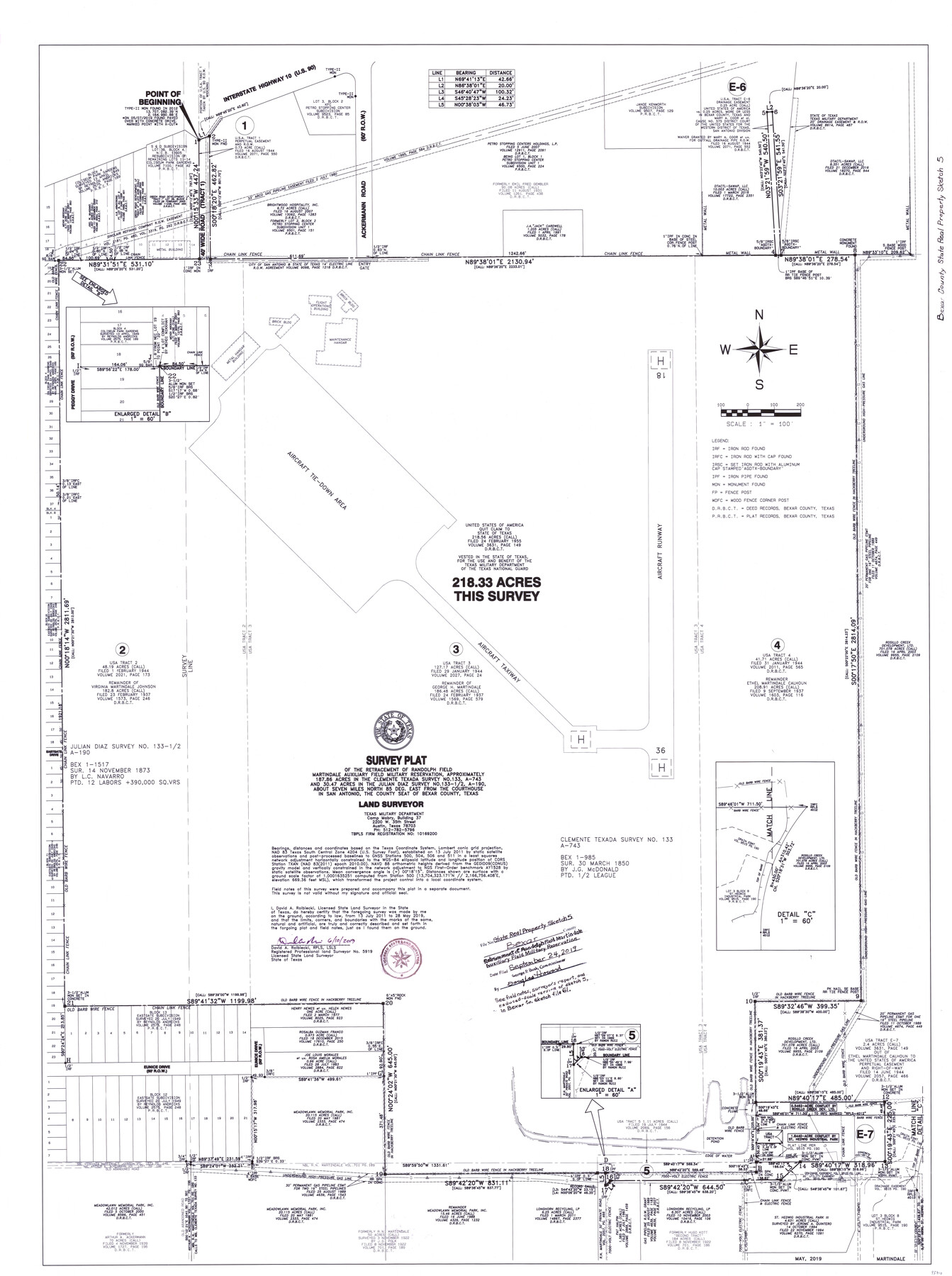
Bexar County State Real Property Sketch 5
Survey plat of the retracement of Randolph Field Martindale Auxiliary Field Military Reservation, approximately 187.86 acres in the Clemente Texada survey no. 133, A-743 and 30.47 acres in the Julian Diaz survey no. 133 1/2, A-190
-
Map/Doc
95710
-
Collection
General Map Collection
-
Object Dates
2019/6/10 (Creation Date)
2019/9/24 (File Date)
-
People and Organizations
David A. Rolbiecki (Surveyor/Engineer)
-
Counties
Bexar
-
Subjects
State Real Property
-
Height x Width
48.0 x 35.8 inches
121.9 x 90.9 cm
-
Medium
mylar, print
-
Scale
1" = 100'
-
Comments
See Bexar County Sketch File 61 (95709) for field notes and surveyor's report
Related maps
Bexar County Sketch File 61

Print $61.00
- Digital $50.00
Bexar County Sketch File 61
2019
Size 11.0 x 8.5 inches
Map/Doc 95709
Part of: General Map Collection
Rio Grande, Brownsville Sheet No. 2

Print $4.00
- Digital $50.00
Rio Grande, Brownsville Sheet No. 2
1924
Size 21.2 x 28.3 inches
Map/Doc 65131
Liberty County Working Sketch 46

Print $20.00
- Digital $50.00
Liberty County Working Sketch 46
1953
Size 18.6 x 37.6 inches
Map/Doc 70505
Maps of Gulf Intracoastal Waterway, Texas - Sabine River to the Rio Grande and connecting waterways including ship channels

Print $20.00
- Digital $50.00
Maps of Gulf Intracoastal Waterway, Texas - Sabine River to the Rio Grande and connecting waterways including ship channels
1966
Size 14.5 x 22.2 inches
Map/Doc 61974
Current Miscellaneous File 74

Print $14.00
- Digital $50.00
Current Miscellaneous File 74
1850
Size 11.2 x 8.7 inches
Map/Doc 74181
[Texas & Pacific Railway through Callahan County]
![64233, [Texas & Pacific Railway through Callahan County], General Map Collection](https://historictexasmaps.com/wmedia_w700/maps/64233.tif.jpg)
Print $20.00
- Digital $50.00
[Texas & Pacific Railway through Callahan County]
1918
Size 20.5 x 9.4 inches
Map/Doc 64233
Parker County Working Sketch 7

Print $20.00
- Digital $50.00
Parker County Working Sketch 7
1955
Map/Doc 71457
Wichita County Boundary File 2b

Print $4.00
- Digital $50.00
Wichita County Boundary File 2b
Size 8.9 x 8.8 inches
Map/Doc 59911
Harris County Sketch File 69

Print $12.00
- Digital $50.00
Harris County Sketch File 69
1938
Size 11.5 x 8.8 inches
Map/Doc 25512
[Surveys in the Nacogdoches District, Rusk County]
![339, [Surveys in the Nacogdoches District, Rusk County], General Map Collection](https://historictexasmaps.com/wmedia_w700/maps/339.tif.jpg)
Print $2.00
- Digital $50.00
[Surveys in the Nacogdoches District, Rusk County]
Size 6.0 x 8.2 inches
Map/Doc 339
Rusk County Working Sketch 30

Print $20.00
- Digital $50.00
Rusk County Working Sketch 30
1931
Size 22.9 x 21.4 inches
Map/Doc 63667
Runnels County Working Sketch 14

Print $20.00
- Digital $50.00
Runnels County Working Sketch 14
1950
Size 28.4 x 26.8 inches
Map/Doc 63610
Edwards County Working Sketch 111

Print $40.00
- Digital $50.00
Edwards County Working Sketch 111
1972
Size 58.1 x 30.8 inches
Map/Doc 68987
You may also like
Aransas County NRC Article 33.136 Sketch 12

Print $44.00
- Digital $50.00
Aransas County NRC Article 33.136 Sketch 12
2012
Size 36.0 x 48.0 inches
Map/Doc 94510
Zavala County Sketch File 40

Print $20.00
- Digital $50.00
Zavala County Sketch File 40
1901
Size 14.4 x 8.9 inches
Map/Doc 41406
Kimble County Working Sketch 69

Print $20.00
- Digital $50.00
Kimble County Working Sketch 69
1965
Size 42.4 x 30.5 inches
Map/Doc 70137
Hudspeth County Rolled Sketch 76

Print $40.00
- Digital $50.00
Hudspeth County Rolled Sketch 76
1992
Size 49.5 x 37.7 inches
Map/Doc 9239
[Area around Gillespie County, Bastrop County and El Paso County School Land Leagues]
![90866, [Area around Gillespie County, Bastrop County and El Paso County School Land Leagues], Twichell Survey Records](https://historictexasmaps.com/wmedia_w700/maps/90866-2.tif.jpg)
Print $20.00
- Digital $50.00
[Area around Gillespie County, Bastrop County and El Paso County School Land Leagues]
1886
Size 25.7 x 29.8 inches
Map/Doc 90866
Clay County Boundary File 16

Print $56.00
- Digital $50.00
Clay County Boundary File 16
Size 9.1 x 3.7 inches
Map/Doc 51422
Crockett County Rolled Sketch P

Print $20.00
- Digital $50.00
Crockett County Rolled Sketch P
1927
Size 24.3 x 47.3 inches
Map/Doc 8696
Lynn County Rolled Sketch 17

Print $20.00
- Digital $50.00
Lynn County Rolled Sketch 17
1994
Size 45.2 x 35.8 inches
Map/Doc 9475
Harrison County Working Sketch 18

Print $20.00
- Digital $50.00
Harrison County Working Sketch 18
1976
Size 37.0 x 40.1 inches
Map/Doc 66038
[Surveys near the Neches River]
![8, [Surveys near the Neches River], General Map Collection](https://historictexasmaps.com/wmedia_w700/maps/8.tif.jpg)
Print $3.00
- Digital $50.00
[Surveys near the Neches River]
Size 17.2 x 10.3 inches
Map/Doc 8
[F. W. & D. C. Ry. Co. Alignment and Right of Way Map, Clay County]
![64728, [F. W. & D. C. Ry. Co. Alignment and Right of Way Map, Clay County], General Map Collection](https://historictexasmaps.com/wmedia_w700/maps/64728-1.tif.jpg)
Print $20.00
- Digital $50.00
[F. W. & D. C. Ry. Co. Alignment and Right of Way Map, Clay County]
1927
Size 18.8 x 11.7 inches
Map/Doc 64728
Crane County Rolled Sketch 24

Print $40.00
- Digital $50.00
Crane County Rolled Sketch 24
2002
Size 33.5 x 62.0 inches
Map/Doc 76427