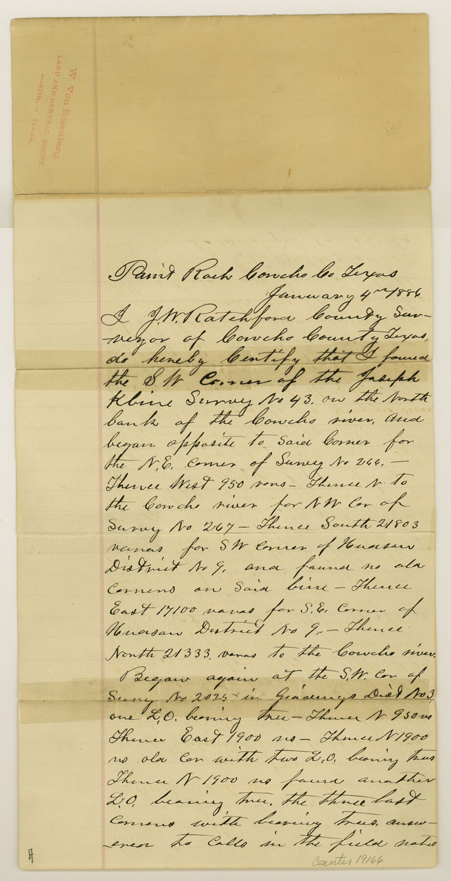
Concho County Sketch File 28
[Letter in regard to the resurvey of Blocks 8 and 9]
-
Map/Doc
19166
-
Collection
General Map Collection
-
Object Dates
1887/3/24 (Creation Date)
-
People and Organizations
J.W. Ratchford (Surveyor/Engineer)
-
Counties
Concho
-
Subjects
Surveying Sketch File
-
Height x Width
16.2 x 8.3 inches
41.1 x 21.1 cm
-
Medium
paper, manuscript
-
Features
Concho River
Part of: General Map Collection
Borden and Garza County Boundary Line Plat

Print $2.00
- Digital $50.00
Borden and Garza County Boundary Line Plat
1965
Size 14.2 x 8.8 inches
Map/Doc 61152
Flight Mission No. BRA-16M, Frame 117, Jefferson County

Print $20.00
- Digital $50.00
Flight Mission No. BRA-16M, Frame 117, Jefferson County
1953
Size 18.7 x 22.1 inches
Map/Doc 85727
Chart showing the positions of the lights in the Eighth L. H. District extending from the Perdido River, Florida to the Rio Grande, Texas

Print $20.00
- Digital $50.00
Chart showing the positions of the lights in the Eighth L. H. District extending from the Perdido River, Florida to the Rio Grande, Texas
1876
Size 24.7 x 18.2 inches
Map/Doc 72682
Flight Mission No. DCL-5C, Frame 66, Kenedy County

Print $20.00
- Digital $50.00
Flight Mission No. DCL-5C, Frame 66, Kenedy County
1943
Size 18.4 x 22.3 inches
Map/Doc 85849

Supreme Court of the United States, October Term, 1930, No.2, Original - The State of New Mexico, Complainant vs. The State of Texas, Defendant

Print $138.00
- Digital $50.00
Supreme Court of the United States, October Term, 1930, No.2, Original - The State of New Mexico, Complainant vs. The State of Texas, Defendant
Size 9.2 x 6.0 inches
Map/Doc 95287
Brewster County Rolled Sketch 60

Print $40.00
- Digital $50.00
Brewster County Rolled Sketch 60
Size 36.7 x 50.8 inches
Map/Doc 9200
Jasper County Working Sketch 19

Print $20.00
- Digital $50.00
Jasper County Working Sketch 19
1939
Size 15.8 x 15.8 inches
Map/Doc 66481
E. N. Gustafson's survey of Southern Portion of Lake Austin, Matagorda Co., TX

Print $20.00
- Digital $50.00
E. N. Gustafson's survey of Southern Portion of Lake Austin, Matagorda Co., TX
1926
Size 36.7 x 42.7 inches
Map/Doc 2922
Travis County Appraisal District Plat Map 2_2813

Print $20.00
- Digital $50.00
Travis County Appraisal District Plat Map 2_2813
Size 21.5 x 26.5 inches
Map/Doc 94217
Flight Mission No. BRE-1P, Frame 123, Nueces County

Print $20.00
- Digital $50.00
Flight Mission No. BRE-1P, Frame 123, Nueces County
1956
Size 18.6 x 22.7 inches
Map/Doc 86689
[Sketch for Mineral Application 12206 - Cow Bayou, O. B. Sawyer]
![65569, [Sketch for Mineral Application 12206 - Cow Bayou, O. B. Sawyer], General Map Collection](https://historictexasmaps.com/wmedia_w700/maps/65569.tif.jpg)
Print $40.00
- Digital $50.00
[Sketch for Mineral Application 12206 - Cow Bayou, O. B. Sawyer]
Size 63.3 x 36.5 inches
Map/Doc 65569
You may also like
G. C. & S. F., Main Line, Texas, Right of Way map, Rio Vista to Crowley

Print $40.00
- Digital $50.00
G. C. & S. F., Main Line, Texas, Right of Way map, Rio Vista to Crowley
1916
Size 40.2 x 92.0 inches
Map/Doc 64654
Ward County Boundary File 3a

Print $22.00
- Digital $50.00
Ward County Boundary File 3a
Size 13.1 x 8.6 inches
Map/Doc 59684
Comanche County Sketch File 24 1/2

Print $6.00
- Digital $50.00
Comanche County Sketch File 24 1/2
Size 10.5 x 15.8 inches
Map/Doc 19113
Lampasas County Boundary File Index

Print $2.00
- Digital $50.00
Lampasas County Boundary File Index
Size 9.0 x 9.6 inches
Map/Doc 56092
Nueces County Rolled Sketch 92

Print $222.00
Nueces County Rolled Sketch 92
1983
Size 24.6 x 43.7 inches
Map/Doc 7028
Jno. W. Pritchett Preliminary Official LO Map for Lubbock [County]
![89901, Jno. W. Pritchett Preliminary Official LO Map for Lubbock [County], Twichell Survey Records](https://historictexasmaps.com/wmedia_w700/maps/89901-1.tif.jpg)
Print $20.00
- Digital $50.00
Jno. W. Pritchett Preliminary Official LO Map for Lubbock [County]
Size 41.1 x 40.3 inches
Map/Doc 89901
General Highway Map, Navarro County, Texas

Print $20.00
General Highway Map, Navarro County, Texas
1939
Size 24.6 x 18.5 inches
Map/Doc 79207
[Located Line of the Panhandle & Gulf Ry. through State Lands]
![64103, [Located Line of the Panhandle & Gulf Ry. through State Lands], General Map Collection](https://historictexasmaps.com/wmedia_w700/maps/64103.tif.jpg)
Print $40.00
- Digital $50.00
[Located Line of the Panhandle & Gulf Ry. through State Lands]
1904
Size 12.4 x 121.6 inches
Map/Doc 64103
Schleicher County Sketch File 37

Print $20.00
- Digital $50.00
Schleicher County Sketch File 37
1952
Size 24.9 x 29.3 inches
Map/Doc 12310

Marion County Working Sketch 28

Print $20.00
- Digital $50.00
Marion County Working Sketch 28
1975
Size 24.0 x 33.5 inches
Map/Doc 70804
Runnels County Sketch File 21

Print $5.00
Runnels County Sketch File 21
Size 11.7 x 15.6 inches
Map/Doc 35488