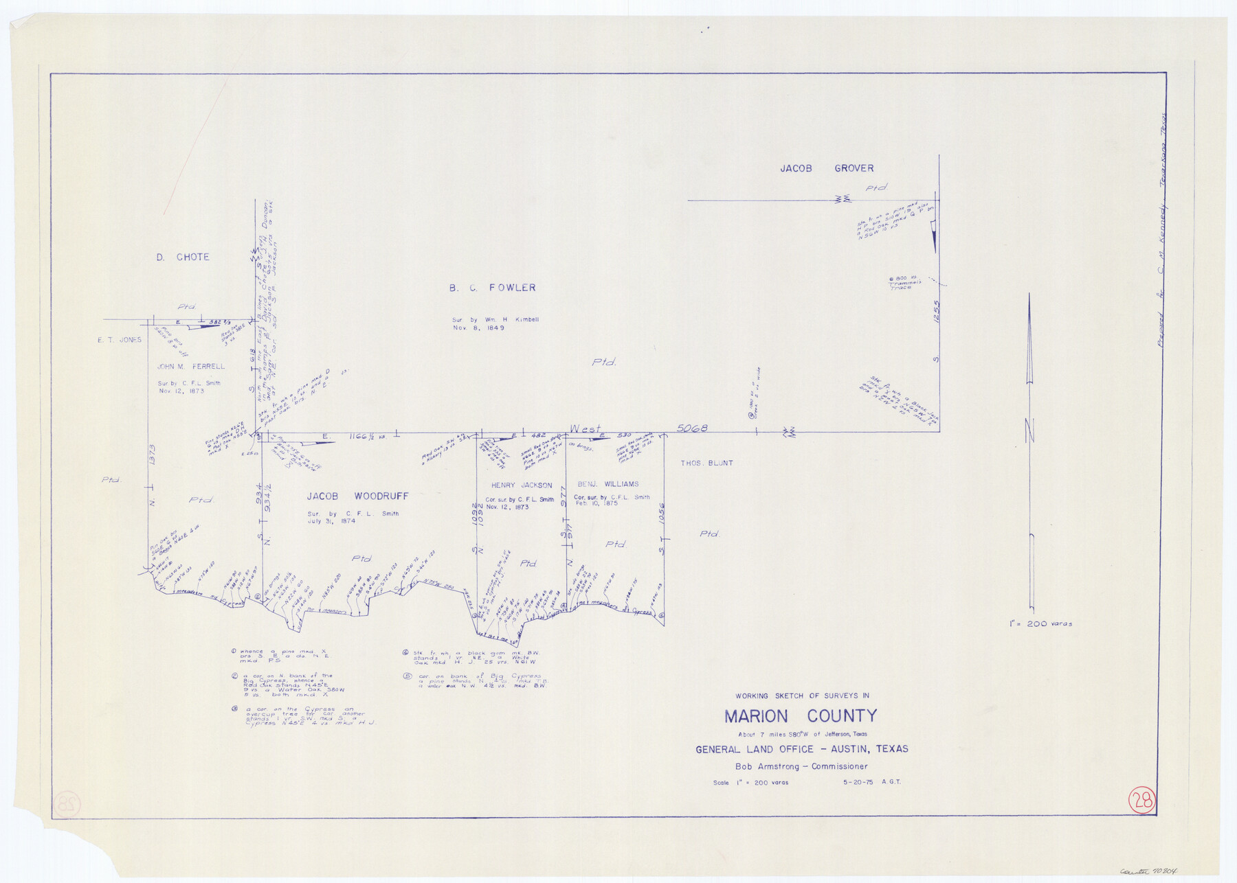
Marion County Working Sketch 28
-
Map/Doc
70804
-
Collection
General Map Collection
-
Object Dates
5/20/1975 (Creation Date)
-
People and Organizations
Abner G. Trigg (Draftsman)
-
Counties
Marion
-
Subjects
Surveying Working Sketch
-
Height x Width
24.0 x 33.5 inches
61.0 x 85.1 cm
-
Scale
1" = 200 varas
Part of: General Map Collection
Hardin County Working Sketch 1

Print $20.00
- Digital $50.00
Hardin County Working Sketch 1
1903
Size 27.8 x 18.7 inches
Map/Doc 63399
Presidio County Rolled Sketch 140

Print $20.00
- Digital $50.00
Presidio County Rolled Sketch 140
2003
Size 44.4 x 34.7 inches
Map/Doc 78654
Brewster County Rolled Sketch 101

Print $40.00
- Digital $50.00
Brewster County Rolled Sketch 101
1927
Size 73.0 x 44.9 inches
Map/Doc 8923
Map of Newton County

Print $40.00
- Digital $50.00
Map of Newton County
1894
Size 69.8 x 28.4 inches
Map/Doc 82078
Webb County Boundary File 4

Print $8.00
- Digital $50.00
Webb County Boundary File 4
Size 11.2 x 8.8 inches
Map/Doc 59761
Right of Way & Track Map San Antonio & Aransas Pass Railway Co.

Print $40.00
- Digital $50.00
Right of Way & Track Map San Antonio & Aransas Pass Railway Co.
1919
Size 25.2 x 56.7 inches
Map/Doc 64040
County and Railroad Map of Texas

Print $20.00
- Digital $50.00
County and Railroad Map of Texas
1876
Size 17.0 x 16.0 inches
Map/Doc 93624

Flight Mission No. DCL-7C, Frame 140, Kenedy County

Print $20.00
- Digital $50.00
Flight Mission No. DCL-7C, Frame 140, Kenedy County
1943
Size 18.6 x 22.2 inches
Map/Doc 86097
Castro County Sketch File 4e

Print $4.00
- Digital $50.00
Castro County Sketch File 4e
Size 13.6 x 8.9 inches
Map/Doc 17473
Bell County Working Sketch 4

Print $20.00
- Digital $50.00
Bell County Working Sketch 4
1942
Size 26.9 x 21.0 inches
Map/Doc 67344

You may also like
Leon County Rolled Sketch 6

Print $20.00
- Digital $50.00
Leon County Rolled Sketch 6
1951
Size 31.7 x 37.1 inches
Map/Doc 6596
Lipscomb County Boundary File 6

Print $4.00
- Digital $50.00
Lipscomb County Boundary File 6
Size 11.1 x 8.6 inches
Map/Doc 56329
Right of Way & Track Map San Antonio & Aransas Pass Railway Co.

Print $40.00
- Digital $50.00
Right of Way & Track Map San Antonio & Aransas Pass Railway Co.
1919
Size 25.8 x 57.1 inches
Map/Doc 64027
Cooke County Working Sketch 6

Print $20.00
- Digital $50.00
Cooke County Working Sketch 6
1935
Size 21.4 x 22.1 inches
Map/Doc 68243
Cass County Rolled Sketch 4

Print $20.00
- Digital $50.00
Cass County Rolled Sketch 4
1946
Size 20.2 x 15.1 inches
Map/Doc 5410
Map of Portion of Pecos County as Surveyed by F. F. Friend

Print $20.00
- Digital $50.00
Map of Portion of Pecos County as Surveyed by F. F. Friend
1926
Size 18.8 x 15.5 inches
Map/Doc 91561
Map No. 2 - Surveys Corrected in 1882 as they appear on the ground

Print $20.00
- Digital $50.00
Map No. 2 - Surveys Corrected in 1882 as they appear on the ground
Size 30.8 x 18.5 inches
Map/Doc 91891
[Sketch for Mineral Application 33721 - 33725 Incl. - Padre and Mustang Island]
![2871, [Sketch for Mineral Application 33721 - 33725 Incl. - Padre and Mustang Island], General Map Collection](https://historictexasmaps.com/wmedia_w700/maps/2871.tif.jpg)
Print $20.00
- Digital $50.00
[Sketch for Mineral Application 33721 - 33725 Incl. - Padre and Mustang Island]
1942
Size 27.0 x 22.4 inches
Map/Doc 2871
Webb County Working Sketch 14

Print $20.00
- Digital $50.00
Webb County Working Sketch 14
1923
Size 19.3 x 32.2 inches
Map/Doc 72379
Corpus Christi Bay in Nueces County, showing Subdivision for Mineral Development

Print $40.00
- Digital $50.00
Corpus Christi Bay in Nueces County, showing Subdivision for Mineral Development
1950
Size 48.4 x 36.0 inches
Map/Doc 1917
Ellwood Farms Subdivision Number 2 of the Spade Ranch Lamb and Hale Counties, Texas

Print $20.00
- Digital $50.00
Ellwood Farms Subdivision Number 2 of the Spade Ranch Lamb and Hale Counties, Texas
Size 22.2 x 31.4 inches
Map/Doc 92258
Flight Mission No. CUG-1P, Frame 86, Kleberg County

Print $20.00
- Digital $50.00
Flight Mission No. CUG-1P, Frame 86, Kleberg County
1956
Size 18.5 x 22.2 inches
Map/Doc 86151