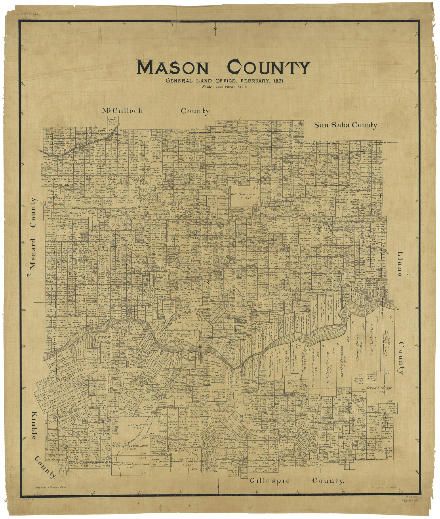
Mason County
RM-4-157
-
Map/Doc
1890
-
Collection
General Map Collection
-
Object Dates
2/1921 (Creation Date)
-
People and Organizations
Texas General Land Office (Publisher)
John D. Hedick (Compiler)
John D. Hedick (Draftsman)
-
Counties
Mason
-
Subjects
County
-
Height x Width
46.2 x 39.1 inches
117.4 x 99.3 cm
-
Comments
Traced by J. Bascom Giles.
Part of: General Map Collection
Uvalde County Sketch File 20

Print $40.00
- Digital $50.00
Uvalde County Sketch File 20
1882
Size 15.0 x 13.2 inches
Map/Doc 39002
Walker County Working Sketch 8

Print $20.00
- Digital $50.00
Walker County Working Sketch 8
1935
Size 40.8 x 41.7 inches
Map/Doc 72288
Flight Mission No. DCL-6C, Frame 23, Kenedy County

Print $20.00
- Digital $50.00
Flight Mission No. DCL-6C, Frame 23, Kenedy County
1943
Size 18.7 x 22.3 inches
Map/Doc 85880
Flight Mission No. DQN-2K, Frame 1, Calhoun County

Print $20.00
- Digital $50.00
Flight Mission No. DQN-2K, Frame 1, Calhoun County
1953
Size 18.5 x 22.2 inches
Map/Doc 84218
McMullen County Sketch File 44

Print $6.00
- Digital $50.00
McMullen County Sketch File 44
1942
Size 14.2 x 8.8 inches
Map/Doc 31426
Frio County Working Sketch 11

Print $20.00
- Digital $50.00
Frio County Working Sketch 11
1952
Size 22.9 x 20.0 inches
Map/Doc 69285
Uvalde County Boundary File 2

Print $5.00
- Digital $50.00
Uvalde County Boundary File 2
Size 13.1 x 9.5 inches
Map/Doc 59556
Midland County

Print $20.00
- Digital $50.00
Midland County
1901
Size 43.7 x 40.3 inches
Map/Doc 66929
Flight Mission No. DAG-17K, Frame 140, Matagorda County

Print $20.00
- Digital $50.00
Flight Mission No. DAG-17K, Frame 140, Matagorda County
1952
Size 16.5 x 16.1 inches
Map/Doc 86357
San Saba County Sketch File 4a

Print $4.00
- Digital $50.00
San Saba County Sketch File 4a
1854
Size 9.6 x 8.5 inches
Map/Doc 36410
Kenedy County Boundary File 2

Print $22.00
- Digital $50.00
Kenedy County Boundary File 2
Size 11.2 x 8.6 inches
Map/Doc 55782
Freestone County Sketch File 6

Print $4.00
- Digital $50.00
Freestone County Sketch File 6
1858
Size 10.3 x 8.8 inches
Map/Doc 23050
You may also like
Burnet County Sketch File 21

Print $4.00
- Digital $50.00
Burnet County Sketch File 21
Size 8.4 x 6.6 inches
Map/Doc 16714
Cass County Working Sketch 25

Print $20.00
- Digital $50.00
Cass County Working Sketch 25
1974
Size 46.5 x 35.8 inches
Map/Doc 67928
[Surveying sketch of M.K. McDermott, T. C. R.R. Co., I. & G. N. Ry. Co., et al in Williamson County]
![407, [Surveying sketch of M.K. McDermott, T. C. R.R. Co., I. & G. N. Ry. Co., et al in Williamson County], Maddox Collection](https://historictexasmaps.com/wmedia_w700/maps/407.tif.jpg)
Print $3.00
- Digital $50.00
[Surveying sketch of M.K. McDermott, T. C. R.R. Co., I. & G. N. Ry. Co., et al in Williamson County]
1889
Size 11.5 x 12.6 inches
Map/Doc 407
Upshur County Sketch File 13A

Print $20.00
- Digital $50.00
Upshur County Sketch File 13A
1936
Size 20.5 x 32.4 inches
Map/Doc 12503
Ward County Working Sketch 49

Print $40.00
- Digital $50.00
Ward County Working Sketch 49
1974
Size 54.8 x 37.1 inches
Map/Doc 72355
Bastrop County Working Sketch 6

Print $20.00
- Digital $50.00
Bastrop County Working Sketch 6
1923
Size 37.5 x 31.2 inches
Map/Doc 67306
Colorado County Sketch File 24

Print $20.00
- Digital $50.00
Colorado County Sketch File 24
Size 22.7 x 16.6 inches
Map/Doc 11137
Trinity River, Hughes Crossing Sheet/Chambers Creek

Print $6.00
- Digital $50.00
Trinity River, Hughes Crossing Sheet/Chambers Creek
1931
Size 32.5 x 30.2 inches
Map/Doc 65239
Val Verde County Sketch File Z21

Print $20.00
- Digital $50.00
Val Verde County Sketch File Z21
Size 18.3 x 17.3 inches
Map/Doc 12560
[Blocks D3, A, D7, and RG]
![92764, [Blocks D3, A, D7, and RG], Twichell Survey Records](https://historictexasmaps.com/wmedia_w700/maps/92764-1.tif.jpg)
Print $20.00
- Digital $50.00
[Blocks D3, A, D7, and RG]
Size 36.7 x 31.1 inches
Map/Doc 92764
Zavala County Working Sketch 11

Print $20.00
- Digital $50.00
Zavala County Working Sketch 11
1955
Size 13.8 x 22.4 inches
Map/Doc 62086
Flight Mission No. CGI-4N, Frame 164, Cameron County

Print $20.00
- Digital $50.00
Flight Mission No. CGI-4N, Frame 164, Cameron County
1955
Size 18.6 x 22.3 inches
Map/Doc 84672