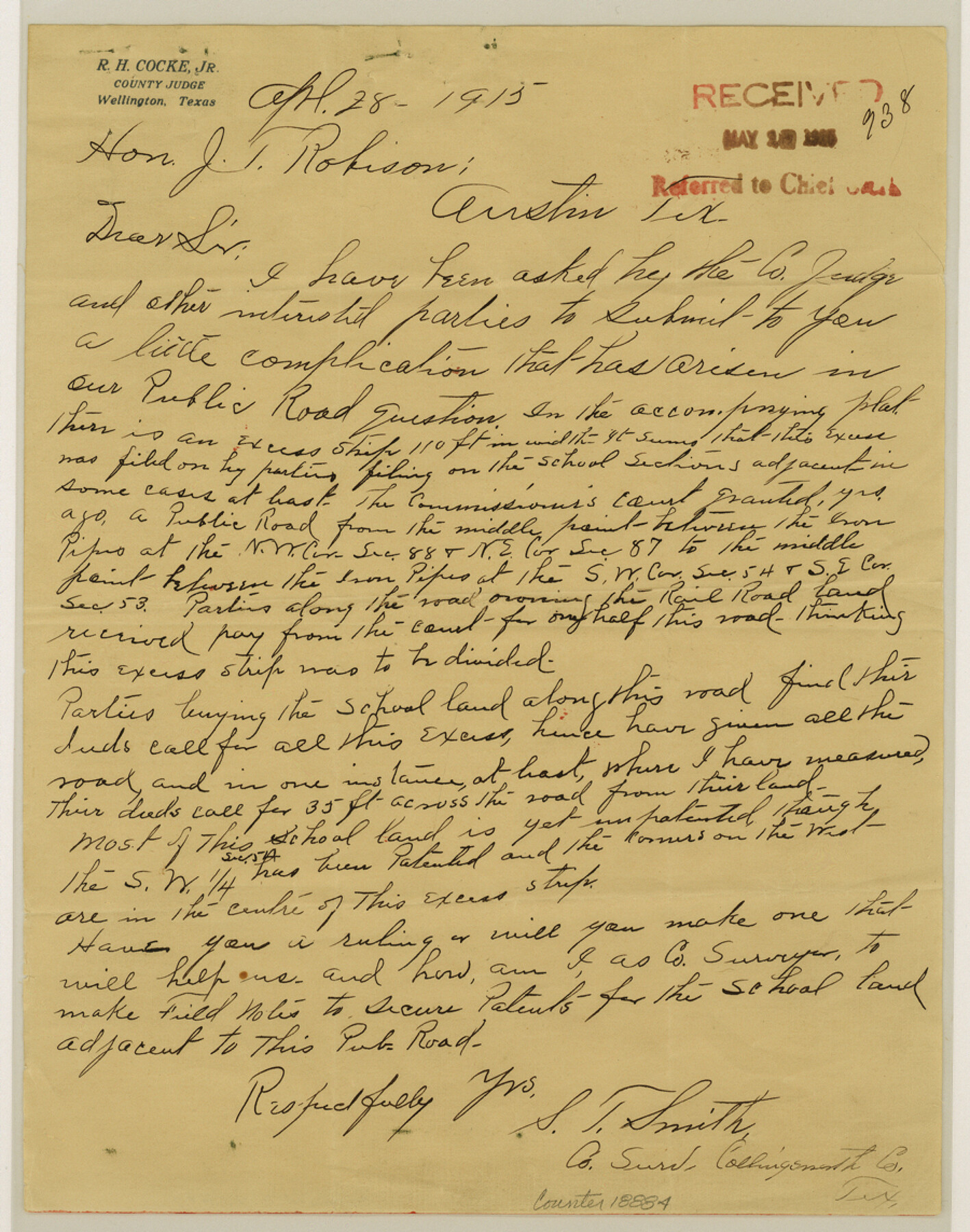
Collingsworth County Sketch File 7
[Sketches, correspondence, and explanation regarding Block 14]
-
Map/Doc
18884
-
Collection
General Map Collection
-
Object Dates
1915/4/28 (Creation Date)
1915/5/15 (File Date)
1915/5/5 (Creation Date)
-
People and Organizations
S.T. Smith (Surveyor/Engineer)
-
Counties
Collingsworth
-
Subjects
Surveying Sketch File
-
Height x Width
11.4 x 9.0 inches
29.0 x 22.9 cm
-
Medium
multi-page, multi-format
Part of: General Map Collection
Current Miscellaneous File 3

Print $34.00
- Digital $50.00
Current Miscellaneous File 3
1947
Size 9.0 x 6.2 inches
Map/Doc 73706
Kent County Sketch File 15

Print $8.00
- Digital $50.00
Kent County Sketch File 15
1936
Size 11.4 x 7.2 inches
Map/Doc 28842
Wood County Working Sketch 5

Print $20.00
- Digital $50.00
Wood County Working Sketch 5
1941
Size 27.8 x 38.7 inches
Map/Doc 62005
Map of Blanco County

Print $20.00
- Digital $50.00
Map of Blanco County
1878
Size 19.0 x 28.0 inches
Map/Doc 3305
Carte de la Louisiane et Pays Voisins pour servir a l'Histoire Generale des Voyages

Print $20.00
- Digital $50.00
Carte de la Louisiane et Pays Voisins pour servir a l'Histoire Generale des Voyages
1757
Size 10.1 x 15.5 inches
Map/Doc 97278
Val Verde County Sketch File H

Print $14.00
- Digital $50.00
Val Verde County Sketch File H
1891
Size 8.9 x 6.9 inches
Map/Doc 39291
Travis County Sketch File 65

Print $4.00
- Digital $50.00
Travis County Sketch File 65
1948
Size 9.1 x 9.1 inches
Map/Doc 38438
Parker County Working Sketch 15

Print $20.00
- Digital $50.00
Parker County Working Sketch 15
1982
Map/Doc 71465
[Right of Way & Track Map, The Texas & Pacific Ry. Co. Main Line]
![64675, [Right of Way & Track Map, The Texas & Pacific Ry. Co. Main Line], General Map Collection](https://historictexasmaps.com/wmedia_w700/maps/64675.tif.jpg)
Print $20.00
- Digital $50.00
[Right of Way & Track Map, The Texas & Pacific Ry. Co. Main Line]
Size 11.0 x 18.4 inches
Map/Doc 64675
Culberson County Sketch File 1b

Print $20.00
- Digital $50.00
Culberson County Sketch File 1b
Size 9.0 x 18.0 inches
Map/Doc 11260
Current Miscellaneous File 105

Print $18.00
- Digital $50.00
Current Miscellaneous File 105
Size 8.8 x 14.2 inches
Map/Doc 74680
Crane County Rolled Sketch 20

Print $20.00
- Digital $50.00
Crane County Rolled Sketch 20
Size 44.5 x 34.6 inches
Map/Doc 8684
You may also like
La Salle County Boundary File 57

Print $26.00
- Digital $50.00
La Salle County Boundary File 57
Size 9.2 x 4.7 inches
Map/Doc 56242
[Map showing T&P Lands in El Paso County]
![88931, [Map showing T&P Lands in El Paso County], Library of Congress](https://historictexasmaps.com/wmedia_w700/maps/88931.tif.jpg)
Print $20.00
[Map showing T&P Lands in El Paso County]
Size 22.4 x 17.3 inches
Map/Doc 88931
Red River County Sketch File A

Print $40.00
- Digital $50.00
Red River County Sketch File A
1900
Size 20.1 x 23.8 inches
Map/Doc 12236
Bird's Eye View of Corpus Christi

Print $20.00
Bird's Eye View of Corpus Christi
1887
Size 21.4 x 28.0 inches
Map/Doc 94113
The Chief Justice County of Liberty. Lands in Conflict with Harrisburg County

Print $20.00
The Chief Justice County of Liberty. Lands in Conflict with Harrisburg County
2020
Size 20.5 x 21.7 inches
Map/Doc 96056
General Highway Map. Detail of Cities and Towns in Nacogdoches County, Texas

Print $20.00
General Highway Map. Detail of Cities and Towns in Nacogdoches County, Texas
1961
Size 19.3 x 25.0 inches
Map/Doc 79608
Aransas Pass to Baffin Bay

Print $20.00
- Digital $50.00
Aransas Pass to Baffin Bay
1961
Size 42.1 x 35.4 inches
Map/Doc 73414
Cooke County Sketch File 15

Print $4.00
- Digital $50.00
Cooke County Sketch File 15
1860
Size 12.5 x 8.1 inches
Map/Doc 19250
Flight Mission No. DCL-6C, Frame 98, Kenedy County

Print $20.00
- Digital $50.00
Flight Mission No. DCL-6C, Frame 98, Kenedy County
1943
Size 18.6 x 22.3 inches
Map/Doc 85928
Louisiana and Texas Intracoastal Waterway, Section 7, Galveston Bay to Brazos River and Section 8, Brazos River to Matagorda Bay

Print $20.00
- Digital $50.00
Louisiana and Texas Intracoastal Waterway, Section 7, Galveston Bay to Brazos River and Section 8, Brazos River to Matagorda Bay
1937
Size 30.7 x 42.7 inches
Map/Doc 73064
Val Verde County Working Sketch 79

Print $40.00
- Digital $50.00
Val Verde County Working Sketch 79
1973
Size 51.0 x 32.4 inches
Map/Doc 72214
Parker County Working Sketch 29

Print $20.00
- Digital $50.00
Parker County Working Sketch 29
2020
Size 24.3 x 35.9 inches
Map/Doc 95961