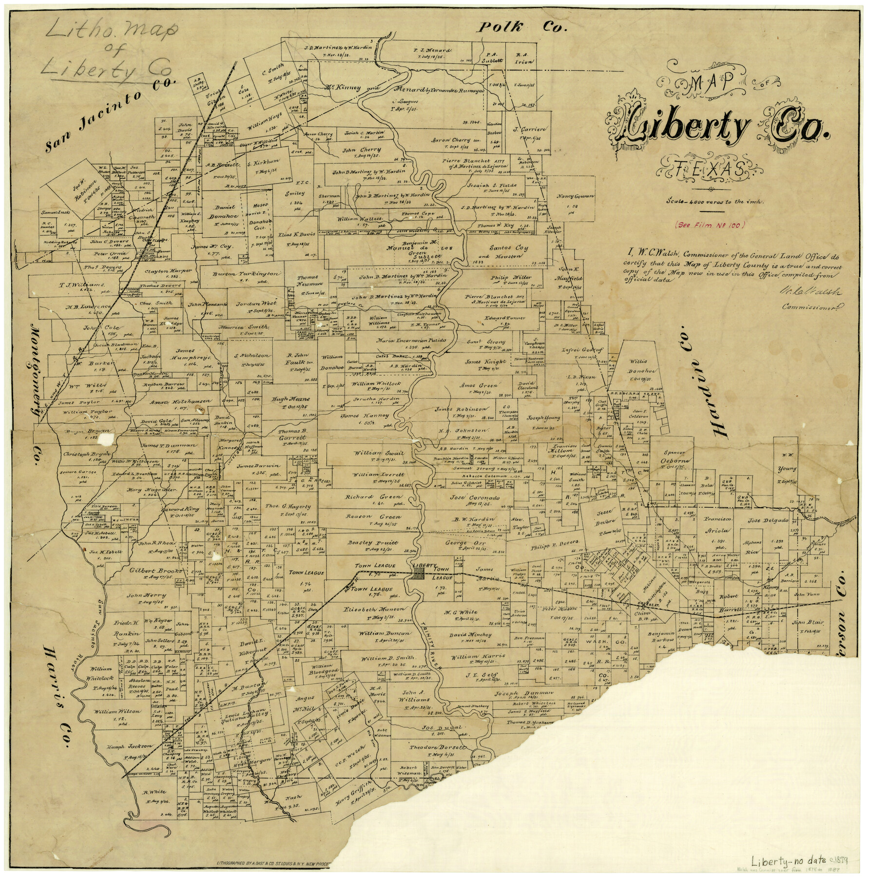
Map of Liberty County Texas
-
Map/Doc
3814
-
Collection
General Map Collection
-
Object Dates
1879 (Creation Date)
-
People and Organizations
W.C. Walsh (GLO Commissioner)
August Gast & Co. (Lithographer)
-
Counties
Liberty
-
Subjects
County
-
Height x Width
24.2 x 23.9 inches
61.5 x 60.7 cm
-
Features
Cleveland
Taylors Creek
Tarkington Bayou
HE&WT
Luces Bayou
Pine Island Bayou
San Jacinto River
Dayton Station
Liberty
Devers Station
Willow Marsh Bayou
Trinity River
T&NO
Hickory Island
Old River
Part of: General Map Collection
Flight Mission No. BRA-8M, Frame 68, Jefferson County

Print $20.00
- Digital $50.00
Flight Mission No. BRA-8M, Frame 68, Jefferson County
1953
Size 18.6 x 22.4 inches
Map/Doc 85588

Midland County Working Sketch 4

Print $20.00
- Digital $50.00
Midland County Working Sketch 4
Size 20.3 x 44.3 inches
Map/Doc 70984
Archer County Sketch File 6

Print $4.00
- Digital $50.00
Archer County Sketch File 6
Size 7.2 x 8.4 inches
Map/Doc 13634
Fayette County

Print $40.00
- Digital $50.00
Fayette County
1978
Size 42.8 x 54.5 inches
Map/Doc 77278
Bexar County Sketch File 8

Print $4.00
- Digital $50.00
Bexar County Sketch File 8
Size 9.4 x 7.7 inches
Map/Doc 14477
Williamson County Boundary File 3

Print $20.00
- Digital $50.00
Williamson County Boundary File 3
Size 18.5 x 23.6 inches
Map/Doc 60012
Chambers County NRC Article 33.136 Sketch 10

Print $44.00
- Digital $50.00
Chambers County NRC Article 33.136 Sketch 10
2014
Size 24.0 x 36.0 inches
Map/Doc 94498
Township 15 South Range 15 West and Fractional Township 16 South Range 15 West, South Western District, Louisiana

Print $20.00
- Digital $50.00
Township 15 South Range 15 West and Fractional Township 16 South Range 15 West, South Western District, Louisiana
1875
Size 19.6 x 24.7 inches
Map/Doc 65861
Freestone County Working Sketch 23

Print $20.00
- Digital $50.00
Freestone County Working Sketch 23
1982
Size 20.1 x 17.0 inches
Map/Doc 69265
Guadalupe County Sketch File 12

Print $8.00
- Digital $50.00
Guadalupe County Sketch File 12
1869
Size 12.9 x 8.2 inches
Map/Doc 24683
Flight Mission No. DAG-17K, Frame 119, Matagorda County

Print $20.00
- Digital $50.00
Flight Mission No. DAG-17K, Frame 119, Matagorda County
1952
Size 16.4 x 16.5 inches
Map/Doc 86339
You may also like
Rains County Working Sketch 10

Print $20.00
- Digital $50.00
Rains County Working Sketch 10
1998
Size 36.1 x 34.7 inches
Map/Doc 71836
Adrian Heights Adition (sic) to Adrian Located in Section 16, Block K11

Print $2.00
- Digital $50.00
Adrian Heights Adition (sic) to Adrian Located in Section 16, Block K11
Size 15.6 x 7.7 inches
Map/Doc 92096
[Sketch Showing Loma Blanca and San Antonio de Encinal Leagues, Brooks County, Texas]
![4448, [Sketch Showing Loma Blanca and San Antonio de Encinal Leagues, Brooks County, Texas], Maddox Collection](https://historictexasmaps.com/wmedia_w700/maps/4448-1.tif.jpg)
Print $3.00
- Digital $50.00
[Sketch Showing Loma Blanca and San Antonio de Encinal Leagues, Brooks County, Texas]
1912
Size 15.1 x 11.4 inches
Map/Doc 4448
Burnet County Working Sketch 9

Print $20.00
- Digital $50.00
Burnet County Working Sketch 9
1975
Size 39.7 x 25.2 inches
Map/Doc 67852
Ector County Working Sketch 16

Print $40.00
- Digital $50.00
Ector County Working Sketch 16
1956
Size 31.6 x 73.6 inches
Map/Doc 68859
Flight Mission No. CUG-3P, Frame 33, Kleberg County

Print $20.00
- Digital $50.00
Flight Mission No. CUG-3P, Frame 33, Kleberg County
1956
Size 18.4 x 22.2 inches
Map/Doc 86238
Flight Mission No. CUG-3P, Frame 142, Kleberg County

Print $20.00
- Digital $50.00
Flight Mission No. CUG-3P, Frame 142, Kleberg County
1956
Size 18.7 x 22.3 inches
Map/Doc 86277
Map of Harrison County

Print $20.00
- Digital $50.00
Map of Harrison County
1871
Size 18.0 x 19.1 inches
Map/Doc 1117
Jeff Davis County Working Sketch 11

Print $20.00
- Digital $50.00
Jeff Davis County Working Sketch 11
1947
Size 23.3 x 43.1 inches
Map/Doc 66506
Tyler County Working Sketch 25

Print $20.00
- Digital $50.00
Tyler County Working Sketch 25
1909
Size 29.8 x 26.7 inches
Map/Doc 69495
Crockett County Sketch File 86

Print $4.00
- Digital $50.00
Crockett County Sketch File 86
1939
Size 11.5 x 9.1 inches
Map/Doc 19908
Current Miscellaneous File 22

Print $12.00
- Digital $50.00
Current Miscellaneous File 22
1952
Size 14.2 x 8.8 inches
Map/Doc 73876